Le Sueur River facts for kids
Quick facts for kids Le Sueur River |
|
|---|---|

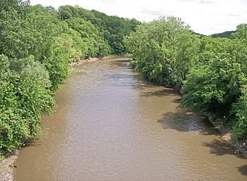
The Le Sueur River near its mouth in South Bend Township in 2007
|
|

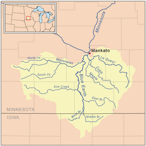
Map of the Blue Earth watershed that shows the Le Sueur River
|
|
| Country | United States |
| State | Minnesota |
| Physical characteristics | |
| Main source | Hartland Township, Freeborn County 1,279 ft (390 m) 43°46′03″N 93°28′13″W / 43.76750°N 93.47028°W |
| River mouth | Blue Earth River South Bend Township, Blue Earth County 774 ft (236 m) 44°07′36″N 94°02′52″W / 44.12667°N 94.04778°W |
| Length | 110.9 mi (178.5 km) |
| Basin features | |
| Basin size | 1,089 sq mi (2,820 km2) |
| Tributaries |
|

The Le Sueur River (pronounced lay-SEWER) is a river in southern Minnesota, United States. It is about 111 miles (178 km) long. The Le Sueur River is a tributary of the Blue Earth River. This means it is a smaller river that flows into a larger one.
The river is part of a huge watershed that eventually reaches the Mississippi River. A watershed is an area of land where all the water drains into a single river or lake. The Le Sueur River's watershed covers 1,089 square miles (2,280 km2). It is the biggest river that flows into the Blue Earth River.
The river was named after Pierre-Charles Le Sueur, a French explorer who explored North America a long time ago.
Contents
Where the Le Sueur River Flows
The Le Sueur River starts in Hartland Township. This area is in the northwestern part of Freeborn County. From there, it first flows north. It goes through the very southwestern tip of Steele County. Then it enters Waseca County.
After that, the river turns west. It winds its way through Blue Earth County. It even passes by the town of St. Clair. Finally, it flows into the Blue Earth River. This meeting point is southwest of Mankato. It's about three miles (5 km) before the Blue Earth River joins the Minnesota River.
Rivers Joining the Le Sueur
The Le Sueur River has two main rivers that flow into it. These are called its largest tributaries. They are the Cobb River and the Maple River. Both of these rivers join the Le Sueur from the south. The Maple River joins about six miles (10 km) upstream from the Le Sueur's mouth. The Cobb River joins about eight miles (13 km) upstream.
There is also a smaller river called the Little Le Sueur River. It flows into the Le Sueur River in Waseca and Steele Counties.
The River's Surroundings
For most of its journey, the Le Sueur River flows over flat lands. These lands were shaped by ancient glaciers. In its lower parts, the river has carved deep ravines into the ground.
Long ago, parts of a large forest called the Big Woods followed the river's path. This forest had many hardwood trees. Today, most of that forest land has been turned into farms.
Farming Near the River
The area around the Le Sueur River is mostly used for farming. About 84% of the larger Blue Earth River watershed is farmland. Farmers mainly grow corn and soybeans here.
How Fast the River Flows
The United States Geological Survey measures how much water flows in the river. They have a special station near a community called Rapidan. This station is about two miles (3 km) upstream from where the river meets the Blue Earth River.
Between 1940 and 2005, the river's average flow was 549 cubic feet per second. That's like 16 cubic meters per second.
River Flow Records
- The highest flow ever recorded was on April 8, 1965. On that day, the river flowed at 24,700 cubic feet per second (699 cubic meters per second). That's a lot of water!
- The lowest flow ever recorded was on February 9, 1959. The river was flowing at only 1.6 cubic feet per second (0 cubic meters per second). This shows how much the river's flow can change.
 | May Edward Chinn |
 | Rebecca Cole |
 | Alexa Canady |
 | Dorothy Lavinia Brown |

