Waseca County, Minnesota facts for kids
Quick facts for kids
Waseca County
|
|
|---|---|

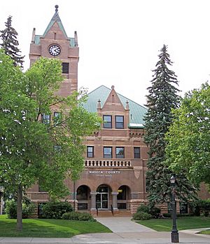
Waseca County Courthouse in 2007
|
|

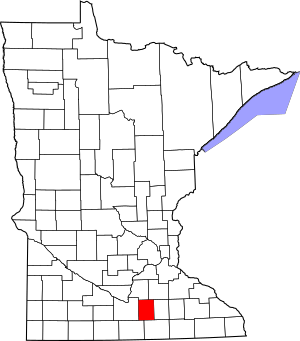
Location within the U.S. state of Minnesota
|
|
 Minnesota's location within the U.S. |
|
| Country | |
| State | |
| Founded | February 27, 1857 |
| Named for | Waseca (settlement) |
| Seat | Waseca |
| Largest city | Waseca |
| Area | |
| • Total | 433 sq mi (1,120 km2) |
| • Land | 423 sq mi (1,100 km2) |
| • Water | 9.6 sq mi (25 km2) 2.2%% |
| Population
(2020)
|
|
| • Total | 18,968 |
| • Estimate
(2024)
|
18,684 |
| • Density | 43.81/sq mi (16.914/km2) |
| Time zone | UTC−6 (Central) |
| • Summer (DST) | UTC−5 (CDT) |
| Congressional district | 1st |
Waseca County is a county located in the state of Minnesota in the United States. In 2020, about 18,968 people lived there. The main town and government center of the county is Waseca.
Contents
The Story of Waseca County
Waseca County was officially created on February 27, 1857. It was formed from a part of Steele County by the Minnesota Territory government. The first county seat, or main town for government, was Wilton.
The name "Waseca" comes from the Dakota language. It means "rich," which describes the fertile soil in the area. This name was first used for a farming settlement started in 1855. Later, the city of Waseca grew near this settlement.
In the late 1860s, a railroad line was built through the town of Waseca. This helped the town grow quickly. By 1870, people voted to move the county seat to the city of Waseca. The borders of Waseca County have stayed the same since it was first created.
Exploring Waseca County's Land
Waseca County has many rivers and streams. The Le Sueur River flows west through the county. It joins the Blue Earth River in a nearby county. The Little Le Sueur River also helps drain water from the southeast. Other streams like Bull Run Creek and the Little Cobb River flow through the county.
The land in Waseca County has gentle, rolling hills. Many lakes dot the landscape. Most of the land is used for farming. The highest point in the county is about 1,240 feet (378 meters) above sea level.
Waseca County covers about 433 square miles (1,121 square kilometers). Most of this is land, with about 9.6 square miles (25 square kilometers) being water. This county is special because it has no large forests. Instead, it has rich prairie and savanna soils, which are great for farming.
Getting Around Waseca County
The county has a public transportation service called Southern Minnesota Area Rural Transit. Many important roads also cross through Waseca County. These roads help people travel and transport goods.
Main Roads in Waseca County
Neighboring Counties
Waseca County shares its borders with several other counties:
- Rice County to the northeast
- Steele County to the east
- Freeborn County to the southeast
- Faribault County to the southwest
- Blue Earth County to the west
- Le Sueur County to the northwest
Special Natural Areas
Waseca County has several protected areas. These are called State Wildlife Management Areas. They help protect local wildlife and their homes.
- Findley State Wildlife Management Area
- Kanne State Wildlife Management Area
- Moonan State Wildlife Management Area
- Mueller State Wildlife Management Area
- Senn-Rich State Wildlife Management Area
- Teal State Wildlife Management Area
- Waseca State Wildlife Management Area
Lakes of Waseca County
Many beautiful lakes can be found in Waseca County:
- Buffalo Lake
- Clear Lake
- Everson Lake
- Goose Lake
- Hayes Lake
- Knutsen Lake
- Lake Elysian (partly in the county)
- Lilly Lake
- Lily Lake (partly in the county)
- Loon Lake
- Mott Lake
- Reeds Lake
- Reese Lake
- Rice Lake (near Janesville Township)
- Rice Lake (near Woodville Township)
- Saint Olaf Lake
- Sibert Lake
- Silver Lake
- Toners Lake
- Trenton Lake (partly in the county)
- Watkins Lake
People of Waseca County
| Historical population | |||
|---|---|---|---|
| Census | Pop. | %± | |
| 1860 | 2,601 | — | |
| 1870 | 7,854 | 202.0% | |
| 1880 | 12,385 | 57.7% | |
| 1890 | 13,313 | 7.5% | |
| 1900 | 14,760 | 10.9% | |
| 1910 | 13,466 | −8.8% | |
| 1920 | 14,133 | 5.0% | |
| 1930 | 14,412 | 2.0% | |
| 1940 | 15,186 | 5.4% | |
| 1950 | 14,957 | −1.5% | |
| 1960 | 16,041 | 7.2% | |
| 1970 | 16,663 | 3.9% | |
| 1980 | 18,448 | 10.7% | |
| 1990 | 18,079 | −2.0% | |
| 2000 | 19,526 | 8.0% | |
| 2010 | 19,136 | −2.0% | |
| 2020 | 18,968 | −0.9% | |
| 2024 (est.) | 18,684 | −2.4% | |
| U.S. Decennial Census 1790-1960 1900-1990 1990-2000 2010-2020 |
|||
Population in 2020
According to the 2020 census, Waseca County had a population of 18,968 people.
| Group | Number | Percentage |
|---|---|---|
| White | 16,538 | 87.2% |
| Black or African American | 336 | 1.8% |
| Native American | 114 | 0.6% |
| Asian | 111 | 0.6% |
| Pacific Islander | 12 | 0.06% |
| Other/Mixed | 586 | 3.1% |
| Hispanic or Latino | 1,271 | 6.7% |
Towns and Communities
Cities
- Elysian (partly in the county)
- Janesville
- New Richland
- Waldorf
- Waseca (This is the county seat.)
Smaller Communities
- Alma City
- Lake Elysian
- Matawan
- Otisco
- Palmer
- Saint Mary
- Smiths Mill
- Vista
- Wilton
Townships
- Alton Township
- Blooming Grove Township
- Byron Township
- Freedom Township
- Iosco Township
- Janesville Township
- New Richland Township
- Otisco Township
- St. Mary Township
- Vivian Township
- Wilton Township
- Woodville Township
How Waseca County Votes
Waseca County usually votes for the Republican Party in presidential elections. Since 1936, the county has chosen a Democratic candidate only a few times.
State Government Representatives (2021–2023)
| Position | Name | Party | District | |
|---|---|---|---|---|
| Senate | Julie Rosen | Republican | District 23 | |
| Senate | John Jasinski | Republican | District 24 | |
| House of Representatives | Jeremy Munson | Republican | District 23B | |
| House of Representatives | John Petersburg | Republican | District 24A | |
National Government Representatives (2021–2023)
| Position | Name | Party | District | |
|---|---|---|---|---|
| House of Representatives | Brad Finstad | Republican | 1st | |
| Senate | Amy Klobuchar | Democrat | N/A | |
| Senate | Tina Smith | Democrat | N/A | |
See also
 In Spanish: Condado de Waseca para niños
 | Misty Copeland |
 | Raven Wilkinson |
 | Debra Austin |
 | Aesha Ash |


