
List of rivers of Minnesota facts for kids
Minnesota is a state famous for its many lakes, but it also has thousands of rivers and streams! These waterways are super important. They flow for about 69,000 miles (111,000 km) all across the state.
The mighty Mississippi River starts its long journey right here in Minnesota. It begins at Lake Itasca and travels about 680 miles (1,090 km) through Minnesota before reaching the Iowa border. Along the way, other big rivers join it, like the Minnesota River near Fort Snelling and the St. Croix River near Hastings.
Another major river, the Red River, flows north from Minnesota into Canada. It drains the northwest part of the state, which was once covered by a giant ancient lake called Lake Agassiz.

Contents
Understanding Watersheds
A watershed is like a giant bowl. It's an area of land where all the rain and snowmelt drain into a common river, lake, or ocean. Think of it as a big funnel for water!
Minnesota's rivers are grouped by which larger body of water they eventually flow into. These groups are called drainage basins or watersheds. Some rivers flow into the Great Lakes, some into the Mississippi River, and others into Hudson Bay in Canada.
Major River Basins in Minnesota
Minnesota has three main river basins. Each one sends its water in a different direction!
Great Lakes Basin
Water in this basin eventually flows into Lake Superior, one of the Great Lakes. From there, it travels through other Great Lakes and eventually reaches the Atlantic Ocean.
Lake Superior Rivers

Many rivers in northeastern Minnesota flow directly into Lake Superior. These include:
- Pigeon River (Minnesota, Ontario) – This river is about 31.2 miles (50.2 km) long.
- Brule River – It flows for about 40.4 miles (65.0 km).
- Cascade River – This river is about 17.1 miles (27.5 km) long.
- Poplar River – It stretches for about 21.7 miles (34.9 km).
- Temperance River – This river is about 39.2 miles (63.1 km) long.
- Manitou River – It flows for about 24.9 miles (40.1 km).
- Baptism River – This river is about 8.8 miles (14.2 km) long.
- Beaver River – It flows for about 23.4 miles (37.7 km).
- Gooseberry River – This river is about 23 miles (37 km) long.
- Knife River – It flows for about 23.9 miles (38.5 km).
- French River – This river is about 13 miles (21 km) long.
- Lester River – It flows for about 19.3 miles (31.1 km).
- St. Louis River (Minnesota, Wisconsin) – This is a very important river, about 192 miles (309 km) long.
- Cloquet River – A major tributary of the St. Louis River, about 104 miles (167 km) long.
- Nemadji River – This river is about 70.8 miles (114.0 km) long.
Mississippi River Basin
The largest river basin in Minnesota is the one that feeds into the Mississippi River. This mighty river flows all the way to the Gulf of Mexico.
Upper Mississippi River (Below St. Anthony Falls)
This part of the Mississippi River basin includes rivers that join the Mississippi after it passes Saint Anthony Falls.
- Mississippi River – The longest river in the United States, about 2,320 miles (3,730 km) long in total. About 680 miles (1,090 km) of it are in Minnesota.
- Des Moines River (Iowa, Minnesota, Missouri) – About 525 miles (845 km) long.
- Cedar River (Minnesota, Iowa) – About 338 miles (544 km) long.
- Root River – This river is about 80 miles (130 km) long.
- Whitewater River – About 16.6 miles (26.7 km) long.
- Zumbro River – This river is about 64.6 miles (104.0 km) long.
- Cannon River – About 112 miles (180 km) long.
- Vermillion River – This river is about 59.6 miles (95.9 km) long.
St. Croix River Basin
The St. Croix River is a beautiful river that forms part of the border between Minnesota and Wisconsin. It's about 169 miles (272 km) long and eventually flows into the Mississippi River.

Some rivers that flow into the St. Croix River include:
- Sunrise River – About 39.1 miles (62.9 km) long.
- Snake River – About 104 miles (167 km) long.
- Kettle River – About 83.6 miles (134.5 km) long.
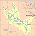
Minnesota River Basin
The Minnesota River is the longest river that flows entirely within Minnesota. It's about 370 miles (600 km) long and joins the Mississippi River near the Twin Cities.

Important rivers that flow into the Minnesota River include:
- Blue Earth River – About 108 miles (174 km) long.
- Le Sueur River – About 110.9 miles (178.5 km) long.
- Watonwan River – About 113.2 miles (182.2 km) long.
- Cottonwood River – About 152.4 miles (245.3 km) long.
- Redwood River – About 127.1 miles (204.6 km) long.
- Yellow Medicine River – About 107.2 miles (172.5 km) long.
- Chippewa River – About 153 miles (246 km) long.
- Lac qui Parle River – About 118.3 miles (190.4 km) long.
- Pomme de Terre River – About 124.5 miles (200.4 km) long.
- Little Minnesota River – About 71.4 miles (114.9 km) long.
Upper Mississippi River (Headwaters Region)
This section covers rivers that flow into the Mississippi River before it reaches St. Anthony Falls, including the area where the river begins.
- Rum River – About 151 miles (243 km) long.
- Crow River – About 24.8 miles (39.9 km) long.
- North Fork Crow River – About 157.5 miles (253.5 km) long.
- South Fork Crow River – About 116 miles (187 km) long.
- Elk River – About 84.0 miles (135.2 km) long.
- Sauk River – About 122 miles (196 km) long.
- Crow Wing River – About 113 miles (182 km) long.
- Long Prairie River – About 96 miles (154 km) long.
- Redeye River – About 73 miles (117 km) long.
- Pine River – About 56.9 miles (91.6 km) long.
- Willow River – About 45 miles (72 km) long.
- Leech Lake River – This river flows out of Leech Lake.
- Schoolcraft River – About 30 miles (48 km) long.
- Little Mississippi River – This is a small river near the very start of the Mississippi.
Hudson Bay Basin
Water in this basin flows north into Canada and eventually reaches the Hudson Bay.
Red River of the North Basin
The Red River of the North is the second-longest river flowing through Minnesota. It forms the border with North Dakota and flows north into Manitoba, Canada. It's about 550 miles (890 km) long, with about 457.1 miles (735.6 km) in Minnesota.

Rivers that flow into the Red River of the North include:
- Roseau River (Manitoba, Minnesota) – About 214 miles (344 km) long.
- Tamarac River – About 82.1 miles (132.1 km) long.
- Snake River – About 91.0 miles (146.5 km) long.
- Red Lake River – About 193 miles (311 km) long.
- Clearwater River – About 147 miles (237 km) long.
- Thief River – About 40.3 miles (64.9 km) long.
- Red Lake – This large lake feeds the Red Lake River.
- Sand Hill River – About 101 miles (163 km) long.
- Wild Rice River – About 183 miles (295 km) long.
- Buffalo River – About 139 miles (224 km) long.
- Otter Tail River – About 192 miles (309 km) long.
- Bois de Sioux River – About 41 miles (66 km) long.
- Mustinka River – About 68 miles (109 km) long.
Lake of the Woods Basin
Water in this basin flows into Lake of the Woods, a large lake on the border with Canada. From there, it eventually reaches Hudson Bay.
- Rainy River – This river forms part of the border with Ontario, Canada. It's about 137 miles (220 km) long.
- Big Fork River – About 168 miles (270 km) long.
- Little Fork River – About 160 miles (260 km) long.
- Rainy Lake/Kabetogama Lake/Namakan Lake/Crane Lake – These lakes are part of a connected system that feeds the Rainy River.
- Vermilion River – This river flows into Vermilion Lake, which is connected to this system.
- Vermilion Lake – A large lake in northern Minnesota.
- Kawishiwi River – This river flows through many lakes and connects to the system.
- South Kawishiwi River – A major branch of the Kawishiwi River.
- Isabella River – Another important tributary.
- Vermilion River – This river flows into Vermilion Lake, which is connected to this system.
- Knife River – This river flows into Knife Lake.
- Saganaga Lake – A large lake on the border with Canada.
Alphabetical List of Rivers
Minnesota has so many rivers and streams, it would be a very long list to name them all! The state has 6,564 natural rivers and streams. Some of these are even special "trout streams," which means they are great for fishing.
Images for kids
-
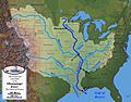
Mississippi River drainage basin
-
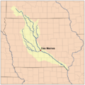
Des Moines River watershed
-
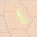
Iowa River watershed
-
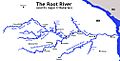
Root River tributaries
-
Minnesota River drainage basin
-
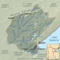
Map of the Saint Louis River drainage basin showing the Cloquet River
-
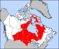
Hudson Bay drainage basin


See also
- List of lakes of Minnesota
- List of longest streams of Minnesota
