
Cannon River (Minnesota) facts for kids
Quick facts for kids Cannon River |
|
|---|---|

The Cannon River as seen from a snowshoe trail in Miesville Ravine Park Reserve on a winter day.
|
|
| Country | United States |
| State | Minnesota |
| Cities | Red Wing, Welch, Cannon Falls, Randolph, Northfield, Dundas, Faribault, Warsaw, Morristown, Waterville |
| Physical characteristics | |
| Main source | Lake Tetonka Le Sueur County, near Waterville, Minnesota, United States 44°13′42″N 93°35′50″W / 44.228326°N 93.597203°W |
| River mouth | Mississippi River Goodhue County, near Red Wing, Minnesota, United States 44°36′09″N 92°35′23″W / 44.602583°N 92.589771°W |
| Length | 112 mi (180 km) |
| Basin features | |
| Basin size | 1,460 sq mi (3,800 km2) |
| Tributaries |
|
The Cannon River is a river in the U.S. state of Minnesota. It flows for about 112 miles (180 km). The river starts at Lake Tetonka near Waterville. It then flows to Red Wing, where it joins the mighty Mississippi River.
The Cannon River drains an area of about 1460 square miles (3,780 km²). It passes through several counties. These include Le Sueur, Rice, Dakota, and Goodhue counties.
While mostly calm, some parts of the Cannon River can be tricky for canoes. You might need to carry your canoe around several dams. Be careful of low bridges and fallen trees, especially when the water is high. The river's width changes from about 50 to 200 feet (15 to 60 meters).
Contents
River Flow and Features

The river's water level is usually highest in early April. Very heavy rains can sometimes cause the river to flood. There is a dam at Lake Byllesby. This dam helps control the river's flow. However, it does not affect water levels much for canoeing downstream.
From Faribault, Minnesota to its end, the Cannon River drops about 280 feet (85 meters). This is an average of 4.8 feet per mile (1 meter per km). The Cannon River is so special that it is a designated Minnesota Wild and Scenic River. In its upper part, the river flows through many lakes in western Rice County. The main river that flows into the Cannon River is the Straight River. It joins the Cannon in Faribault.
Exploring the River's Landscape
The Cannon River is surrounded by beautiful scenery. You'll see rolling hills, tall bluffs, farmlands, and thick woods. In 1910, a dam was built by H.M. Byllesby. This dam created Lake Byllesby Reservoir for hydroelectric power. This means it used the river's water to make electricity.
Below Cannon Falls, the river enters a wide gorge. Here, the bluffs can be as high as 300 feet (100 meters). The Cannon River flows over different types of rock. As the river cut through these rocks over time, it created cool rock formations. You can see layers of St. Peter Sandstone and other rocks.
The area past Cannon Falls is called the Driftless Area. This region was not covered by ice during the last ice age. Because of this, the river was able to carve a very impressive canyon. The upper part of the river, however, was affected by glaciers.
Animals and Plants of the Cannon River
The Cannon River is home to many different animals and plants. In the lakes and slower parts of the river, you can find fish like northern pike, black crappies, bluegills, and bullheads. Downstream from Faribault, you might catch smallmouth bass, northern pike, walleye, and channel catfish.

Many types of wildlife live in the river valley. These include white-tailed deer, beavers, otters, raccoons, bobcats, red fox, gray fox, and coyotes. If you're lucky, you might even spot bald eagles near the Mississippi River.
A very special plant called the Dwarf Trout Lily grows only in the Cannon River watershed. It is a rare and unique flower.
Cannon River's Rich History
People have lived along the Cannon River for at least 12,000 years. The Dakota people called it Inyan Bosndata, which means "Standing Rock River." Around 1000 CE, the Mississippian Culture lived here. They were farmers and also hunted buffalo to the west. The Cannon River was an important path from the Mississippi River to the plains where buffalo were common.
The "Standing Rock" in the Dakota name refers to Castle Rock. This is a rock formation located near the community of Castle Rock.
The mouth of the Cannon River was a very important place for these early cultures. Later, French fur traders called the river "La Riviere aux Canots," meaning "the river of canoes." This was because Native Americans and traders often hid their canoes near the river's mouth.
In the late 1800s, the river was important for industry. In 1877, there were 15 flour mills along the river between Faribault and Northfield alone. You can still see the old limestone walls of the Archibald Mill in Dundas. The Cannon River also flows through the Science Center at the Maltby Nature Preserve in Randolph.
Historic Industries Along the River
The clever millers in the Cannon Valley used the river's power to run their flour mills. In the mid-to-late 1800s, many new ideas for flour milling were developed here. These inventions changed how milling was done around the world. The first mills in towns like Faribault, Morristown, Dundas, Northfield, Cannon Falls, and Red Wing helped create the first economy in the Cannon Valley. Important people like John North and Captain Jesse Ames helped develop new technology.
Some of these early mill companies still exist today. For example, Malt-O-Meal is a well-known food company. The Faribault Woolen Mill also continues the tradition of textile milling.
Parks and Recreation Along the Cannon River
The Cannon Valley Trail is a great place to explore the river. It runs along the south bank of the river between Cannon Falls and Red Wing. This trail offers beautiful views of the farmlands and the river valley.
Sakatah Lake State Park is located on a wider part of the river near Waterville. Another trail, the 40-mile Sakatah-Singing Hills Trail, starts in Faribault. It winds west along the Cannon River, passing several lakes. This asphalt trail used to be the Cannon Valley Railroad, built in the 1880s. It's now a popular spot for walking, biking, and other activities all year round.
Images for kids
-
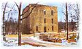
Oxford Mill, Cannon Falls.

