Castle Rock, Minnesota facts for kids
Quick facts for kids
Castle Rock
|
|
|---|---|
| Country | United States |
| State | Minnesota |
| County | Dakota County |
| Township | Castle Rock Township |
| Elevation | 938 ft (286 m) |
| Time zone | UTC-6 (Central (CST)) |
| • Summer (DST) | UTC-5 (CDT) |
| ZIP code |
55010
|
| Area code(s) | 651, 507 |
| GNIS feature ID | 640969 |
Castle Rock is a small community in Minnesota, United States. It's not a city with its own government. Instead, it's part of Castle Rock Township in Dakota County.
Contents
Where is Castle Rock Located?
Castle Rock is about 7 miles (11 km) north of Northfield. Other nearby towns include Farmington and Randolph. You can find it close to State Highway 3 (MN 3).
Why is it Called Castle Rock?
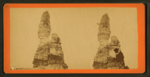
The community gets its name from a special rock formation. This rock is on private land where 275th Street and Cambodia Avenue meet. The Dakota Native Americans called this formation Inyan Bosdata, which means "Rock Standing on End." This rock also gave its name to a nearby river, which is now known as the Cannon River.
A Look at Castle Rock's Past
The first post office in Castle Rock opened in 1858. The community itself was named after the larger area, Castle Rock Township.
Learning in Castle Rock
Students in the area attend Prairie Creek Community School. This school helps educate the young people of Castle Rock.
 | Victor J. Glover |
 | Yvonne Cagle |
 | Jeanette Epps |
 | Bernard A. Harris Jr. |


