Randolph, Minnesota facts for kids
Quick facts for kids
Randolph
|
|
|---|---|

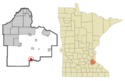
Location of the city of Randolph
within Dakota County, Minnesota |
|
| Country | United States |
| State | Minnesota |
| County | Dakota |
| Area | |
| • Total | 0.98 sq mi (2.54 km2) |
| • Land | 0.95 sq mi (2.47 km2) |
| • Water | 0.03 sq mi (0.07 km2) |
| Elevation | 879 ft (268 m) |
| Population
(2020)
|
|
| • Total | 466 |
| • Density | 488.98/sq mi (188.85/km2) |
| Time zone | UTC-6 (Central (CST)) |
| • Summer (DST) | UTC-5 (CDT) |
| ZIP code |
55065
|
| Area code(s) | 507, 651 |
| FIPS code | 27-53098 |
| GNIS feature ID | 0649818 |
Randolph is a small city located in Dakota County, Minnesota, in the United States. In 2020, about 466 people lived there.
Contents
History of Randolph
A post office has been open in Randolph since 1886. The city got its name from Randolph Township, which is the area around it.
Where is Randolph Located?
Randolph is in the southern part of Dakota County. It covers about 0.98 square miles (2.54 square kilometers). Most of this area is land, with a small part being water.
The city is inside Randolph Township. However, the city and the township are separate local governments.
Nearby Natural Features
Lake Byllesby and the Cannon River are both close to Randolph. The borders of Dakota, Goodhue, and Rice counties are also nearby.
People Living in Randolph
| Historical population | |||
|---|---|---|---|
| Census | Pop. | %± | |
| 1910 | 182 | — | |
| 1920 | 170 | −6.6% | |
| 1930 | 214 | 25.9% | |
| 1940 | 236 | 10.3% | |
| 1950 | 259 | 9.7% | |
| 1960 | 315 | 21.6% | |
| 1970 | 350 | 11.1% | |
| 1980 | 351 | 0.3% | |
| 1990 | 331 | −5.7% | |
| 2000 | 318 | −3.9% | |
| 2010 | 436 | 37.1% | |
| 2020 | 466 | 6.9% | |
| U.S. Decennial Census | |||
Randolph's Population in 2010
In 2010, 436 people lived in Randolph. There were 168 households and 118 families. The city had about 454 people per square mile.
Most residents, 98.4%, were White. A small number were Asian or from two or more races. About 1.8% of the population was Hispanic or Latino.
Many households (37.5%) had children under 18. Over half (53.6%) were married couples. The average household had 2.60 people. The average family had 3.03 people.
The average age in Randolph was 36 years old. About 27.5% of people were under 18. About 7.8% were 65 or older. The population was almost evenly split between males (51.1%) and females (48.9%).
Getting Around Randolph
Roads and Highways
Several important roads pass through Randolph. These include State Highway 56, County Road 88 (also known as 292nd Street East), and County Road 83.
Other main roads close by are U.S. Highway 52, State Highway 19, County Road 47 (Northfield Boulevard), and County Road 86.
Local Airport
Stanton Airfield is an airport located about five miles south of Randolph. It is mainly used for general aviation, which means it's for private planes and smaller flights, not large commercial airlines.
See also
 In Spanish: Randolph (Minnesota) para niños
 | Anna J. Cooper |
 | Mary McLeod Bethune |
 | Lillie Mae Bradford |

