Morristown, Minnesota facts for kids
Quick facts for kids
Morristown
|
|
|---|---|

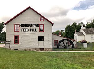
Morristown Feed Mill
|
|
| Nickname(s):
Heaven On Earth
|
|
| Motto(s):
Best Town By A Dam Site
|
|

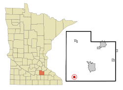
Location of Morristown, Minnesota
|
|
| Country | United States |
| State | Minnesota |
| County | Rice |
| Founded | 1855 |
| Incorporated | 1874 |
| Area | |
| • Total | 1.14 sq mi (2.96 km2) |
| • Land | 1.14 sq mi (2.95 km2) |
| • Water | 0.00 sq mi (0.00 km2) |
| Elevation | 1,004 ft (306 m) |
| Population
(2020)
|
|
| • Total | 949 |
| • Estimate
(2022)
|
1,008 |
| • Density | 832.46/sq mi (321.46/km2) |
| Time zone | UTC−6 (Central (CST)) |
| • Summer (DST) | UTC−5 (CDT) |
| ZIP code |
55052
|
| Area code(s) | 507 |
| FIPS code | 27-44296 |
| GNIS feature ID | 2395412 |
| Sales tax | 7.375% |
Morristown is a small city located in Rice County, Minnesota, United States. In 2020, about 949 people lived there.
Contents
A Look Back at Morristown's History
Morristown was officially planned out and mapped in 1855. It was named after Walter Morris, one of the first people to settle there. The city was officially formed in 1874.
Where is Morristown? (Geography)
Morristown is a small city, covering about 1.14 square miles (2.96 square kilometers). Most of this area is land, with a tiny bit of water.
Almost all of Morristown is located on the southern bank of the Cannon River. This river is an important natural feature nearby. Minnesota State Highway 60 is a main road that runs through the community, making it easy to get around.
Who Lives in Morristown? (Demographics)
| Historical population | |||
|---|---|---|---|
| Census | Pop. | %± | |
| 1870 | 317 | — | |
| 1880 | 517 | 63.1% | |
| 1890 | 517 | 0.0% | |
| 1900 | 589 | 13.9% | |
| 1910 | 592 | 0.5% | |
| 1920 | 688 | 16.2% | |
| 1930 | 613 | −10.9% | |
| 1940 | 677 | 10.4% | |
| 1950 | 533 | −21.3% | |
| 1960 | 616 | 15.6% | |
| 1970 | 659 | 7.0% | |
| 1980 | 639 | −3.0% | |
| 1990 | 784 | 22.7% | |
| 2000 | 981 | 25.1% | |
| 2010 | 987 | 0.6% | |
| 2020 | 949 | −3.9% | |
| 2022 (est.) | 1,008 | 2.1% | |
| U.S. Decennial Census 2020 Census |
|||
Population in 2010
In 2010, there were 987 people living in Morristown. These people lived in 388 homes, and 255 of these were families. The city had about 968 people per square mile.
Most of the people living in Morristown were White (96.3%). A small number were African American (0.6%), Asian (0.2%), or from other backgrounds. About 3.6% of the population identified as Hispanic or Latino.
In 33.2% of homes, there were children under 18 years old. Many homes (48.7%) had married couples living together. About 13.1% of homes had someone living alone who was 65 years old or older. The average home had 2.49 people.
The average age of people in the city was 37.8 years. About 25.9% of residents were under 18. About 15.4% were 65 years old or older. The population was almost evenly split between males (50.3%) and females (49.7%).
Learning in Morristown (Education)
Public schools in Morristown are part of the Waterville-Elysian-Morristown School District. This district helps make sure students get a good education.
Famous People from Morristown
Some notable people have connections to Morristown:
- Henry Waldo Coe: A doctor and politician who lived on the frontier.
- Seth H. Kenney: A farmer and politician.
See Also
In Spanish: Morristown (Minnesota) para niños
 | Lonnie Johnson |
 | Granville Woods |
 | Lewis Howard Latimer |
 | James West |

