
Root River (Minnesota) facts for kids
Quick facts for kids Root River |
|
|---|---|

The North Branch of the Root River in Olmsted County Park
|
|

The Root River in Minnesota
|
|
| Native name | Hokah |
| Country | United States |
| States | Minnesota |
| Counties | Fillmore, Houston, Mower, Olmsted, Winona |
| Cities | Chatfield, Forestville, Hokah, Houston, Lanesboro, Minnesota, Rushford, Peterson, Preston, Stewartville, Whalan |
| Physical characteristics | |
| Length | 80 miles (130 km) |
| Basin features | |
| River system | Mississippi |
| Tributaries |
|
| Bridges | Moen's Bridge |
The Root River is a beautiful river in southeastern Minnesota, about 80 miles (130 km) (129 km) long. It's a branch of the Upper Mississippi River. This river is great for fun activities like canoeing and fishing.
The Root River flows through a special area called the Driftless Area. This region was not covered by glaciers during the last ice age. The river flows gently, dropping about 3.4 feet per mile from Chatfield, Minnesota, until it joins the Mississippi River near Hokah, Minnesota.
Contents
Exploring the Root River: History and Branches
The name "Root River" comes from the Dakota language word "Hokah."
How the Root River is Formed
The Root River is made up of several smaller rivers, called branches:
- The North Branch Root River and Middle Fork Root River join together in Chatfield, Minnesota.
- The South Branch Root River adds its water about a mile and a half north of Lanesboro, Minnesota.
- The South Fork Root River flows into the Root River near Houston, Minnesota.
The Cool South Branch Root River
The South Branch Root River starts in Mower County. It begins as farm ditches, then goes underground. It comes back out as a very cool stream at Mystery Cave near Preston, Minnesota. The water is about 48°F (9°C), which is perfect for brook trout.
Amazing Animals: Fish and Wildlife of the Root River
The Root River system is home to many different kinds of animals.
Fish Species in the River
You can find many types of fish in the Root River. Some popular ones include:
- Brook trout
- Rainbow trout
- Brown trout
- Smallmouth bass
- Rock bass
- Channel catfish
- Crappies
- Different kinds of redhorse fish, like shorthead, river, golden, silver, greater, and black redhorse.
- Northern hogsuckers and white suckers.
Birds and Mammals You Might See
The Root River area is also a great place for birdwatching. You might spot:
Many mammals also live here, such as:
Fun on the Root River State Trail
The Root River State Trail is a fantastic place for outdoor activities.
What is the Root River State Trail?
This trail is about 42-mile-long (68 km). It's perfect for:
- Bicycling
- Hiking
- Skating
- Skiing
Where Does the Trail Go?
The trail starts in Fountain. It then goes through several towns, including:
The Root River and the 2007 Flood
In 2007, there was a big flood in the Midwest. The Root River rose very high.
How High Did the River Rise?
During the 2007 Midwest flooding, the river reached about 19 feet (5.8 m) (5.8 meters) high. This was almost as high as the dike (a protective wall) that keeps the town of Houston safe.
Images for kids
-
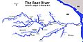
The Southeast Minnesota Root River and its major branches

