
Sand Hill River facts for kids
Quick facts for kids Sand Hill River |
|
|---|---|
 |
|
| Country | United States |
| State | Minnesota |
| Region | Northwestern Minnesota |
| City | Rindal, Fertile, Climax |
| Physical characteristics | |
| Main source | Sand Hill Lake Near Fertile, MN |
| River mouth | Red River of the North Climax, MN |
| Length | 101 mi (163 km) |
| Basin features | |
| Basin size | 475 sq mi (1,230 km2) |
The Sand Hill River is a river in northwestern Minnesota, United States. It flows for about 101 miles (163 km). This river is a small stream that flows into a larger one, which is called the Red River of the North.
The Sand Hill River is part of a huge water system. Its waters eventually reach Hudson Bay in Canada. This happens because the Sand Hill River flows into the Red River, which then flows into Lake Winnipeg. From Lake Winnipeg, the water travels through the Nelson River all the way to Hudson Bay. The area of land that drains water into the Sand Hill River is about 475 square miles (1,230 km²).
The river got its name from the sandy hills found near the end of its journey.
River's Journey
The Sand Hill River starts from Sand Hill Lake. This lake is located near the town of Fosston in Polk County. From there, the river generally flows towards the west.
As it travels, the river dips south for a bit. It passes through Mahnomen County and Norman County. Then, it returns to Polk County. Along its path, the river flows past the towns of Rindal, Fertile, and Climax. Finally, the Sand Hill River flows into the Red River of the North. This meeting point is about 2 miles (3.2 km) west of Climax.
Images for kids
-
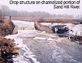
A structure on the Sand Hill River that helps control water flow.

