
Pomme de Terre River (Minnesota) facts for kids
Quick facts for kids Pomme de Terre River |
|
|---|---|

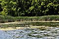
The Pomme de Terre River in Appleton in 2007
|
|
 |
|
| Country | United States |
| State | Minnesota |
| Physical characteristics | |
| Main source | Stalker Lake Tordenskjold Township, Otter Tail County 1,283 ft (391 m) 46°11′55″N 95°51′20″W / 46.19861°N 95.85556°W |
| River mouth | Minnesota River Appleton Township, Swift County 935 ft (285 m) 45°10′33″N 96°05′13″W / 45.17583°N 96.08694°W |
| Length | 124.5 mi (200.4 km) |
| Basin features | |
| Basin size | 875 sq mi (2,270 km2) |
The Pomme de Terre River is a river about 125 miles (201 km) long in western Minnesota, United States. It flows into the Minnesota River, which then joins the Mississippi River. This means the Pomme de Terre River is part of the huge Mississippi River system. It drains an area of about 875 square miles (2,266 km²), mostly farmland. The very beginning of the Pomme de Terre River is the northernmost point of the Minnesota River's entire water system.
Contents
What's in a Name?
The name Pomme de Terre comes from the French language. It literally means "soil apple." This phrase usually refers to a potato.
However, in this case, early French explorers named the river after a different root vegetable. It was named for the potato-like prairie turnip. The Sioux people often ate this plant.
River's Journey
The Pomme de Terre River starts at Stalker Lake. This lake is located in Tordenskjold Township. It's about three miles (5 km) northeast of Dalton in southern Otter Tail County.
The river generally flows south. It passes through eastern Grant and Stevens Counties. It also flows through western Swift County. Along its way, it goes through the cities of Barrett, Morris, and Appleton.
The river ends by flowing into Marsh Lake. Marsh Lake is on the Minnesota River in southwestern Swift County. It's about four miles (6 km) southwest of Appleton. Marsh Lake was formed when water backed up because of the Pomme de Terre's delta. Today, a man-made dam helps keep the lake's water level steady.
River's Path and Surroundings
In its upper part, the river flows through an area with many lakes. This area was shaped by glaciers. The river's path here has meadows and wooded hills. There are also marshy areas where the river flows through lakes.
Some of the biggest lakes on the river include Ten Mile Lake in Otter Tail County. There are also Pomme de Terre and Barrett Lakes in Grant County. Perkins Lake is another large lake in Stevens County. Small dams help control the water levels of several lakes along the river.
Downstream from Morris, the river flows over flat plains. Its banks are eroding, and the water becomes more cloudy or turbid.
Land Use Around the River
The Minnesota Pollution Control Agency reports that about 81% of the land around the Pomme de Terre River is used for farming. Of this farmland, half is used to grow corn and soybeans. The other 43% is used for hay and small grains.
How Fast Does the River Flow?
The United States Geological Survey measures the river's flow at Appleton. This spot is eight miles (13 km) upstream from where the river meets the Minnesota River.
Between 1931 and 2005, the river's average flow was 132 cubic feet per second (4 m³/s). The fastest flow ever recorded was 8,890 cubic feet per second (252 m³/s). This happened on April 7, 1997, partly because a dam broke. There were also many days in some years when the river's flow was zero.
Images for kids
-
The source of the Pomme de Terre at Stalker Lake.

See also
 In Spanish: Río Pomme de Terre (Minnesota) para niños
