
Des Moines River facts for kids
Quick facts for kids Des Moines River |
|
|---|---|

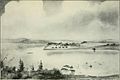
The Des Moines River upstream of Ottumwa, Iowa
|
|

The Des Moines River watershed
|
|
| Country | United States |
| State | Iowa, Minnesota, Missouri |
| Physical characteristics | |
| Main source | Lake Shetek Murray County, Minnesota 1,483 ft (452 m) 44°05′02″N 95°41′17″W / 44.0839°N 95.6881°W |
| River mouth | Mississippi River Clark County, Missouri / Lee County, Iowa, near Keokuk, Iowa 597 ft (182 m) 40°22′52″N 91°25′21″W / 40.3812°N 91.4224°W |
| Length | 525 mi (845 km) |
| Width |
|
| Basin features | |
| Basin size | 14,802 sq mi (38,340 km2) |
The Des Moines River is a very important river in the central United States. It's about 525 miles (845 km) long. This makes it the longest river flowing through the state of Iowa! It starts in southern Minnesota and flows all the way across Iowa. It goes from the flat plains into some hilly areas. The capital city of Des Moines is even named after this river. The river then flows into the mighty Mississippi River.
The Des Moines River also forms a small part of the border between Iowa and Missouri. A big highway called the Avenue of the Saints crosses over this part of the river. This highway connects St. Paul, Minnesota to St. Louis, Missouri.
Contents
Where the River Flows
The Des Moines River actually starts in two main parts, like two arms reaching out. These are called forks.
The West Fork
The West Fork is the main part of the river. It begins at Lake Shetek in Murray County, Minnesota. From there, it flows south and southeast. It passes by towns like Estherville, Iowa.
The East Fork
The East Fork starts at Okamanpeedan Lake. This lake is right on the border between Iowa and Minnesota. This fork flows south through a town called Algona, Iowa.
Where the Forks Meet
The two forks join together in southern Humboldt County, Iowa. This is about 5 miles (8 km) south of Humboldt, Iowa. After they meet, the river flows south through Fort Dodge, Iowa. It then goes through Ledges State Park. The river flows right through downtown Des Moines. Then it turns southeast, passing through Ottumwa, Iowa. Finally, it forms about 20 miles (32 km) of the border between Iowa and Missouri. It then joins the Mississippi River near Keokuk, Iowa.
Other Rivers Joining In
The Des Moines River has other rivers that flow into it. The Boone River joins it from the northeast, southwest of Fort Dodge. The Raccoon River joins it from the west in the city of Des Moines.
Lakes on the River
There are also two large lakes created by dams on the Des Moines River. Above the city of Des Moines, the river is dammed to create Saylorville Lake. Further downstream, near Pella, Iowa, the river is dammed again to create Lake Red Rock.
River History and Names

The Des Moines River has had many names over time. Early French explorers made maps of the area. One map from 1703 called it "R. des Otentas," which means "River of the Otoe". The Otoe Tribe lived in Iowa during the 1700s.
Native American Names
The Meskwaki and Sauk people called the river "Ke-o-shaw-qua". This means "Hermit's River". The town of Keosauqua, Iowa gets its name from this. The Dakota Indians lived near the river's start in Minnesota. They called it "Inyan Shasha" in their language. Another Dakota name was "Eah-sha-wa-pa-ta", or "Red Stone" river. This might refer to the reddish rocks near Red Rock.
Origin of "Des Moines"
The exact reason for the name Des Moines is not fully known. Early French explorers called it La Rivière des Moines. This literally means "River of the Monks." Some people think it referred to early monks who built small huts near where the river meets the Mississippi.
Another idea is that Moines was a shorter way of saying Moingouena. This was a group of Native Americans related to the Illinois people. A map from 1718 labels it as "le Moingona R."
River Transportation
In the mid-1800s, the Des Moines River was very important for travel and trade. Boats used the river to move goods and people across Iowa. However, by the 1860s, railroads started to be built. Trains soon took over as the main way to transport things.
River Flooding

The Des Moines River has a history of flooding, especially during certain seasons. When there is a lot of rain or snowmelt, the river can overflow its banks.
Past Floods
In May 1944, a park called Riverview Park had just opened. But on May 23, the river's protective wall, called a levee, started to break. The river quickly flooded the park and the areas around it.
A very big flood happened in the summer of 1993. This was part of the Great Flood of 1993. The Des Moines River and its branch, the Raccoon River, flooded much of the city of Des Moines. Many people had to leave their homes. In June 2008, officials asked people in downtown Des Moines to leave their homes again. This was because the river had reached flood levels. The mayor said they wanted to keep everyone safe.
Cities and Towns Along the River
Many cities and towns are located along the Des Moines River and its forks:
- Algona, Iowa (East Fork)
- Armstrong, Iowa (East Fork)
- Bonaparte, Iowa
- Bradgate, Iowa (West Fork)
- Chillicothe, Iowa
- Currie, Minnesota
- Dakota City, Iowa (East Fork)
- Des Moines, Iowa
- Douds, Iowa
- Eddyville, Iowa
- Eldon, Iowa
- Emmetsburg, Iowa (West Fork)
- Estherville, Iowa (West Fork)
- Farmington, Iowa
- Fort Dodge, Iowa
- Fraser, Iowa
- Graettinger, Iowa (West Fork)
- Humboldt, Iowa (West Fork)
- Irvington, Iowa (East Fork)
- Jackson, Minnesota
- Johnston, Iowa
- Keokuk, Iowa
- Keosauqua, Iowa
- Leando, Iowa
- Lehigh, Iowa
- Livermore, Iowa (East Fork)
- Ottumwa, Iowa
- Petersburg, Minnesota (West Fork)
- Rutland, Iowa (West Fork)
- St. Joseph, Iowa (East Fork)
- Windom, Minnesota

Other Names for the River
The Des Moines River has been known by several other names throughout history. These names are recorded in the Geographic Names Information System:
- La Riviere des Moins
- Le Moine River
- Monk River
- Nadouessioux River
- Outontantes River
- River Demoin
- River of the Maskoutens
- River of the Peouareas
Images for kids
-
A flood in Des Moines in 1851
-
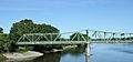
A railroad bridge over the Des Moines River near where it meets the Mississippi


See also
 In Spanish: Río Des Moines para niños
