Armstrong, Iowa facts for kids
Quick facts for kids
Armstrong, Iowa
|
|
|---|---|

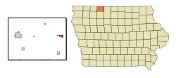
Location of Armstrong, Iowa
|
|
| Country | |
| State | |
| County | Emmet |
| Area | |
| • Total | 0.88 sq mi (2.29 km2) |
| • Land | 0.88 sq mi (2.29 km2) |
| • Water | 0.00 sq mi (0.00 km2) |
| Elevation | 1,250 ft (381 m) |
| Population
(2020)
|
|
| • Total | 875 |
| • Density | 989.82/sq mi (382.17/km2) |
| Time zone | UTC-6 (Central (CST)) |
| • Summer (DST) | UTC-5 (CDT) |
| ZIP code |
50514
|
| Area code(s) | 712 |
| FIPS code | 19-02935 |
| GNIS feature ID | 0454236 |
Armstrong is a city in Emmet County, Iowa, United States. In 2020, about 875 people lived there. It was first known as Armstrong Grove.
Contents
History of Armstrong
Armstrong began in 1892. This was after a railroad was built through the area. The city is named after Thomas Armstrong. He was one of the first people to arrive in this area. He came to trap animals near the West Fork Des Moines River. He only stayed for one winter because it was too cold.
In 1892, the first train arrived in Armstrong. Just one year later, in 1893, the town of Armstrong officially became a city.
Geography of Armstrong
Armstrong is located in the state of Iowa. Its exact spot is 43°23′45″N 94°28′51″W / 43.39583°N 94.48083°W.
The United States Census Bureau says the city covers about 0.88 square miles (2.29 square kilometers). All of this area is land.
Population and People
| Historical populations | ||
|---|---|---|
| Year | Pop. | ±% |
| 1900 | 907 | — |
| 1910 | 586 | −35.4% |
| 1920 | 818 | +39.6% |
| 1930 | 767 | −6.2% |
| 1940 | 937 | +22.2% |
| 1950 | 943 | +0.6% |
| 1960 | 958 | +1.6% |
| 1970 | 1,061 | +10.8% |
| 1980 | 1,153 | +8.7% |
| 1990 | 1,025 | −11.1% |
| 2000 | 979 | −4.5% |
| 2010 | 926 | −5.4% |
| 2020 | 875 | −5.5% |
| Source: and Iowa Data Center Source: |
||
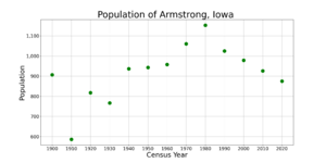
The population of Armstrong has changed over the years. The chart above shows how many people have lived there since 1900.
2020 Population Details
In 2020, the census counted 875 people living in Armstrong. There were 382 households in the city. A household is a group of people living together.
Most people in Armstrong were White (97.0%). About 2.2% of people were from two or more races. Less than 1% were Hispanic or Latino.
The average age in Armstrong was about 49.8 years old. This means half the people were younger and half were older. About 22.1% of residents were under 20 years old. Also, 32.6% were 65 years old or older. The city had slightly more females (51.2%) than males (48.8%).
2010 Population Details
The census in 2010 showed 926 people living in Armstrong. There were 403 households. The city had about 1052 people per square mile.
Most of the people were White (97.8%). A small number were Native American (0.4%) or Asian (0.4%). About 1.3% were from two or more races. About 0.6% of the population was Hispanic or Latino.
The average age was 49 years. About 20.8% of residents were under 18 years old. About 25.3% were 65 years or older. The city had slightly more females (50.6%) than males (49.4%).
Education in Armstrong
The North Union Community School District runs the public schools in Armstrong. This school district was created on July 1, 2014. It was formed when two older school districts, Armstrong–Ringsted and Sentral, joined together. The Armstrong and Ringsted school districts had already joined in 1979.
See also
 In Spanish: Armstrong (Iowa) para niños


