Emmet County, Iowa facts for kids
Quick facts for kids
Emmet County
|
|
|---|---|

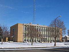
Emmet County Courthouse
|
|

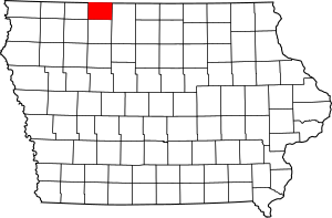
Location within the U.S. state of Iowa
|
|
 Iowa's location within the U.S. |
|
| Country | |
| State | |
| Founded | 1851 |
| Named for | Robert Emmet |
| Seat | Estherville |
| Largest city | Estherville |
| Area | |
| • Total | 408 sq mi (1,060 km2) |
| • Land | 401.4 sq mi (1,040 km2) |
| • Water | 6.6 sq mi (17 km2) 1.6% |
| Population
(2020)
|
|
| • Total | 9,388 |
| • Density | 23.010/sq mi (8.884/km2) |
| Time zone | UTC−6 (Central) |
| • Summer (DST) | UTC−5 (CDT) |
| Congressional district | 4th |
Emmet County is a county located in the state of Iowa, in the United States. In 2020, about 9,388 people lived here. The main city and county seat (where the county government is) is Estherville.
Contents
History of Emmet County
The Iowa Legislature officially created Emmet County in 1851. However, there weren't enough people living there to fully organize the county until 1859.
The county was named after Robert Emmet. He was a brave Irish patriot who fought for Ireland's freedom. He was very young, only 25, when he died for his beliefs.
Geography of Emmet County
Emmet County covers a total area of about 403 square miles. Most of this area, about 396 square miles, is land. The rest, about 6.6 square miles, is water.
It is one of the smaller counties in Iowa. It ranks as the second-smallest county by land area. It is also the fourth-smallest county when you count both land and water.
Main Roads in Emmet County
These are the most important roads that go through Emmet County:
Neighboring Counties
Emmet County shares its borders with these other counties:
- Jackson County, Minnesota (to the northwest)
- Martin County, Minnesota (to the northeast)
- Kossuth County (to the east)
- Palo Alto County (to the south)
- Dickinson County (to the west)
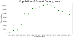
Emmet County Population Data
| Historical population | |||
|---|---|---|---|
| Census | Pop. | %± | |
| 1860 | 105 | — | |
| 1870 | 1,392 | 1,225.7% | |
| 1880 | 1,550 | 11.4% | |
| 1890 | 4,274 | 175.7% | |
| 1900 | 9,936 | 132.5% | |
| 1910 | 9,816 | −1.2% | |
| 1920 | 12,627 | 28.6% | |
| 1930 | 12,856 | 1.8% | |
| 1940 | 13,406 | 4.3% | |
| 1950 | 14,102 | 5.2% | |
| 1960 | 14,871 | 5.5% | |
| 1970 | 14,009 | −5.8% | |
| 1980 | 13,336 | −4.8% | |
| 1990 | 11,569 | −13.2% | |
| 2000 | 11,027 | −4.7% | |
| 2010 | 10,302 | −6.6% | |
| 2020 | 9,388 | −8.9% | |
| 2023 (est.) | 9,229 | −10.4% | |
| U.S. Decennial Census 1790-1960 1900-1990 1990-2000 2010-2018 |
|||
2020 Census Information
The 2020 census showed that 9,388 people lived in Emmet County. This means there were about 23 people per square mile.
Most people (94.84%) identified as being of one race. About 79.56% were non-Hispanic White. Other groups included Black people (0.98%), Hispanic people (9.45%), Native Americans (0.58%), and Asian people (0.34%). Some people identified as other races or more than one race.
There were 4,475 homes in the county. About 3,972 of these homes were lived in.
2010 Census Information
In 2010, the population of Emmet County was 10,302 people. There were 4,758 homes, and 4,236 of them were occupied.
Towns and Communities
Emmet County has several cities and smaller communities.
Cities in Emmet County
Unincorporated Communities
These are smaller places that are not officially organized as cities:
- Forsyth
- Gridley
- Hoprig
- Huntington
- Island Grove
- Maple Hill
- Raleigh
Townships
Emmet County is divided into twelve areas called townships. These are local government areas:
- Armstrong Grove
- Center
- Denmark
- Ellsworth
- Emmet
- Estherville
- High Lake
- Iowa Lake
- Jack Creek
- Lincoln
- Swan Lake
- Twelve Mile Lake
City Population Ranking
This table shows the cities in Emmet County listed by their population from the 2010 census.
† county seat
| Rank | City/Town/etc. | Municipal type | Population (2010 Census) |
|---|---|---|---|
| 1 | † Estherville | City | 6,360 |
| 2 | Armstrong | City | 926 |
| 3 | Ringsted | City | 422 |
| 4 | Wallingford | City | 197 |
| 5 | Gruver | City | 94 |
| 6 | Dolliver | City | 66 |
See also
 In Spanish: Condado de Emmet (Iowa) para niños


