Gruver, Iowa facts for kids
Quick facts for kids
Gruver, Iowa
|
|
|---|---|

Location of Gruver, Iowa
|
|
| Country | |
| State | |
| County | Emmet |
| Area | |
| • Total | 0.13 sq mi (0.33 km2) |
| • Land | 0.13 sq mi (0.33 km2) |
| • Water | 0.00 sq mi (0.00 km2) |
| Elevation | 1,302 ft (397 m) |
| Population
(2020)
|
|
| • Total | 63 |
| • Density | 496.06/sq mi (192.22/km2) |
| Time zone | UTC-6 (Central (CST)) |
| • Summer (DST) | UTC-5 (CDT) |
| ZIP code |
51344
|
| Area code(s) | 712 |
| FIPS code | 19-33240 |
| GNIS feature ID | 0457174 |
Gruver is a small city located in Emmet County, Iowa, in the United States. It is a quiet place with a small population. According to the 2020 census, only 63 people lived there.
| Top - 0-9 A B C D E F G H I J K L M N O P Q R S T U V W X Y Z |
History of Gruver
Gruver was first planned out in the year 1899. When it was first created, the town had a different name: Luzon. However, just one year later, in 1900, its name was changed to Gruver.
Geography of Gruver
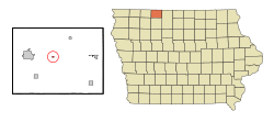
Gruver is located in the state of Iowa. Its exact position on a map is 43°23′35″N 94°42′17″W / 43.39306°N 94.70472°W. This means it is at 43.393113 degrees north latitude and -94.704719 degrees west longitude.
The city is quite small in terms of land area. The United States Census Bureau reports that Gruver covers a total area of about 0.33 square kilometers (or 0.13 square miles). All of this area is land, meaning there are no large bodies of water like lakes or rivers within the city limits.
Population and People in Gruver
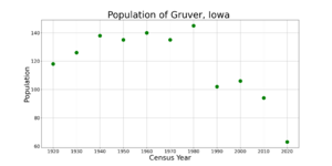
Gruver has seen its population change over the years. You can see how the number of people living there has changed in the table and chart below.
| Historical populations | ||
|---|---|---|
| Year | Pop. | ±% |
| 1920 | 118 | — |
| 1930 | 126 | +6.8% |
| 1940 | 138 | +9.5% |
| 1950 | 135 | −2.2% |
| 1960 | 140 | +3.7% |
| 1970 | 135 | −3.6% |
| 1980 | 145 | +7.4% |
| 1990 | 102 | −29.7% |
| 2000 | 106 | +3.9% |
| 2010 | 94 | −11.3% |
| 2020 | 63 | −33.0% |
| Source: and Iowa Data Center Source: |
||
Gruver's Population in 2020
In 2020, the census showed that 63 people lived in Gruver. These people lived in 29 different households, and 21 of these were families.
The city had about 192 people per square kilometer (or 498 people per square mile). There were 32 housing units in total. Most residents were White.
About 19% of the people were under 20 years old. Around 30% were 65 years or older. The average age in Gruver was about 55.5 years. Slightly more than half of the residents (55.6%) were male, and 44.4% were female.
Gruver's Population in 2010
Back in 2010, Gruver had 94 residents. They lived in 38 households, and 24 of these were families. The population density was higher then, with about 279 people per square kilometer (or 723 people per square mile).
About 31.6% of households had children under 18 living with them. Many households (50%) were married couples. The average age was younger in 2010, at 32.5 years. About 28.7% of residents were under 18. The gender split was similar to 2020, with 55.3% male and 44.7% female.
Education in Gruver
Students in Gruver attend public schools operated by the Estherville–Lincoln Central Community School District. This school district was formed on July 1, 1997. It was created when the Estherville and Lincoln Central school districts joined together.
See also
 In Spanish: Gruver (Iowa) para niños
 | Audre Lorde |
 | John Berry Meachum |
 | Ferdinand Lee Barnett |


