Kossuth County, Iowa facts for kids
Quick facts for kids
Kossuth County
|
|
|---|---|

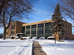
Kossuth County Courthouse
|
|

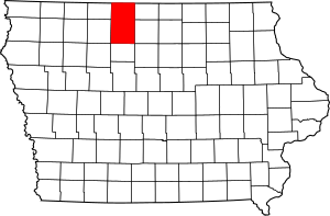
Location within the U.S. state of Iowa
|
|
 Iowa's location within the U.S. |
|
| Country | |
| State | |
| Founded | January 15, 1851 |
| Named for | Lajos Kossuth |
| Seat | Algona |
| Largest city | Algona |
| Area | |
| • Total | 974 sq mi (2,520 km2) |
| • Land | 973 sq mi (2,520 km2) |
| • Water | 1.6 sq mi (4 km2) 0.2% |
| Population
(2020)
|
|
| • Total | 14,828 |
| • Density | 15/sq mi (6/km2) |
| Time zone | UTC−6 (Central) |
| • Summer (DST) | UTC−5 (CDT) |
| Congressional district | 4th |
Kossuth County (pronounced kə-SOOTH) is a county in the state of Iowa. It is located in the U.S. state of Iowa. In 2020, about 14,828 people lived here. The main city and county seat is Algona.
Contents
History of Kossuth County
Kossuth County was created on January 15, 1851. It was named after Lajos Kossuth. He was a very important leader from Hungary. He had to leave his home country and came to America. This happened after Hungary fought for its freedom from the Habsburg Dynasty.
In 1857, Kossuth County became bigger. It added land from what used to be Bancroft County. There were also tries to make new counties from this area. One was called Crocker County, but it was too small. Another try in 1914 for a county called Larrabee County also did not work out.
Geography of Kossuth County
Kossuth County covers a large area. It is about 974 square miles big. Most of this (973 square miles) is land. Only a small part (1.6 square miles) is water. This makes it the largest county in Iowa by land area.
Main Roads in Kossuth County
Neighboring Counties
Kossuth County shares borders with several other counties:
- Martin County, Minnesota (to the north)
- Faribault County, Minnesota (to the north)
- Winnebago County (to the northeast)
- Hancock County (to the southeast)
- Humboldt County (to the south)
- Palo Alto County (to the southwest)
- Emmet County (to the northwest)
Protected Natural Areas
- Union Slough National Wildlife Refuge is a special place in the county. It protects wildlife and their homes.
People and Population
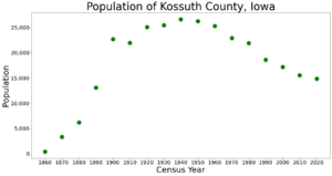
| Historical population | |||
|---|---|---|---|
| Census | Pop. | %± | |
| 1860 | 416 | — | |
| 1870 | 3,351 | 705.5% | |
| 1880 | 6,178 | 84.4% | |
| 1890 | 13,120 | 112.4% | |
| 1900 | 22,720 | 73.2% | |
| 1910 | 21,971 | −3.3% | |
| 1920 | 25,082 | 14.2% | |
| 1930 | 25,452 | 1.5% | |
| 1940 | 26,630 | 4.6% | |
| 1950 | 26,241 | −1.5% | |
| 1960 | 25,314 | −3.5% | |
| 1970 | 22,937 | −9.4% | |
| 1980 | 21,891 | −4.6% | |
| 1990 | 18,591 | −15.1% | |
| 2000 | 17,163 | −7.7% | |
| 2010 | 15,543 | −9.4% | |
| 2020 | 14,828 | −4.6% | |
| 2023 (est.) | 14,396 | −7.4% | |
| U.S. Decennial Census 1790-1960 1900-1990 1990-2000 2010-2018 |
|||
2020 Census Information
In 2020, the census counted 14,828 people living in Kossuth County. This means there were about 15 people per square mile. Most people (96.53%) said they belonged to one race. There were 7,216 homes, and 6,438 of them were lived in.

| Race | Number of People | Percentage |
|---|---|---|
| White (not Hispanic) | 13,758 | 92.8% |
| Black or African American (not Hispanic) | 71 | 0.47% |
| Native American (not Hispanic) | 9 | 0.06% |
| Asian (not Hispanic) | 71 | 0.47% |
| Pacific Islander (not Hispanic) | 3 | 0.02% |
| Other/Mixed (not Hispanic) | 313 | 2.11% |
| Hispanic or Latino | 603 | 4.1% |
2010 Census Information
The 2010 census showed that 15,543 people lived in the county. There were 7,486 homes, and 6,697 of them were lived in.
Special Population Areas
The United States Census Bureau groups some rural areas together. These are called "Census-designated places." They help with population studies.
Cities and Towns by Size
This table shows the biggest cities and towns in Kossuth County based on the 2020 census.
† This means it is the county seat, the main city.
| Rank | City/Town/etc. | Type | Population (2020 Census) |
|---|---|---|---|
| 1 | † Algona | City | 5,487 |
| 2 | Bancroft | City | 699 |
| 3 | Swea City | City | 566 |
| 4 | Titonka | City | 511 |
| 5 | Whittemore | City | 497 |
| 6 | Burt | City | 418 |
| 7 | Wesley | City | 391 |
| 8 | Fenton | City | 271 |
| 9 | Lakota | City | 267 |
| 10 | Lu Verne (partially in Humboldt County) | City | 228 (258 total) |
| 11 | Lone Rock | City | 146 |
| 12 | Ledyard | City | 121 |
| 13 | St. Joseph | CDP | 51 |
| 14 | Sexton | CDP | 46 |
| 15 | Irvington | CDP | 36 |
| 16 | St. Benedict | CDP | 31 |
| 17 | West Bend (mostly in Palo Alto County) | City | 19 (791 total) |
Communities in Kossuth County
Cities
Villages and Hamlets
- German Valley
Education in Kossuth County
Here are the school districts that serve students in Kossuth County:
- Algona Community School District
- North Union Community School District
- North Iowa Community School District
- North Kossuth Community School District
- Twin Rivers Community School District
- West Bend-Mallard Community School District
Past School Districts
Some school districts have changed over time:
- Corwith-Wesley Community School District closed on July 1, 2015.
- Lu Verne Community School District joined Algona CSD on July 1, 2023.
- Sentral Community School District joined North Union CSD on July 1, 2014.
- Titonka Consolidated School District joined Algona CSD on July 1, 2014.
See also
 In Spanish: Condado de Kossuth para niños
 | Delilah Pierce |
 | Gordon Parks |
 | Augusta Savage |
 | Charles Ethan Porter |


