Lu Verne, Iowa facts for kids
Quick facts for kids
Lu Verne, Iowa
|
|
|---|---|

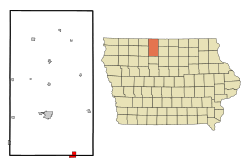
Location of Lu Verne, Iowa
|
|
| Country | |
| State | |
| Counties | Kossuth, Humboldt |
| Area | |
| • Total | 2.12 sq mi (5.50 km2) |
| • Land | 2.12 sq mi (5.50 km2) |
| • Water | 0.00 sq mi (0.00 km2) |
| Elevation | 1,145 ft (349 m) |
| Population
(2020)
|
|
| • Total | 258 |
| • Density | 121.47/sq mi (46.91/km2) |
| Time zone | UTC-6 (Central (CST)) |
| • Summer (DST) | UTC-5 (CDT) |
| ZIP code |
50560
|
| Area code(s) | 515 |
| FIPS code | 19-47370 |
| GNIS feature ID | 0458670 |
Lu Verne is a small city in Iowa, a state in the United States. It is unique because it is located in two different counties: Humboldt County and Kossuth County. In 2020, about 258 people lived in Lu Verne.
Contents
History of Lu Verne
Lu Verne was officially planned and marked out in 1880. It got its name from another city called Luverne, Minnesota, which is in Minnesota.
A long time ago, a road named Iowa Highway 408 used to serve Lu Verne. However, this road was removed from service in 1980.
Where is Lu Verne?
Lu Verne is located in Iowa. Its exact coordinates are 42.911638 degrees North and 94.083618 degrees West.
The United States Census Bureau says that the city covers a total area of about 2.26 square miles (5.85 square kilometers). All of this area is land, meaning there are no large lakes or rivers within the city limits.
People of Lu Verne
| Historical populations | ||
|---|---|---|
| Year | Pop. | ±% |
| 1900 | 534 | — |
| 1910 | 501 | −6.2% |
| 1920 | 610 | +21.8% |
| 1930 | 570 | −6.6% |
| 1940 | 576 | +1.1% |
| 1950 | 553 | −4.0% |
| 1960 | 468 | −15.4% |
| 1970 | 380 | −18.8% |
| 1980 | 418 | +10.0% |
| 1990 | 328 | −21.5% |
| 2000 | 299 | −8.8% |
| 2010 | 261 | −12.7% |
| 2020 | 258 | −1.1% |
| Source: and Iowa Data Center Source: |
||
The population of Lu Verne has changed over the years. In 1900, there were 534 people, and the population reached its highest in 1920 with 610 people. Since then, the number of residents has slowly decreased.
Population in 2020
In 2020, the census showed that 258 people lived in Lu Verne. These people lived in 101 households, and 63 of these were families. The city had about 121.5 people per square mile.
Most of the people in Lu Verne were White (91.1%). A small number were Black or African American (0.8%), Asian (0.4%), or from two or more races (6.6%). About 3.1% of the population was Hispanic or Latino.
Many households (36.6%) had children under 18 living with them. The average age of people in Lu Verne was 33.7 years old. About 28.7% of residents were under 20 years old, and 14.0% were 65 years or older. The city had a nearly even split of genders, with 50.8% male and 49.2% female residents.
Education in Lu Verne
Students in Lu Verne attend schools within the Algona Community School District.
Historically, Lu Verne had its own school district, called the Lu Verne Community School District. Since 2015, older students from Lu Verne (secondary students) have gone to schools in the Algona Community School District. This includes Algona Middle School and Algona High School. In 2023, the Lu Verne district officially joined the Algona Community School District.
Before 2015, from 1984, the Lu Verne district shared grades with the Corwith–Wesley Community School District. This partnership meant students attended Corwith–Wesley–Lu Verne High School.
See also
 In Spanish: Lu Verne para niños
 | Audre Lorde |
 | John Berry Meachum |
 | Ferdinand Lee Barnett |

