Lakota, Iowa facts for kids
Quick facts for kids
Lakota, Iowa
|
|
|---|---|

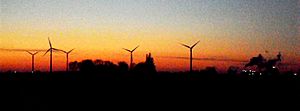
November sunset in Lakota, Iowa
|
|

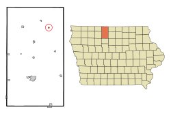
Location of Lakota, Iowa
|
|
| Country | |
| State | |
| County | Kossuth |
| Germania, Iowa | 1892 |
| Area | |
| • Total | 0.73 sq mi (1.89 km2) |
| • Land | 0.73 sq mi (1.89 km2) |
| • Water | 0.00 sq mi (0.00 km2) |
| Elevation | 1,142 ft (348 m) |
| Population
(2020)
|
|
| • Total | 267 |
| • Density | 366.26/sq mi (141.47/km2) |
| Time zone | UTC-6 (Central (CST)) |
| • Summer (DST) | UTC-5 (CDT) |
| ZIP code |
50451
|
| Area code(s) | 515 |
| FIPS code | 19-42825 |
| GNIS feature ID | 0458207 |
Lakota is a small city located in Kossuth County, Iowa, in the United States. In 2020, about 267 people lived there. Before 1919, this city had a different name: Germania.
Contents
History of Lakota
How Lakota Got Its Name
The city we know today as Lakota was first called Germania. It was officially mapped out and recorded on August 26, 1892. The first people to settle here were mostly from Germany, which is why they chose the name Germania.
Changing the Name During World War I
In 1918, during World War I, there was a lot of strong feeling against Germany across the United States. To avoid problems and show their loyalty, the people of Germania decided to change their town's name.
They held an election on October 1, 1918. Most people voted to change the name from Germania to Lakota. The mayor, J. Gus Thaves, officially filed the name change on October 16, 1918, at the Kossuth County Courthouse. The post office officially recognized the new name on August 5, 1919.
What Does Lakota Mean?
The new name, Lakota, comes from a Native American word. It has a few different meanings. Some people say Lakota means "beautiful prairie." Others believe it means "plenty" or "allies."
Geography of Lakota
Lakota is located in Iowa at specific coordinates: 43.377953 degrees North and 94.094274 degrees West.
The United States Census Bureau says that the city covers a total area of about 0.73 square miles (1.89 square kilometers). All of this area is land, with no water.
Population and People
| Historical populations | ||
|---|---|---|
| Year | Pop. | ±% |
| 1900 | 384 | — |
| 1910 | 436 | +13.5% |
| 1920 | 472 | +8.3% |
| 1930 | 409 | −13.3% |
| 1940 | 457 | +11.7% |
| 1950 | 443 | −3.1% |
| 1960 | 459 | +3.6% |
| 1970 | 385 | −16.1% |
| 1980 | 330 | −14.3% |
| 1990 | 281 | −14.8% |
| 2000 | 255 | −9.3% |
| 2010 | 255 | +0.0% |
| 2020 | 267 | +4.7% |
| Source: and Iowa Data Center Source: |
||
Lakota's Population in 2020
According to the 2020 census, 267 people lived in Lakota. There were 121 households and 75 families. The city had about 366 people per square mile.
Most of the people in Lakota were White (89.9%). A small number of people were Black or African American (0.7%), Asian (0.4%), or from two or more races (6.0%). About 8.6% of the population identified as Hispanic or Latino.
About 21.5% of households had children under 18 living with them. Many households (49.6%) were married couples. The average age of people in Lakota was 48.8 years old. About 24% of residents were under 20 years old, and 21.3% were 65 or older.
Lakota's Population in 2010
In the 2010 census, 255 people lived in Lakota. There were 119 households and 71 families. The population density was about 1342 people per square mile.
Most residents (94.1%) were White. About 5.9% of the population was Hispanic or Latino.
The average age in the city was 48.4 years. About 19.6% of residents were under 18, and 24.3% were 65 or older.
Education in Lakota
Students in Lakota attend schools within the North Iowa Community School District. This school district was created on July 1, 1996. It was formed when two other school districts, the Buffalo Center–Rake–Lakota Community School District and the Thompson Community School District, joined together.
Before that, on July 1, 1992, the Lakota Community School District had merged with the Buffalo Center–Rake Community School District to form the Buffalo Center–Rake–Lakota district.
Notable People from Lakota
Some well-known people have come from Lakota:
- Don I. Wortman – a leader in the federal government.
- Paul Ukena – a famous opera singer.
- Timothy Ley – a scientist who studies blood and cancer.
Gallery
See also
 In Spanish: Lakota (Iowa) para niños
 | James Van Der Zee |
 | Alma Thomas |
 | Ellis Wilson |
 | Margaret Taylor-Burroughs |


