
Hancock County, Iowa facts for kids
Quick facts for kids
Hancock County
|
|
|---|---|

Visitor kiosk at the 148 wind turbine farm
|
|

Location within the U.S. state of Iowa
|
|
 Iowa's location within the U.S. |
|
| Country | |
| State | |
| Founded | 1851 |
| Named for | John Hancock |
| Seat | Garner |
| Largest city | Garner |
| Area | |
| • Total | 573 sq mi (1,480 km2) |
| • Land | 571 sq mi (1,480 km2) |
| • Water | 2.0 sq mi (5 km2) 0.4% |
| Population
(2020)
|
|
| • Total | 10,795 |
| • Density | 18.839/sq mi (7.274/km2) |
| Time zone | UTC−6 (Central) |
| • Summer (DST) | UTC−5 (CDT) |
| Congressional district | 4th |
Hancock County is a county in the state of Iowa, USA. In 2020, about 10,795 people lived there. The main town, or county seat, is Garner.
Hancock County was started on January 15, 1851. It was named after John Hancock. He was a very important leader during the American Revolution. He was part of the Continental Congress.
Contents
Geography
Hancock County covers about 573 square miles. Most of this area, about 571 square miles, is land. The rest, about 2 square miles, is water.
Main Roads
These are the major highways that go through Hancock County:
 U.S. Highway 18
 U.S. Highway 69
 Iowa Highway 17
Neighboring Counties
Hancock County shares borders with these other counties:
- Winnebago County (to the north)
- Cerro Gordo County (to the east)
- Wright County (to the south)
- Kossuth County (to the west)
History
Hancock County was officially created after a special vote on June 28, 1858. Soon after, two areas called Avery and Madison were also formed. A courthouse was built in Garner, Iowa. Garner has been the county seat ever since.
Population Information
| Historical population | |||
|---|---|---|---|
| Census | Pop. | %± | |
| 1860 | 179 | — | |
| 1870 | 999 | 458.1% | |
| 1880 | 3,453 | 245.6% | |
| 1890 | 7,621 | 120.7% | |
| 1900 | 13,752 | 80.4% | |
| 1910 | 12,731 | −7.4% | |
| 1920 | 14,723 | 15.6% | |
| 1930 | 14,802 | 0.5% | |
| 1940 | 15,402 | 4.1% | |
| 1950 | 15,077 | −2.1% | |
| 1960 | 14,604 | −3.1% | |
| 1970 | 13,506 | −7.5% | |
| 1980 | 13,833 | 2.4% | |
| 1990 | 12,638 | −8.6% | |
| 2000 | 12,100 | −4.3% | |
| 2010 | 11,341 | −6.3% | |
| 2020 | 10,795 | −4.8% | |
| 2023 (est.) | 10,615 | −6.4% | |
| U.S. Decennial Census 1790-1960 1900-1990 1990-2000 2010-2018 |
|||

2020 Census Details
In 2020, the census counted 10,795 people living in Hancock County. This means there were about 19 people per square mile. Most people (95.32%) said they belonged to one race. There were 5,113 homes, and 4,585 of them were lived in.
Here's a quick look at the different groups of people in Hancock County:
| Group | Number | Percent |
|---|---|---|
| White | 9,813 | 91% |
| Black or African American | 76 | 0.7% |
| Native American | 22 | 0.2% |
| Asian | 25 | 0.23% |
| Pacific Islander | 0 | 0% |
| Other/Mixed | 245 | 2.3% |
| Hispanic or Latino | 614 | 5.7% |
Economy

In December 2008, the unemployment rate in Hancock County was 9.1%. This was a big jump from 4.0% in December 2007. By 2016, the unemployment rate had dropped back down to 2.2%. This means more people had jobs.
Communities
Hancock County has several cities and towns.
Cities
- Britt
- Corwith
- Crystal Lake
- Forest City (part of this city is in another county)
- Garner
- Goodell
- Kanawha
- Klemme
- Woden
Census-Designated Places
These are areas that are like towns but are not officially incorporated as cities:
Other Unincorporated Community
Townships
Hancock County is divided into sixteen smaller areas called townships:
- Amsterdam
- Avery
- Bingham
- Boone
- Britt
- Concord
- Crystal
- Ell
- Ellington
- Erin
- Garfield
- Liberty
- Madison
- Magor
- Orthel
- Twin Lake
Population Ranking of Communities
This table shows the communities in Hancock County from largest to smallest population, based on the 2020 census. † county seat
| Rank | City/Town/etc. | Type | Population (2020 Census) |
|---|---|---|---|
| 1 | Forest City (partially in Winnebago County) | City | 4,285 |
| 2 | † Garner | City | 3,065 |
| 3 | Britt | City | 2,044 |
| 4 | Kanawha | City | 658 |
| 5 | Klemme | City | 441 |
| 6 | Corwith | City | 266 |
| 7 | Crystal Lake | City | 253 |
| 8 | Woden | City | 188 |
| 9 | Goodell | City | 140 |
| 10 | Duncan | CDP | 57 |
| 11 | Miller | CDP | 50 |
| 12 | Hayfield | CDP | 41 |
| 13 | Hutchins | CDP | 22 |
Education
Many different school districts serve the students in Hancock County:
- Algona Community School District
- Belmond-Klemme Community School District
- Clarion-Goldfield-Dows Community School District
- Forest City Community School District
- Garner-Hayfield-Ventura Community School District
- West Fork Community School District
- West Hancock Community School District
Some school districts that used to be in the area have since joined with others:
- Corwith-Wesley Community School District (joined with others in 2015)
- Lu Verne Community School District (joined Algona CSD in 2023)
- Sheffield Chapin Meservey Thornton Community School District (SCMT) (joined West Fork CSD in 2011)
- Titonka Consolidated School District (joined Algona CSD in 2014)
- Ventura Community School District (joined Garner-Hayfield-Ventura in 2015)
- Woden-Crystal Lake Community School District (joined Forest City in 2013, with some parts going to West Fork)
Images for kids
-
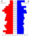
This population pyramid shows the age and gender groups in Hancock County in 2022.

See also
 In Spanish: Condado de Hancock (Iowa) para niños
