Titonka, Iowa facts for kids
Quick facts for kids
Titonka, Iowa
|
|
|---|---|
| Nickname(s):
"Big Black"
|
|
| Motto(s):
"Proud Of Our Heritage, Committed To Our Future"
|
|

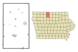
Location of Titonka, Iowa
|
|
| Country | |
| State | |
| County | Kossuth |
| Area | |
| • Total | 0.28 sq mi (0.73 km2) |
| • Land | 0.28 sq mi (0.73 km2) |
| • Water | 0.00 sq mi (0.00 km2) |
| Elevation | 1,161 ft (354 m) |
| Population
(2020)
|
|
| • Total | 511 |
| • Density | 1,812.06/sq mi (699.48/km2) |
| Time zone | UTC-6 (Central (CST)) |
| • Summer (DST) | UTC-5 (CDT) |
| ZIP code |
50480
|
| Area code(s) | 515 |
| FIPS code | 19-78330 |
| GNIS feature ID | 0462264 |
| Website | City of Titonka, Iowa Website |
Titonka is a small city located in Kossuth County, Iowa, in the United States. It is a friendly community known for its history and local charm. In 2020, the city had a population of 511 people.
Contents
History of Titonka
Titonka began its journey in 1898. This was after the Burlington, Cedar Rapids and Northern Railway built train tracks through the area. The name "Titonka" comes from the Sioux language. It means "big black (buffalo)". The city officially became a city on February 1, 1898.
Geography and Location
Titonka is located at coordinates 43°14′12″N 94°2′31″W / 43.23667°N 94.04194°W. This means it is in the northern part of Iowa. The city covers a total area of about 0.28 square miles (0.73 square kilometers). All of this area is land, with no large bodies of water inside the city limits.
Population and People
| Historical populations | ||
|---|---|---|
| Year | Pop. | ±% |
| 1900 | 224 | — |
| 1910 | 278 | +24.1% |
| 1920 | 418 | +50.4% |
| 1930 | 473 | +13.2% |
| 1940 | 574 | +21.4% |
| 1950 | 589 | +2.6% |
| 1960 | 647 | +9.8% |
| 1970 | 599 | −7.4% |
| 1980 | 658 | +9.8% |
| 1990 | 612 | −7.0% |
| 2000 | 584 | −4.6% |
| 2010 | 476 | −18.5% |
| 2020 | 511 | +7.4% |
| Source: and Iowa Data Center Source: |
||
Titonka's Population in 2020
In 2020, Titonka had 511 residents living in 211 households. About 28% of these households had children under 18. Most residents, about 95.9%, were White. The city's population density was about 1,810 people per square mile. The average age of people in Titonka was 41.4 years.
- 26.2% of residents were under 20 years old.
- 24.9% of residents were 65 years or older.
- The population was almost evenly split between males (51.7%) and females (48.3%).
Titonka's Population in 2010
Back in 2010, Titonka had 476 people. There were 223 households in the city. The population density was about 1,700 people per square mile. Most of the residents (98.7%) were White. The average age was 52.4 years.
- 20.4% of residents were under 18.
- 34% of residents were 65 or older.
- The city had more females (54%) than males (46%).
Education in Titonka
Students in Titonka attend schools within the Algona Community School District. This district includes Algona High School. Before 2014, Titonka had its own school district called the Titonka Consolidated School District. However, on July 1, 2014, it joined with the Algona district. The Algona district then took over the Titonka school building.
See also
 In Spanish: Titonka (Iowa) para niños
 | James B. Knighten |
 | Azellia White |
 | Willa Brown |

