Eddyville, Iowa facts for kids
Quick facts for kids
Eddyville, Iowa
|
|
|---|---|

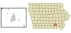
Location of Eddyville, Iowa
|
|
| Country | |
| State | |
| Counties | Wapello, Mahaska, Monroe |
| Area | |
| • Total | 1.16 sq mi (3.00 km2) |
| • Land | 1.16 sq mi (3.00 km2) |
| • Water | 0.00 sq mi (0.00 km2) |
| Elevation | 676 ft (206 m) |
| Population
(2020)
|
|
| • Total | 970 |
| • Density | 838.38/sq mi (323.71/km2) |
| Time zone | UTC-6 (Central (CST)) |
| • Summer (DST) | UTC-5 (CDT) |
| ZIP code |
52553
|
| Area code(s) | 641 |
| FIPS code | 19-23970 |
| GNIS feature ID | 2394613 |
Eddyville is a small city in Iowa, a state in the United States. It's special because it sits where three different counties meet: Mahaska, Monroe, and Wapello counties. In 2020, about 970 people lived there.
Contents
History of Eddyville
Around 1839, a village of the Sauk Native American tribe was built here. It was named after their chief, Chief Hard Fish. In 1840 or 1841, a man named Jabish P. Eddy was allowed to open a trading post in the village. This was a place where people could trade goods and pioneers could cross the Des Moines River.
In 1842, the land became part of the United States, and the Sauk people moved away. J.P. Eddy then helped set up the town, which was named Eddyville after him. In 1843, more settlers came to the area. Eddyville officially became a town in 1857.
The first coal mines in the area opened near Eddyville. People in town say that a house once helped enslaved people find freedom. This was part of the Underground Railroad, a secret network that helped people escape slavery before the Civil War.
Eddyville was once a busy railroad town. Trains helped move goods and people. Later, some of these old train lines were closed. However, one line was rebuilt to serve large companies like Cargill.
Over the years, Eddyville's schools grew. What started as one building for all grades became bigger. Eventually, Eddyville's school district joined with nearby towns like Hedrick, Fremont, and Blakesburg to form a larger school system.
The city also developed important services. After World War II, Eddyville built a public water system. The volunteer fire department grew over time, getting new trucks and training. They even helped set up a model ambulance service for the state. The city also built a sewer system to keep the town clean.
The Des Moines River has always been a big part of Eddyville's life. The town has faced major floods, but the Army Corps of Engineers built levees (protective walls) to help keep the city safe.
A new bridge was built across the river after World War II. This helped connect Eddyville to a new power plant, which later became the large Cargill plant you see today.
Geography of Eddyville
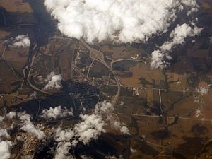
Eddyville is located on the east side of a curve in the Des Moines River. It's about 70 miles south of Des Moines and 15 miles north of Ottumwa.
As mentioned, Eddyville is unique because it's located in three different counties at once! The city covers parts of Wapello, Mahaska, and Monroe counties. The city covers about 1.18 square miles (3.00 square kilometers) of land.
People of Eddyville (Demographics)
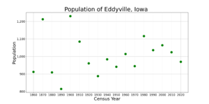
| Historical populations | ||
|---|---|---|
| Year | Pop. | ±% |
| 1860 | 912 | — |
| 1870 | 1,212 | +32.9% |
| 1880 | 909 | −25.0% |
| 1890 | 815 | −10.3% |
| 1900 | 1,230 | +50.9% |
| 1910 | 1,085 | −11.8% |
| 1920 | 961 | −11.4% |
| 1930 | 888 | −7.6% |
| 1940 | 984 | +10.8% |
| 1950 | 941 | −4.4% |
| 1960 | 1,014 | +7.8% |
| 1970 | 945 | −6.8% |
| 1980 | 1,116 | +18.1% |
| 1990 | 1,036 | −7.2% |
| 2000 | 1,064 | +2.7% |
| 2010 | 1,024 | −3.8% |
| 2020 | 970 | −5.3% |
| Source: and Iowa Data Center Source: |
||
In 2020, there were 970 people living in Eddyville. The city had about 398 households. Most people living in Eddyville are White (93.2%). A small number of people are Black, Asian, or from other backgrounds. About 2.8% of the population is Hispanic or Latino.
The average age of people in Eddyville was about 40.4 years old. About 27% of residents were under 20 years old.
Economy of Eddyville
Eddyville is home to a large Cargill plant. This plant processes corn to make products like ethanol (a type of fuel), high fructose corn syrup (a sweetener), and gluten. Right across the street, another company called Ajinomoto North America turns glucose into mono-sodium glutamate, which is used to flavor food. Wacker Chemie also has a plant nearby. Chamness Technology operates a composting facility outside of town, turning organic waste into useful compost.
Parks and Recreation
Eddyville has a small park at the end of Walnut Street. It has a bench where you can sit and look out at the Des Moines River. The main park is located between Third and Fourth Streets. This park has a covered bandstand, a statue of a soldier, and a log cabin.
Education
Students in Eddyville attend schools in the Eddyville–Blakesburg–Fremont Community School District. The district has two school buildings in Eddyville: Eddyville–Blakesburg–Fremont High School and Eddyville Elementary Attendance Center. There is also a daycare center connected to the elementary school.
This school district was formed in 2012 when the Eddyville–Blakesburg district joined with the Fremont district. Before that, the Eddyville–Blakesburg district was created in 1994 by combining the Eddyville and Blakesburg school districts.
Notable People
- Leroy Lamis – a sculptor and digital artist
- Amos Milton Musser – an early Mormon pioneer
- Sandy Sandberg – an American football player
- Mary Louise Smith – a women's rights activist and former leader of the Republican National Committee
See also
 In Spanish: Eddyville (Iowa) para niños
 | Percy Lavon Julian |
 | Katherine Johnson |
 | George Washington Carver |
 | Annie Easley |


