Wapello County, Iowa facts for kids
Quick facts for kids
Wapello County
|
|
|---|---|
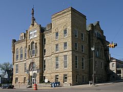
The courthouse in Ottumwa
|
|
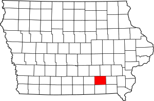
Location within the U.S. state of Iowa
|
|
 Iowa's location within the U.S. |
|
| Country | |
| State | |
| Founded | 1843 |
| Named for | Wapello |
| Seat | Ottumwa |
| Largest city | Ottumwa |
| Area | |
| • Total | 436 sq mi (1,130 km2) |
| • Land | 432 sq mi (1,120 km2) |
| • Water | 4.2 sq mi (11 km2) 1.0%% |
| Population
(2020)
|
|
| • Total | 35,437 |
| • Density | 81.28/sq mi (31.38/km2) |
| Time zone | UTC−6 (Central) |
| • Summer (DST) | UTC−5 (CDT) |
| Congressional district | 3rd |
Wapello County is a county in the state of Iowa, USA. In 2020, about 35,437 people lived here. The main city and government center is Ottumwa.
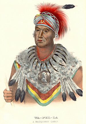
Wapello County was created on February 17, 1843. It was named after Chief Wapello, a leader of the Meskwaki people. Ottumwa, the largest city, is also the center of a "Micropolitan Statistical Area." This means it's a city and the nearby areas that are closely connected.
Contents
About the Land
Wapello County covers a total area of about 436 square miles. Most of this area, about 432 square miles, is land. The rest, about 4.2 square miles, is water.
Main Roads
You can travel through Wapello County using several important roads:
Nearby Counties
Wapello County shares borders with these other counties:
- Mahaska County to the northwest
- Keokuk County to the northeast
- Jefferson County to the east
- Davis County to the south
- Monroe County to the west
People and Population
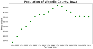
The number of people living in Wapello County has changed over the years. Here's how the population has grown and shrunk:
| Historical population | |||
|---|---|---|---|
| Census | Pop. | %± | |
| 1850 | 8,471 | — | |
| 1860 | 14,518 | 71.4% | |
| 1870 | 22,346 | 53.9% | |
| 1880 | 25,285 | 13.2% | |
| 1890 | 30,426 | 20.3% | |
| 1900 | 35,426 | 16.4% | |
| 1910 | 37,743 | 6.5% | |
| 1920 | 37,937 | 0.5% | |
| 1930 | 40,480 | 6.7% | |
| 1940 | 44,280 | 9.4% | |
| 1950 | 47,397 | 7.0% | |
| 1960 | 46,126 | −2.7% | |
| 1970 | 42,149 | −8.6% | |
| 1980 | 40,241 | −4.5% | |
| 1990 | 35,696 | −11.3% | |
| 2000 | 36,051 | 1.0% | |
| 2010 | 35,625 | −1.2% | |
| 2020 | 35,437 | −0.5% | |
| 2023 (est.) | 35,166 | −1.3% | |
| U.S. Decennial Census 1790-1960 1900-1990 1990-2000 2010-2018 |
|||
What the 2020 Census Showed
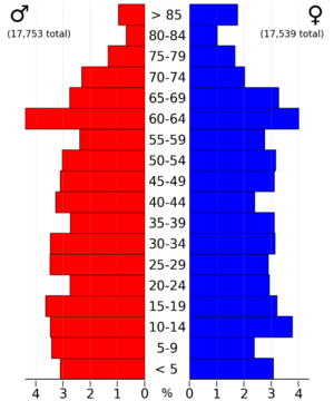
In 2020, the census counted 35,437 people in Wapello County. This means there were about 81 people living in each square mile. There were 15,734 homes, and 14,167 of them were lived in.
The census also looked at the different backgrounds of the people living in the county:
| Race | Number of People | Percentage |
|---|---|---|
| White | 27,295 | 77.02% |
| Black or African American | 1,443 | 4.1% |
| Native American | 66 | 0.2% |
| Asian | 622 | 1.8% |
| Pacific Islander | 518 | 1.5% |
| Other/Mixed | 1,161 | 3.3% |
| Hispanic or Latino | 4,332 | 12.22% |
Towns and Communities
Wapello County has several cities and smaller communities.
Cities
Smaller Communities (Unincorporated)
These places are not officially cities or towns, but people live there:
- Ashland
- Bladensburg
- Dahlonega
- Dudley
- Farson
- Munterville
- Phillips
- Pickwick
- Ottumwa Junction
- Rutledge
Townships
Counties in Iowa are divided into smaller areas called townships. Here are the townships in Wapello County:
- Adams
- Agency
- Cass
- Center
- Columbia
- Competine
- Dahlonega
- Green
- Highland
- Keokuk
- Pleasant
- Polk
- Richland
- Washington
City Populations (2020 Census)
This table shows the population of the cities in Wapello County, from largest to smallest.
† county seat (the main city for the county government)
| Rank | City/Town/etc. | Type | Population (2020 Census) |
|---|---|---|---|
| 1 | † Ottumwa | City | 25,529 |
| 2 | Eddyville (partially in Mahaska and Monroe Counties) | City | 970 |
| 3 | Eldon | City | 783 |
| 4 | Agency | City | 620 |
| 5 | Blakesburg | City | 274 |
| 6 | Kirkville | City | 157 |
| 7 | Chillicothe | City | 76 |
See also
 In Spanish: Condado de Wapello para niños
 | Dorothy Vaughan |
 | Charles Henry Turner |
 | Hildrus Poindexter |
 | Henry Cecil McBay |


