Bradgate, Iowa facts for kids
Quick facts for kids
Bradgate, Iowa
|
|
|---|---|

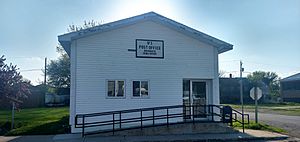
Post office
|
|
| Motto(s):
The town that wouldn’t die
|
|

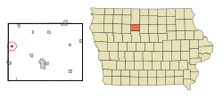
Location of Bradgate, Iowa
|
|
| Country | |
| State | |
| County | Humboldt |
| Incorporated | June 20, 1893 |
| Area | |
| • Total | 0.53 sq mi (1.37 km2) |
| • Land | 0.52 sq mi (1.35 km2) |
| • Water | 0.01 sq mi (0.01 km2) |
| Elevation | 1,125 ft (343 m) |
| Population
(2020)
|
|
| • Total | 75 |
| • Density | 143.40/sq mi (55.36/km2) |
| Time zone | UTC-6 (Central (CST)) |
| • Summer (DST) | UTC-5 (CDT) |
| ZIP code |
50520
|
| Area code(s) | 515 |
| FIPS code | 19-08065 |
| GNIS feature ID | 0454799 |
Bradgate is a small city in Humboldt County, Iowa, United States. It is located near the West Fork of the Des Moines River. In 2020, 75 people lived there. This was a decrease from 101 people in 2000.
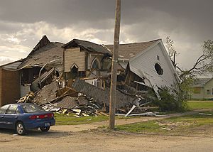
Bradgate is known for its strong spirit. On May 21, 2004, a powerful tornado almost completely destroyed the town.
Contents
History of Bradgate
Last Battle of Native American Tribes
A place called Avery's Hill, near Bradgate, was the site of an important event. The last battle between two American Indian tribes in Iowa happened here in 1854. The Sioux and the Winnebagos fought on this hill.
About eighteen Sioux warriors, led by Coustawa (Big Tree), surprised the Winnebago tribe. But the Winnebagos fought back and drove them away after Coustawa was killed. One of the Sioux warriors was Inkpaduta, who later led a famous attack called the Spirit Lake Massacre.
Today, a flag pole and a plaque mark the battle spot. People living near Bradgate have found many artifacts like arrowheads on Avery's Hill and along the river. These items show that Native Americans lived and hunted here long ago.
How Bradgate Got Its Name
The first settlement in this area was called Willow Glen. No one knows why that name was chosen. Later, when the town was officially planned, its name changed to Bradgate.
Most people believe Bradgate was named after Bradgate Park in England. This park is near a town called Newtown Linford in Leicestershire County. Just like Bradgate, Iowa, is near Rutland, Iowa, Bradgate Park in England is near Rutland County. Several English families moved directly from England to the Bradgate, Iowa, area.
Bradgate was officially planned in 1881–1882 for the Chicago and North Western Railway. The post office opened on April 7, 1882. Cord N. King, an early farmer and store owner, gave much of his land to the railroad. He hoped a train terminal would be built there. However, a big flood in 1881 caused the terminal to be moved to Eagle Grove instead.
John Wesley King built a house near the post office. He became the town's first postmaster.
“The Town That Wouldn’t Die”
In 1950, three people from Life Magazine visited Bradgate. They took many pictures and interviewed almost everyone. They wanted to write a special story about a small Iowa town.
When the magazine came out in August 1950, the people of Bradgate were excited. But they were disappointed when they read the story. It showed Bradgate as a "dying town."
This upset the residents for many years. In 1976, the town chose the motto “The town that wouldn’t die.” This motto shows their strong will to keep going and prove the magazine wrong.
The 2004 Tornado
On May 21, 2004, a strong tornado hit Bradgate. It was rated F2 on the Fujita scale. This means its winds were estimated to be between 113 and 157 miles per hour.
The tornado severely damaged 30 out of 42 homes in Bradgate. The only building that was not damaged was the new fire station. Fifteen people had minor injuries from flying debris. Luckily, no one died.
The tornado traveled about 16 miles. It damaged farmhouses, trees, and power lines along its path. Power lines and poles were knocked down, blocking roads. Despite the damage, the people of Bradgate were thankful that everyone survived.
Geography
Bradgate is located at 42.803434 degrees north latitude and -94.420405 degrees west longitude.
The city covers a total area of about 0.53 square miles (1.37 square kilometers). Almost all of this area is land.
Population Information
| Historical population | |||
|---|---|---|---|
| Census | Pop. | %± | |
| 1900 | 223 | — | |
| 1910 | 175 | −21.5% | |
| 1920 | 230 | 31.4% | |
| 1930 | 223 | −3.0% | |
| 1940 | 261 | 17.0% | |
| 1950 | 188 | −28.0% | |
| 1960 | 166 | −11.7% | |
| 1970 | 130 | −21.7% | |
| 1980 | 151 | 16.2% | |
| 1990 | 124 | −17.9% | |
| 2000 | 101 | −18.5% | |
| 2010 | 86 | −14.9% | |
| 2020 | 75 | −12.8% | |
| U.S. Decennial Census | |||
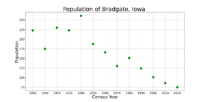
The population of Bradgate has changed over the years. In 1900, there were 223 people. By 2020, the population was 75.
2020 Census Details
In 2020, there were 75 people living in Bradgate. These people lived in 33 households. About 24% of households had children under 18. The average age in the city was 45.5 years. About 32% of residents were under 20 years old.
2010 Census Details
In 2010, Bradgate had 86 people living there. There were 37 households. The average age was 44.3 years. About 22% of residents were under 18.
Parks and Recreation
Avery's Hill
Avery's Hill is a popular local spot west of town. It is named after Oscar F. Avery, the first settler in the area. People visit the hill to enjoy nature, see wildlife, and hunt for mushrooms.
Avery's Hill is also a wildlife refuge. For many years, local kids have enjoyed sledding and tobogganing down its large slopes. In the 1970s, people worked to protect this scenic area from being farmed.
This hill was also the site of the last battle between two American Indian tribes in Iowa, which happened in 1854.
Bradgate State Fishing Access
The Bradgate State Fishing Access is one of Iowa's many state parks and wildlife refuges. It is a fishing area along the West Fork of the Des Moines River, right on Bradgate's southern edge.
Three Rivers Bike Trail
The Three Rivers Bike Trail is a fun bike path that goes through Bradgate. It was built on an old railroad track and finished in 1991. A cool part of the trail is where it crosses the West Fork of the Des Moines River on the west side of town.
The trail is 35 miles long. It stretches from Rolfe to Eagle Grove. You can get on the trail in Bradgate, Rutland, Dakota City, and Thor. The trail offers different views, from forests near the river to open farmlands.
Education
Children from Bradgate attend schools in the Gilmore City–Bradgate Community School District.
Twin Town
Bradgate is a twin town with Newtown Linford in Leicestershire, England. This is the town near Bradgate Park, which Bradgate, Iowa, was named after.
See also
 In Spanish: Bradgate (Iowa) para niños
 | Delilah Pierce |
 | Gordon Parks |
 | Augusta Savage |
 | Charles Ethan Porter |


