
Lester River facts for kids
Quick facts for kids Lester River |
|
|---|---|
| Native name | Basaabikaa-ziibi |
| Physical characteristics | |
| River mouth | Lake Superior |
| Length | 19.3 mi (31.1 km) |
| Basin features | |
| Basin size | 58 sq mi (150 sq km) |
The Lester River is a cool river in northeastern Minnesota, United States. It's about 19.3-mile-long (31.1 km) and flows into the big Lake Superior. This river helps drain an area of about 58 square miles (150 km2).
Contents
Where Does the Lester River Flow?
The Lester River flows entirely within southern Saint Louis County. It starts in Gnesen Township. From there, it generally flows southeast through the city of Rice Lake. It also passes through Lakewood Township.
As it gets closer to Lake Superior, the river turns southward. It finally flows into the lake in the eastern part of Duluth.
What's in a Name?
The Lester River has a special name in the Ojibwe language. It is called Basaabikaa-ziibi. This means "Rocky Canyon River." This name makes sense because the river flows through a canyon. This canyon is located between Lester Park and the river's mouth. Amity Creek also joins the Lester River in this area.
History of the Lester River
The Lester River is named after one of the first people to settle in the area.
Important Old Buildings
There are two important places along the Lester River. These places are listed on the National Register of Historic Places. This means they are special and worth protecting.
- Lester River Bridge (Bridge No. 5772): This is a historic bridge that crosses the river.
- US Fisheries Station, Duluth: This building was built in 1882. It is located right where the Lester River meets Lake Superior. The University of Minnesota Duluth now owns it. For a while, it even held the offices for the Great Lakes Aquarium.
What is the Fisheries Station?
The Fisheries Station is a group of buildings. It includes a Hatchery/Bunk-room Building, a Boat House, and a Pump House. There's also a Supervisor's Cabin and a Superintendent's House. These buildings were used to help fish, like a fish farm. Between 2011 and 2013, the station was fully updated and repaired.
Gallery
-
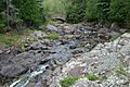
A stream flowing into the Lester River in Duluth
-
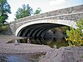
Lester River Bridge near Lake Superior
-
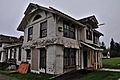
U.S. Fisheries station during renovation in 2012
-
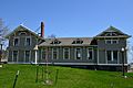
U.S. Fisheries station after renovation


.jpg)
.jpg)
