Milford, Iowa facts for kids
Quick facts for kids
Milford, Iowa
|
|
|---|---|

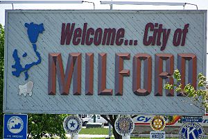
Welcome sign on U.S. Highway 71
|
|

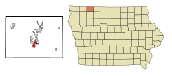
Location of Milford, Iowa
|
|
| Country | United States |
| State | Iowa |
| County | Dickinson |
| Area | |
| • Total | 2.19 sq mi (5.66 km2) |
| • Land | 2.18 sq mi (5.64 km2) |
| • Water | 0.01 sq mi (0.03 km2) |
| Elevation | 1,440 ft (439 m) |
| Population
(2020)
|
|
| • Total | 3,321 |
| • Density | 1,525.49/sq mi (588.93/km2) |
| Time zone | UTC-6 (Central (CST)) |
| • Summer (DST) | UTC-5 (CDT) |
| ZIP code |
51351
|
| Area code(s) | 712 |
| FIPS code | 19-52095 |
| GNIS feature ID | 0459076 |
| Website | https://milford.ia.us/ |
Milford is a city in Dickinson County, Iowa, in the United States. In 2020, about 3,321 people lived there. Milford is known for being close to the Iowa Great Lakes. It is often called the "southern gateway" to this popular lake area. Many businesses in Milford serve visitors to the lakes.
Contents
History of Milford
The Iowa Great Lakes area was first settled in the 1850s. Many early settlers came here because of the rich soil. They also liked the water from the lakes and the many wild animals and fish. As more people moved in, they needed a place to grind grain into flour. The closest mills were far away in Mankato, Minnesota, and Fort Dodge, Iowa.
In 1861, people tried to build a flour mill on Mill Creek. This creek flows out of the Great Lakes. But the plan was stopped because of the Dakota-U.S. War of 1862. Also, the water level was very low that year. In 1868, a mill was successfully built. A sawmill started working in 1869. These mills brought many customers, and a small community grew around them. This area was called Old Town. In 1870, the mill company bought land northwest of Old Town. They planned out the new town of Milford there.
The first Town Council meeting was held on March 14, 1892. Some buildings were moved from Old Town to the new area. Many more businesses and homes were built. In 1921, the U.S. flag was flown at the new city hall for the first time. That same year, people voted to pave Okoboji Avenue, which is Milford's main street.
The Milwaukee rail line ran through Milford. It brought mail, groceries, clothes, lumber, coal, and machinery to the town. This was before cars could easily reach the Great Lakes. Two passenger trains traveled daily from Des Moines to Spirit Lake. Another train went from Spencer. Until 1910, special trains brought visitors to the Lakes Area on weekends and holidays. The last passenger train left Milford for Spencer in 1951. The last freight train left Milford in 1976. The train tracks were removed in 1978. Later, they became part of the Iowa Great Lakes Recreational Trail.
Geography of Milford
Milford is located at 43°19′37″N 95°9′3″W / 43.32694°N 95.15083°W. This means it is in the northern part of the United States.
The city covers a total area of about 2.29 square miles (5.93 square kilometers). Most of this area, about 2.28 square miles (5.91 square kilometers), is land. Only a small part, about 0.01 square miles (0.03 square kilometers), is water.
Climate in Milford
Milford has a climate with warm summers and cold winters.
| Climate data for Milford, Iowa (1991−2020 normals, extremes 1919−2022) | |||||||||||||
|---|---|---|---|---|---|---|---|---|---|---|---|---|---|
| Month | Jan | Feb | Mar | Apr | May | Jun | Jul | Aug | Sep | Oct | Nov | Dec | Year |
| Record high °F (°C) | 63 (17) |
65 (18) |
85 (29) |
93 (34) |
98 (37) |
102 (39) |
103 (39) |
102 (39) |
100 (38) |
92 (33) |
78 (26) |
67 (19) |
103 (39) |
| Mean maximum °F (°C) | 43.5 (6.4) |
48.1 (8.9) |
67.1 (19.5) |
80.7 (27.1) |
88.4 (31.3) |
91.5 (33.1) |
92.5 (33.6) |
90.7 (32.6) |
87.9 (31.1) |
80.6 (27.0) |
64.2 (17.9) |
47.5 (8.6) |
94.7 (34.8) |
| Mean daily maximum °F (°C) | 24.4 (−4.2) |
28.9 (−1.7) |
41.9 (5.5) |
57.2 (14.0) |
69.5 (20.8) |
79.0 (26.1) |
82.6 (28.1) |
80.0 (26.7) |
73.9 (23.3) |
60.0 (15.6) |
43.1 (6.2) |
29.0 (−1.7) |
55.8 (13.2) |
| Daily mean °F (°C) | 15.9 (−8.9) |
20.3 (−6.5) |
32.7 (0.4) |
46.2 (7.9) |
58.6 (14.8) |
68.8 (20.4) |
72.5 (22.5) |
70.0 (21.1) |
62.8 (17.1) |
49.3 (9.6) |
33.8 (1.0) |
21.1 (−6.1) |
46.0 (7.8) |
| Mean daily minimum °F (°C) | 7.5 (−13.6) |
11.6 (−11.3) |
23.6 (−4.7) |
35.2 (1.8) |
47.7 (8.7) |
58.5 (14.7) |
62.4 (16.9) |
60.0 (15.6) |
51.8 (11.0) |
38.5 (3.6) |
24.5 (−4.2) |
13.2 (−10.4) |
36.2 (2.3) |
| Mean minimum °F (°C) | −16.4 (−26.9) |
−10.6 (−23.7) |
−0.8 (−18.2) |
18.4 (−7.6) |
31.9 (−0.1) |
46.2 (7.9) |
50.3 (10.2) |
47.8 (8.8) |
34.8 (1.6) |
20.6 (−6.3) |
4.3 (−15.4) |
−10.1 (−23.4) |
−19.6 (−28.7) |
| Record low °F (°C) | −34 (−37) |
−28 (−33) |
−22 (−30) |
2 (−17) |
18 (−8) |
34 (1) |
40 (4) |
35 (2) |
24 (−4) |
−10 (−23) |
−14 (−26) |
−29 (−34) |
−34 (−37) |
| Average precipitation inches (mm) | 0.70 (18) |
0.74 (19) |
1.61 (41) |
3.25 (83) |
4.21 (107) |
4.47 (114) |
3.40 (86) |
3.47 (88) |
3.21 (82) |
2.22 (56) |
1.38 (35) |
0.84 (21) |
29.50 (749) |
| Average snowfall inches (cm) | 8.7 (22) |
9.3 (24) |
5.3 (13) |
2.5 (6.4) |
0.1 (0.25) |
0.0 (0.0) |
0.0 (0.0) |
0.0 (0.0) |
0.0 (0.0) |
0.5 (1.3) |
3.0 (7.6) |
8.6 (22) |
38.0 (97) |
| Average precipitation days (≥ 0.01 in) | 6.8 | 6.6 | 6.2 | 8.2 | 10.5 | 9.2 | 8.2 | 7.6 | 7.1 | 6.2 | 5.6 | 6.0 | 88.2 |
| Average snowy days (≥ 0.1 in) | 4.7 | 4.6 | 1.8 | 0.7 | 0.0 | 0.0 | 0.0 | 0.0 | 0.0 | 0.3 | 2.1 | 3.9 | 18.1 |
| Source: NOAA | |||||||||||||
Milford's Population
| Historical populations | ||
|---|---|---|
| Year | Pop. | ±% |
| 1880 | 235 | — |
| 1900 | 485 | +106.4% |
| 1910 | 575 | +18.6% |
| 1920 | 908 | +57.9% |
| 1930 | 1,062 | +17.0% |
| 1940 | 1,202 | +13.2% |
| 1950 | 1,375 | +14.4% |
| 1960 | 1,476 | +7.3% |
| 1970 | 1,668 | +13.0% |
| 1980 | 2,076 | +24.5% |
| 1990 | 2,170 | +4.5% |
| 2000 | 2,474 | +14.0% |
| 2010 | 2,898 | +17.1% |
| 2020 | 3,321 | +14.6% |
| Source: and Iowa Data Center Source: |
||
Milford's population has grown steadily over the years. In 1880, only 235 people lived there. By 2020, the population had grown to 3,321 people.
Milford in 2020
In 2020, the census showed 3,321 people living in Milford. There were 1,416 households. About 92.5% of the people were White. About 3.7% of the population were Hispanic or Latino.
About 29.5% of households had children under 18. The average age in the city was 41.0 years. About 26.7% of residents were under 20 years old. About 20.9% were 65 years or older. The population was almost evenly split between males (49.5%) and females (50.5%).
Parks and Fun Activities
Milford has several parks for everyone to enjoy.
- Florence Park is near the high school. It has picnic areas and a large playground. There is also a shelter house you can rent.
- Memorial Park has three baseball fields and two tennis courts. It also has a basketball court, a horseshoe pitch, and a volleyball court. You'll find a playground, two shelters, and a picnic area there too.
- Buchanan Park offers a playground, a shelter, a basketball court, and a chess table.
Recreational Trails for Fun
The Iowa Great Lakes Trails are a group of paths for fun activities. They cover almost 30 miles in the Iowa Great Lakes area. People can walk, bike, skate, rollerblade, run, or cross-country ski on them. One part of the main 14-mile trail starts in Milford. It goes through Arnolds Park and Okoboji to Spirit Lake. Another trail starts northwest of Milford. It follows Highway 86 along the west side of West Okoboji Lake.
Horseshoe Bend Recreational Area
Horseshoe Bend Recreational Area is a large park about five miles southwest of Milford. It covers 180 acres (0.73 square kilometers). The park has picnic areas and a shelter house with restrooms that can be rented. There are 12 simple campsites. You can also find over four miles of mowed trails for hiking, horseback riding, snowmobiling, and cross-country skiing. The park also has a place to launch canoes and fish in the Little Sioux River. In winter, there's a special area for skiing and tubing. It has lifts and a lodge with restrooms.
The Iowa Great Lakes
Milford is at the south end of the Iowa Great Lakes. This is a very popular area, especially in summer. The number of people in Dickinson County can grow to about 100,000 visitors and residents. People love to fish, boat, and swim in the seven lakes that make up the Iowa Great Lakes chain.
Businesses in Milford
Milford has some interesting businesses that are important to the area.
Milford's "Hidden Gold"
Since 1910, businesses have used the large amounts of gravel found in and around Milford. The Milwaukee Railroad first started mining it. To the east, west, and south of town, there are gravel pits. Some are no longer used and have become junkyards. Others are still active and change the land quickly. Milford Sand & Gravel is one company that digs up and washes the gravel for different uses.
Milford Grain Elevator
The Milford Elevator is very important for farmers in the Milford area. It helps them store and sell their grain. It used to be owned by Great Lakes Cooperative. On April 3, 2008, it joined with Green Plains Renewable Energy. Now, The Andersons company owns and runs the grain elevator.
Education in Milford
Milford is part of the Okoboji Community School District. This school district was created on July 1, 1988. It was formed when the Arnolds Park and Milford school districts joined together.
The district has three schools in Milford:
- Okoboji Community High School
- Okoboji Community Middle School
- Okoboji Community Elementary School
All these schools are part of the Okoboji Community School District. The school mascot is the Okoboji Pioneer. The school colors are maroon and white.
Milford also has a library called the Milford Memorial Library.
Notable People from Milford
- John L. Bascom, a lawyer and Iowa State Representative.
- Paul Nesbitt, a doctor and Oklahoma State Legislator.
See also
 In Spanish: Milford (Iowa) para niños
 | Tommie Smith |
 | Simone Manuel |
 | Shani Davis |
 | Simone Biles |
 | Alice Coachman |


