
Fonda, Iowa facts for kids
Quick facts for kids
Fonda, Iowa
|
|
|---|---|

Location of Fonda, Iowa
|
|
| Country | |
| State | |
| County | Pocahontas |
| Area | |
| • Total | 1.00 sq mi (2.60 km2) |
| • Land | 1.00 sq mi (2.60 km2) |
| • Water | 0.00 sq mi (0.00 km2) |
| Elevation | 1,220 ft (372 m) |
| Population
(2024)
|
|
| • Total | 632 |
| • Density | 633.47/sq mi (244.70/km2) |
| Time zone | UTC-6 (Central (CST)) |
| • Summer (DST) | UTC-5 (CDT) |
| ZIP code |
50540
|
| Area code(s) | 712 |
| FIPS code | 19-28245 |
| GNIS feature ID | 0456657 |
Fonda is a small city located in Pocahontas County, Iowa, in the United States. In 2024, about 632 people were estimated to live there.
Contents
History of Fonda
The city of Fonda was first known as Marvin. However, this name sounded too much like Manson, Iowa. Because mail often got mixed up, city leaders decided to change the name. In 1874, the city was renamed Fonda. The closest city with the same name is Fonda, New York.
Geography and Landscape
Fonda is located at 42°34′58″N 94°50′45″W / 42.58278°N 94.84583°W. This means it is in the western part of Iowa. The city covers about 1.05 square miles (2.72 square kilometers) of land. There is no water within the city limits.
Land Features Around Fonda
Fonda is on the western edge of the Des Moines Lobe. This area was shaped by glaciers a long time ago. It is known for its gently rolling hills and many wetlands. These wetlands are often called prairie potholes. The land around Fonda also has large flat areas and some ridges.
In its natural state, the land here did not drain water well. To help with farming, people added many underground pipes called tiles. These tiles move water from the wetlands into local streams. The tiles around Fonda drain into Big Cedar Creek. This creek flows past the west side of town. It is a branch of the Raccoon River.
Wildlife and Natural Areas
About four miles (6 kilometers) northwest of Fonda is the Sunken Grove Wildlife Management Area (WMA). This area has large wetlands that are not drained. It also has forests and prairies. Many birds that migrate (travel seasonally) visit this area. It is also home to many animals that live there all year.
The Sunken Grove WMA has recently grown larger. It is next to the Leo Shimon WMA. Together, these two areas cover about 1,148 acres (4.65 square kilometers). This is a great place to see nature and wildlife.
Farming and Agriculture
Most of the land around Fonda is used for farming. You will see large fields of corn and soybeans. There are also smaller farms and places where hogs are raised. These are sometimes called hog confinements.
Farming in the area has changed over time. There are now fewer farms, but they are much larger. Farmers use more chemicals and different ways of tilling the soil. This has changed the economy of Fonda and the surrounding countryside. For example, Fonda's AgPartners elevator is partly owned by a big company called Cargill. Many hog farms are owned by large corporations.
The number of farms in Pocahontas County has gone down a lot. In 1969, there were 1,369 farms. By 1997, this number dropped to 778. The average farm size grew from 265 acres to 459 acres during that time. In 1969, 844 farms sold 176,705 hogs. By 1997, only 162 farms sold 248,666 hogs. This shows how farming has become more focused on larger operations.
Water Quality Concerns
The city of Des Moines is about 135 miles (217 kilometers) southeast of Fonda. A lot of its drinking water comes from the Raccoon River. This river gets water from Big Cedar Creek, which flows near Fonda.
From 1978 to 2004, the amount of nitrates in the water increased. Nitrates are chemicals often found in fertilizers used in farming. High levels of nitrates in drinking water can be a health concern, especially for babies.
Population and People
| Historical population | ||
|---|---|---|
| Year | Pop. | ±% |
| 1880 | 1,684 | — |
| 1890 | 625 | −62.9% |
| 1900 | 1,180 | +88.8% |
| 1910 | 978 | −17.1% |
| 1920 | 1,136 | +16.2% |
| 1930 | 1,027 | −9.6% |
| 1940 | 1,188 | +15.7% |
| 1950 | 1,120 | −5.7% |
| 1960 | 1,026 | −8.4% |
| 1970 | 980 | −4.5% |
| 1980 | 863 | −11.9% |
| 1990 | 731 | −15.3% |
| 2000 | 648 | −11.4% |
| 2010 | 631 | −2.6% |
| 2020 | 636 | +0.8% |
| 2024 | 632 | −0.6% |
| Source: and Iowa Data Center Source: |
||

Fonda's population has slowly decreased over the past few decades. In 1980, there were 863 people living in the city. By 2020, the population was 636.
2020 Census Information
According to the census in 2020, there were 636 people living in Fonda. These people lived in 248 households. A household is a group of people living together in one home. There were 154 families.
The population density was about 634 people per square mile (245 people per square kilometer). Most people living in Fonda (76.7%) were White. About 19.5% of the population was Hispanic or Latino.
The average age of people in Fonda was 38.5 years old. About 27.5% of the residents were under 20 years old. About 20.6% were 65 years old or older. The population was almost evenly split between males (50.9%) and females (49.1%).
Education in Fonda
Fonda is part of the Newell-Fonda Community School District. This school district operates Newell-Fonda High School in Newell. Before 1993, Fonda had its own school district. On July 1, 1993, it joined with Newell to form the current district.
Notable People from Fonda
Many interesting people have connections to Fonda, Iowa. Here are a few:
- Henry A. Kelly (born 1934), a well-known English professor at UCLA.
- Jim Kelly (1893-1972), a basketball coach for DePaul University. He also coached track-and-field for the University of Minnesota and the 1956 U.S. Olympic team.
- Ruth Stafford Peale (1906–2008), a writer who helped start Guideposts magazine with her husband.
- Nathan Post (1881–1938), who served as the 8th and 10th Governor of American Samoa.
Images for kids
-
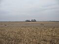
Typical landscape around Fonda, 3 miles (5 km) south of town. Notice the ridges on both sides of a drained wetland.
-
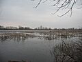
Muskrat houses and cattails in Sunken Island Lake, part of Sunken Grove WMA, 4 miles (6 km) northwest of Fonda.
-
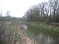
Big Cedar Creek, flowing behind Our Lady of Good Counsel Catholic Church on the west side of town.
-
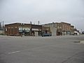
East side of Main Street in Fonda, showing local businesses, the senior citizen's center, and the Fonda Museum.
-
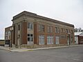
The old First National Bank building, which now holds two businesses.
-
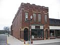
The old hardware store, now partly restored and home to an antique shop.
-
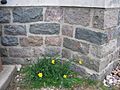
The foundation of Our Lady of Good Counsel Catholic Church, built from local stones in the early 1900s.


See also
 In Spanish: Fonda (Iowa) para niños
