
McGregor, Iowa facts for kids
Quick facts for kids
McGregor, Iowa
|
|
|---|---|

|
|

Location of McGregor, Iowa
|
|
| Country | |
| State | |
| County | Clayton |
| Area | |
| • Total | 1.30 sq mi (3.36 km2) |
| • Land | 1.29 sq mi (3.35 km2) |
| • Water | 0.00 sq mi (0.00 km2) |
| Elevation | 692 ft (211 m) |
| Population
(2020)
|
|
| • Total | 742 |
| • Density | 573.42/sq mi (221.41/km2) |
| Time zone | UTC-6 (Central (CST)) |
| • Summer (DST) | UTC-5 (CDT) |
| ZIP code |
52157
|
| Area code(s) | 563 |
| FIPS code | 19-48000 |
| GNIS feature ID | 0458913 |
McGregor is a city in Clayton County, Iowa, United States. It is located right on the Mississippi River. Across the river is Prairie du Chien, Wisconsin. In 2020, about 742 people lived there.
Pike's Peak State Park is just south of McGregor. The city of Marquette is to the north. A smaller community called McGregor Heights is in the southern part of the city.
Contents
History of McGregor
McGregor was started in 1847 by Alexandar MacGregor. He was a descendant of Rob Roy MacGregor. The area was first called MacGregor's Landing. His family helped settle the land around it.
Since 1837, MacGregor ran a ferry boat service. This ferry carried people and goods across the Mississippi River. It connected Prairie du Chien, Wisconsin, with the future site of McGregor, Iowa.
The new city was planned with six blocks. It grew quickly and became an official city in 1857. In the same year, a railroad line was finished. This line connected Milwaukee, Wisconsin to Prairie du Chien. This linked Lake Michigan to the Mississippi River by train.
McGregor soon became a big trading center. It was a place where grain from Iowa and Minnesota was brought. The grain was then sent across the Mississippi River by ferry. From there, it traveled by train to Milwaukee. For example, around 1860, Joseph "Diamond Jo" Reynolds moved to McGregor. He started a grain trading business. He later owned his own steamboats. His old office building, the Diamond Jo office building, is still in the city today.
More railroads were built to connect McGregor with towns further west. The city of North McGregor (now Marquette, Iowa) was built just north of McGregor. It served as the main train station. When trains arrived from the west, they were taken apart. The train cars were then ferried across the Mississippi River. They would then continue their journey towards Lake Michigan.
Early residents of McGregor used the soft sandstone bedrock. They carved cellars into it for cold storage. These were also used for aging beer. Many of these old entryways can still be seen today.
In 1874, a new pontoon bridge was built. This bridge connected the train lines between North McGregor and Prairie du Chien. It meant trains no longer needed to be ferried across the river. Because of this, the city's population started to get smaller. Fewer people were needed to move the trains.
The city's past is kept alive in the McGregor Commercial Historic District. This area has many buildings from the city's busiest years. McGregor is now a popular place for tourists in the summer. People enjoy its history and its location by the Mississippi River. It is also known for its many antique stores.
A big storm hit the city on July 19, 2017. The downtown area was especially affected.
Geography
McGregor is located at 43°1′19″N 91°10′47″W / 43.02194°N 91.17972°W. The city sits at the bottom of tall, steep sandstone cliffs. These cliffs are made of St. Peter Sandstone and Jordan Formation. The city covers an area of about 1.30 square miles (3.36 square kilometers). All of this area is land.

Population Data
| Historical populations | ||
|---|---|---|
| Year | Pop. | ±% |
| 1860 | 1,989 | — |
| 1870 | 2,074 | +4.3% |
| 1880 | 1,602 | −22.8% |
| 1890 | 1,160 | −27.6% |
| 1900 | 1,498 | +29.1% |
| 1910 | 1,259 | −16.0% |
| 1920 | 1,289 | +2.4% |
| 1930 | 1,299 | +0.8% |
| 1940 | 1,309 | +0.8% |
| 1950 | 1,138 | −13.1% |
| 1960 | 1,040 | −8.6% |
| 1970 | 990 | −4.8% |
| 1980 | 945 | −4.5% |
| 1990 | 797 | −15.7% |
| 2000 | 871 | +9.3% |
| 2010 | 871 | +0.0% |
| 2020 | 742 | −14.8% |
| Source: and Iowa Data Center Source: |
||
2020 Census Information
In 2020, the city had 742 people living there. There were 366 households. The population density was about 573 people per square mile. Most residents were White (95.3%). About 1.5% of the population was Hispanic or Latino.
The average age in McGregor was 53.2 years. About 15.5% of the residents were under 20 years old. About 31.9% were 65 years or older. The population was almost evenly split between males (49.9%) and females (50.1%).
2010 Census Information
In 2010, McGregor had 871 people. There were 410 households. The population density was about 670 people per square mile. Most people were White (96.9%). About 1.7% of the population was Hispanic or Latino.
The average age in the city was 48.3 years. About 17.8% of residents were under 18. About 23.8% were 65 years or older.
Education
McGregor is part of the MFL MarMac Community School District. This school district was formed in 1994. It was created when the Mar-Mac and M-F-L districts joined together.
Notable People
Many interesting people have connections to McGregor:
- Samuel Merrill, who was the Governor of Iowa from 1868 to 1872.
- Leo Stanton Rowe, who led the Pan-American Union from 1920 to 1946.
- The Ringling brothers, famous for their circus.
- John Ward Studebaker, who was the U.S. Commissioner of Education.
- Thomas Updegraff, who served in the United States House of Representatives from Iowa.
- Andrew Clemens, a talented sand artist.
- Dorothy M. Johnson, an author.
- Joseph "Diamond Joe" Reynolds, a steamboat owner and grain dealer.
- Lucy Hobbs Taylor, the first woman in the world to become a Doctor of Dental Surgery.
- Lucy Maynard Salmon, an American historian and professor at Vassar College.
- Marian E. Hubbard, a zoologist and professor at Wellesley College.
- Frank Lloyd Wright, a very famous American architect, lived here as a baby from 1867-1869.
Images for kids
-
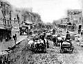
McGregor in 1870

See also
 In Spanish: McGregor (Iowa) para niños
