
Marquette, Iowa facts for kids
Quick facts for kids
Marquette, Iowa
|
|
|---|---|

US-18 is carried by Marquette–Joliet Bridge into Marquette, Iowa
|
|

Location of Marquette, Iowa
|
|
| Country | |
| State | |
| County | Clayton |
| Area | |
| • Total | 1.92 sq mi (4.98 km2) |
| • Land | 1.86 sq mi (4.81 km2) |
| • Water | 0.07 sq mi (0.17 km2) |
| Elevation | 627 ft (191 m) |
| Population
(2020)
|
|
| • Total | 429 |
| • Density | 231.14/sq mi (89.24/km2) |
| Time zone | UTC-6 (Central (CST)) |
| • Summer (DST) | UTC-5 (CDT) |
| ZIP code |
52158
|
| Area code(s) | 563 |
| FIPS code | 19-49620 |
| GNIS feature ID | 0458816 |
Marquette is a small city in Clayton County, Iowa, United States. It sits right on the Mississippi River. In 2020, about 429 people lived there. The city is named after Jacques Marquette, a Jesuit missionary. He and Louis Joliet found the Mississippi River near here in 1673.
Contents
History of Marquette
Marquette is located directly across the river from Prairie du Chien, Wisconsin. These two cities are connected by U.S. Route 18. This road crosses the river on the Marquette-Joliet Bridge.
Early Days as North McGregor
Marquette was first called North McGregor. It became an official city in 1874. It was a very important spot for the railroad. Trains brought grain from Iowa and Minnesota through the city. This grain was then sent to Lake Michigan.
The Railroad and Pontoon Bridge
At first, trains had to be carried across the river on ferries. This changed when a businessman named John Lawler built a special pontoon bridge. This bridge connected the train lines in Marquette and Prairie du Chien.
Marquette then became a major rail yard. In 1920, it was the busiest rail yard in Iowa. About 400 people worked there. However, the importance of railroads began to decline. The last passenger train left Marquette in 1960. The pontoon bridge was taken apart in 1961.
Marquette Today
Today, Marquette is a popular place for tourists. People visit to enjoy the mighty Mississippi River. Nearby attractions include Effigy Mounds National Monument and the Yellow River State Forest. The city of McGregor is also very close by.
Geography of Marquette
Marquette covers a total area of about 1.92 square miles (4.98 square kilometers). Most of this area, about 1.86 square miles (4.81 square kilometers), is land. The rest, about 0.07 square miles (0.17 square kilometers), is water.
Population and Demographics
| Historical populations | ||
|---|---|---|
| Year | Pop. | ±% |
| 1880 | 519 | — |
| 1890 | 509 | −1.9% |
| 1900 | 616 | +21.0% |
| 1910 | 588 | −4.5% |
| 1920 | 923 | +57.0% |
| 1930 | 814 | −11.8% |
| 1940 | 747 | −8.2% |
| 1950 | 641 | −14.2% |
| 1960 | 572 | −10.8% |
| 1970 | 509 | −11.0% |
| 1980 | 528 | +3.7% |
| 1990 | 479 | −9.3% |
| 2000 | 421 | −12.1% |
| 2010 | 375 | −10.9% |
| 2020 | 429 | +14.4% |
| Source: and Iowa Data Center Source: |
||
2020 Census Information
In 2020, the city of Marquette had 429 people living there. There were 208 households in total. The population density was about 231 people per square mile. Most residents, about 95.1%, identified as White.
The median age in Marquette was 45.6 years. About 20.3% of the people were under 20 years old. About 21.4% were 65 years old or older. The population was almost evenly split between males (51.7%) and females (48.3%).
2010 Census Information
According to the 2010 census, 375 people lived in Marquette. There were 182 households. The population density was about 215 people per square mile. Most people, about 98.7%, were White.
The median age was 46.6 years. About 19.2% of residents were under 18 years old. About 20.8% were 65 years or older. The gender split was very close, with 49.9% male and 50.1% female.
Education in Marquette
Students in Marquette attend schools within the MFL MarMac Community School District. This school district was created on July 1, 1994. It formed when the Mar-Mac and M-F-L districts joined together.
Images for kids
-
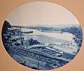
Pontoon bridge near Marquette, 1885

See also
 In Spanish: Marquette (Iowa) para niños
