
Buchanan County, Iowa facts for kids
Quick facts for kids
Buchanan County
|
|
|---|---|

|
|

Location within the U.S. state of Iowa
|
|
 Iowa's location within the U.S. |
|
| Country | |
| State | |
| Founded | 1837 |
| Named for | James Buchanan |
| Seat | Independence |
| Largest city | Independence |
| Area | |
| • Total | 573 sq mi (1,480 km2) |
| • Land | 571 sq mi (1,480 km2) |
| • Water | 2.1 sq mi (5 km2) 0.4% |
| Population
(2020)
|
|
| • Total | 20,565 |
| • Estimate
(2023)
|
20,691 |
| • Density | 35.89/sq mi (13.857/km2) |
| Time zone | UTC−6 (Central) |
| • Summer (DST) | UTC−5 (CDT) |
| Congressional district | 1st |

Buchanan County is a cool place in the state of Iowa, USA. It's like a big neighborhood with its own government. In 2020, about 20,565 people lived here. The main town, or county seat, is Independence. The county was started way back in 1837. It was named after James Buchanan, who later became the 15th President of the United States.
Contents
History of Buchanan County
Buchanan County was officially created on December 21, 1837. It was formed from parts of another area called Dubuque County. The county got its name from James Buchanan. He was a US Senator who later became the President of the United States.
Geography and Roads
Buchanan County covers about 573 square miles. Most of this area is land, with only a small part being water.
Main Roads You Might See
If you travel through Buchanan County, you'll see some important roads:
 Interstate 380
 U.S. Highway 20
 Iowa Highway 27
 Iowa Highway 150
 Iowa Highway 187
 Iowa Highway 281
Neighboring Counties
Buchanan County shares its borders with several other counties:
- Clayton County (to the northeast)
- Fayette County (to the north)
- Delaware County (to the east)
- Linn County (to the southeast)
- Benton County (to the southwest)
- Black Hawk County (to the west)
- Bremer County (to the northwest)
People of Buchanan County

The number of people living in Buchanan County has changed over time. Here's a quick look:
- In 1850, only 517 people lived here.
- By 1900, the population grew to over 21,000.
- In 2020, the county had 20,565 residents.
What the 2020 Census Showed
The 2020 census counted 20,565 people in Buchanan County. Most people, about 94%, identified as non-Hispanic White. Other groups included Black, Hispanic, Native American, and Asian residents. About 3.4% of the population reported being of more than one race.
Towns and Communities
Buchanan County has several towns and smaller communities.
Cities in the County
Smaller Unincorporated Communities
These are smaller places that don't have their own city government:
- Bryantsburg
- Doris
- Gatesville
- Littleton
- Monti
- Otterville
- Shady Grove

Some towns that used to be on maps of Buchanan County are now gone. For example, Hamerville and Vista were once small communities. Kier was another old town, and today the area is home to an Amish community. Many of these old towns, like Newtonville and Castleville, have few or no buildings left.
County Divisions: Townships
Buchanan County is divided into sixteen smaller areas called townships. These help organize the county:
- Buffalo
- Byron
- Cono
- Fairbank
- Fremont
- Hazleton
- Homer
- Jefferson
- Liberty
- Madison
- Middlefield
- Newton
- Perry
- Sumner
- Washington
- Westburg
Biggest Towns by Population
Here are the cities and towns in Buchanan County, ranked by how many people lived there in 2020:
| Rank | City/Town | Type | Population (2020 Census) |
|---|---|---|---|
| 1 | † Independence | City | 6,064 |
| 2 | Jesup | City | 2,508 |
| 3 | Fairbank | City | 1,111 |
| 4 | Winthrop | City | 823 |
| 5 | Hazleton | City | 713 |
| 6 | Quasqueton | City | 570 |
| 7 | Lamont | City | 429 |
| 8 | Brandon | City | 341 |
| 9 | Rowley | City | 270 |
| 10 | Aurora | City | 169 |
| 11 | Stanley | City | 81 |
† Independence is the county seat.
Education in Buchanan County
Kids in Buchanan County go to schools in different school districts. Here are some of them:
- East Buchanan Community School District
- Independence Community School District
- Jesup Community School District
- North Linn Community School District
- Oelwein Community School District
- Starmont Community School District
- Union Community School District
- Vinton-Shellsburg Community School District
- Wapsie Valley Community School District
- West Delaware County Community School District
Amish Community
Buchanan County is home to a group of Amish people. This community, called the Hazleton Old Order Amish settlement, started in 1914. By 1987, there were about 1,200 Amish people living here. The Buchanan Amish affiliation is named after this county.
Images for kids
-
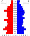
This chart shows the age groups of people in Buchanan County in 2022.

See also
 In Spanish: Condado de Buchanan (Iowa) para niños
