Stanley, Iowa facts for kids
Quick facts for kids
Stanley, Iowa
|
|
|---|---|

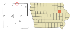
Location of Stanley, Iowa
|
|
| Country | |
| State | |
| Counties | Buchanan, Fayette |
| Incorporated | March 23, 1914 |
| Area | |
| • Total | 0.20 sq mi (0.53 km2) |
| • Land | 0.20 sq mi (0.53 km2) |
| • Water | 0.00 sq mi (0.00 km2) |
| Elevation | 1,115 ft (340 m) |
| Population
(2020)
|
|
| • Total | 81 |
| • Density | 399.01/sq mi (153.97/km2) |
| Time zone | UTC-6 (Central (CST)) |
| • Summer (DST) | UTC-5 (CDT) |
| ZIP code |
50671
|
| Area code(s) | 319 |
| FIPS code | 19-74955 |
| GNIS feature ID | 0461951 |
Stanley is a small city located in the state of Iowa, USA. It is special because it is found in two different counties: Buchanan County and Fayette County. In 2020, only 81 people lived there, making it a very small community. Stanley got its own post office way back in 1887. The city was officially established on March 23, 1914.
Contents
Where is Stanley Located?
Stanley is located at specific map coordinates: 42.641939 degrees North and 91.811877 degrees West. These numbers are like its exact address on a global map.
The United States Census Bureau says that Stanley covers a total area of about 0.24 square miles (0.53 square kilometers). All of this area is land, meaning there are no large lakes or rivers within the city limits.
How Many People Live in Stanley?
| Historical populations | ||
|---|---|---|
| Year | Pop. | ±% |
| 1920 | 163 | — |
| 1930 | 138 | −15.3% |
| 1940 | 185 | +34.1% |
| 1950 | 158 | −14.6% |
| 1960 | 156 | −1.3% |
| 1970 | 151 | −3.2% |
| 1980 | 154 | +2.0% |
| 1990 | 116 | −24.7% |
| 2000 | 128 | +10.3% |
| 2010 | 125 | −2.3% |
| 2020 | 81 | −35.2% |
| Source: and Iowa Data Center Source: |
||
Stanley's Population in 2020
In 2020, the census counted 81 people living in Stanley. There were 35 households, which are like homes or families living together. Out of these, 30 were families.
The city had about 399 people per square mile (154 people per square kilometer). There were 41 housing units, which are places where people can live.
Most of the people in Stanley (92.6%) were White. A small number (7.4%) were from two or more racial backgrounds. About 3.7% of the population identified as Hispanic or Latino.
In terms of households, about 34.3% had children under 18 living with them. More than half (51.4%) were married couples living together. Some households had a female head (31.4%) or a male head (11.4%) without a spouse. About 14.3% of all households were not families.
The average age of people in Stanley was 50.8 years. About 17.3% of residents were under 20 years old. The city had slightly more females (50.6%) than males (49.4%).
Stanley's Population in 2010
In the census of 2010, Stanley had 125 people. There were 43 households and 34 families. The population density was about 521 people per square mile (201 people per square kilometer). There were 49 housing units.
Most people (90.4%) were White. A small percentage were African American (0.8%), Native American (1.6%), or from two or more races (7.2%). About 1.6% of the population was Hispanic or Latino.
About 39.5% of households had children under 18. Most (60.5%) were married couples. The average household had 2.91 people, and the average family had 3.29 people.
The average age in 2010 was 34.3 years. About 34.4% of residents were under 18. The city had slightly more females (53.6%) than males (46.4%).
Schools in Stanley
Stanley is part of the Oelwein Community School District. This means students living in Stanley attend schools within this district.
See also
 In Spanish: Stanley (Iowa) para niños
 | Emma Amos |
 | Edward Mitchell Bannister |
 | Larry D. Alexander |
 | Ernie Barnes |

