Aurora, Iowa facts for kids
Quick facts for kids
Aurora, Iowa
|
|
|---|---|
| Motto(s):
A Small Town With a Big Heart
|
|

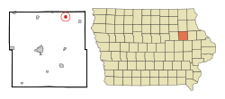
Location of Aurora, Iowa
|
|
| Country | |
| State | |
| County | Buchanan |
| Area | |
| • Total | 0.53 sq mi (1.37 km2) |
| • Land | 0.53 sq mi (1.37 km2) |
| • Water | 0.00 sq mi (0.00 km2) |
| Elevation | 1,138 ft (347 m) |
| Population
(2020)
|
|
| • Total | 169 |
| • Density | 319.47/sq mi (123.32/km2) |
| Time zone | UTC-6 (Central (CST)) |
| • Summer (DST) | UTC-5 (CDT) |
| ZIP code |
50607
|
| Area code(s) | 319 |
| FIPS code | 19-03835 |
| GNIS feature ID | 0454285 |
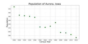
Aurora is a small city in Buchanan County, Iowa, United States. In the 2020 census, 169 people lived there. This was a bit less than the 194 people who lived there in 2000.
Contents
History of Aurora
Aurora was started in 1886 by a railroad company called the Chicago Great Western Railway. It officially became a city in 1899. The land for the town was given by a person named Bishop Warren and his wife, Alice. The city was named after Warren's hometown, East Aurora, New York.
Geography of Aurora
Aurora is located in Iowa. Its exact spot on a map is 42.618061 degrees north and -91.728519 degrees west.
The United States Census Bureau says that the city covers about 0.57 square miles (1.48 square kilometers). All of this area is land, with no water.
Population and People
| Historical population | |||
|---|---|---|---|
| Census | Pop. | %± | |
| 1900 | 331 | — | |
| 1910 | 287 | −13.3% | |
| 1920 | 284 | −1.0% | |
| 1930 | 281 | −1.1% | |
| 1940 | 276 | −1.8% | |
| 1950 | 225 | −18.5% | |
| 1960 | 223 | −0.9% | |
| 1970 | 229 | 2.7% | |
| 1980 | 248 | 8.3% | |
| 1990 | 196 | −21.0% | |
| 2000 | 194 | −1.0% | |
| 2010 | 185 | −4.6% | |
| 2020 | 169 | −8.6% | |
| U.S. Decennial Census | |||
What the 2020 Census Shows
A census is like a big count of all the people living in a place. The 2020 census found that 169 people lived in Aurora. There were 74 households, which are like homes where people live, and 52 families.
Most people in Aurora were White (about 94.7%). A small number were from other backgrounds. About 5.3% of the people were Hispanic or Latino.
The average age of people in Aurora was about 38.5 years old.
- About 27.8% of residents were under 20 years old.
- About 26.0% were between 25 and 44 years old.
- About 18.9% were 65 years old or older.
The city had slightly more females (50.9%) than males (49.1%).
Looking Back at the 2010 Census
In the 2010 census, there were 185 people living in Aurora. There were 79 households. Most people were White (95.1%). About 1.6% were Hispanic or Latino.
The average age in 2010 was 43.7 years. About 22.2% of residents were under 18. About 17.3% were 65 or older. In 2010, there were more males (54.1%) than females (45.9%).
Education in Aurora
Students in Aurora go to schools in the East Buchanan Community School District.
The very first school in Aurora was in the town hall building. A new school building was built in 1928. This school was part of the Aurora Independent School District.
In 1959, voters decided to combine schools from Aurora, Winthrop, and Quasqueton. This created the East Buchanan School District. Later, in 1966, Monti also joined this district.
Aurora used to have its own school in this district called North Elementary School. But fewer and fewer students attended. So, in May 1977, the school closed. The building was sold to the City of Aurora for just $1.00. After that, students from Aurora started taking buses to schools in Winthrop.
See also
 In Spanish: Aurora (Iowa) para niños
 | DeHart Hubbard |
 | Wilma Rudolph |
 | Jesse Owens |
 | Jackie Joyner-Kersee |
 | Major Taylor |


