
Independence, Iowa facts for kids
Quick facts for kids
Independence
|
|
|---|---|

Old Independence water tower
|
|
| Motto(s):
"Celebrate our spirit!"
|
|

Location of Independence, Iowa
|
|
| Country | United States |
| State | Iowa |
| County | Buchanan |
| Founded | June 15, 1847 |
| Incorporated | October 15, 1864 |
| Government | |
| • Type | Mayor–council government |
| Area | |
| • Total | 6.15 sq mi (15.93 km2) |
| • Land | 6.01 sq mi (15.57 km2) |
| • Water | 0.14 sq mi (0.36 km2) |
| Elevation | 935 ft (285 m) |
| Population
(2020)
|
|
| • Total | 6,064 |
| • Estimate
(2022)
|
6,179 |
| • Density | 1,008.65/sq mi (389.42/km2) |
| Time zone | UTC-6 (Central (CST)) |
| • Summer (DST) | UTC-5 (CDT) |
| ZIP code |
50644
|
| Area code(s) | 319 |
| FIPS code | 19-38100 |
| GNIS feature ID | 0457782 |

Independence is a city in Iowa, USA. It is the main city and county seat of Buchanan County. In 2020, about 6,064 people lived there.
Contents
History of Independence
Independence was started on June 15, 1847. It is located in the middle of Buchanan County today. The first town plan was a simple nine-block area. It was on the east side of the Wapsipinicon River. Leaders wanted Independence to be the new county seat. Before 1847, the main town was Quasqueton. When Independence became the county seat, fewer than 15 people lived there.
Early Buildings and Mills

In 1867, a tall six-story mill was built. It stood on Main Street, by the Wapsipinicon River. This mill is now called the Wapsipinicon Mill. Some stones for its base came from an older mill. That mill was called New Haven Mill. It was built in 1854 and used to process wool. Before Independence became an official city in 1864, there was a small village nearby. It was called New Haven, which is why the mill had that name. The Wapsipinicon Mill also made electricity from 1915 to 1940. Today, it has been fixed up and works as a history museum.
A courthouse was built in 1857. It was on the east side of town. People said it was on the "highest land nearby." From there, you could see the city and the Wapsipinicon Valley. This first courthouse was replaced in 1939. The new building was built in the Art Deco style.
Independence State Hospital
The Independence State Hospital has been in Independence for a long time. It is a large hospital located on the west side of town. The main building is called the Reynolds Building. It was built in 1873. It is made of "native prairie granite" and has a French Second Empire style. You can take tours of the building today.
Horse Racing Capital
For a few years in the late 1880s and early 1890s, Independence was famous for horse racing. Some people even called it the "Lexington of the North." This happened because of a man named Charles W. Williams. He was a telegraph operator and owned a creamery. In 1885, he bought two female horses. Each of them gave birth to a male horse within a year.
These two male horses were named Axtel and Allerton. They broke world records for trotting. Because of their success, Williams earned a lot of money. He started a racing newspaper called The American Trotter. He also built a large hotel and opera house called The Gedney. He even built a special figure-eight shaped race track. This track was on the west side of town at a place called Rush Park. There, he also built a huge horse barn and his family's mansion.
The town grew quickly. More mansions and churches were built. There was even a trolley-car service. Williams continued to raise other record-breaking horses. However, he lost much of his money during the Panic of 1893. Williams later moved away. Today, the area where Williams' race track was is now a corn field. His house is still there. But the Rush Park barn was torn down to build a fast-food restaurant and a car parts store. After the horse racing days, Independence became less important. This happened when the main railroad stop moved further west to Waterloo, Iowa.
Connection to Gertrude Stein
Independence has a surprising link to the American writer Gertrude Stein. She lived in Paris and was good friends with an American painter. His name was William Edwards Cook. He was born in Independence in 1881. Cook taught Stein how to drive. She used this skill to help the French during World War I.
In her book Everybody’s Autobiography, Stein wrote about how much she liked Iowa. She especially liked Cook's hometown, Independence, even though she had never visited it. As a child, she knew about the town's fame for horse racing. Her liking for Iowa also came from her friend Carl Van Vechten. He grew up in nearby Cedar Rapids, Iowa. He later became the person in charge of Stein's writings.
In 1933, Stein traveled across the U.S. to promote her books. She agreed to speak in Iowa City. She asked if she could fly over Independence to see Cook's birthplace from the air. Sadly, a big winter storm hit the Midwest that day. Stein's visit to Iowa was completely canceled.
Cook himself came back to Independence in 1925. He stayed for a while to help with his father's affairs. His father, an Independence lawyer, had died the year before. When Cook went back to Paris, he used some of his inheritance. He hired a young architect named Le Corbusier. Le Corbusier designed a house for Cook outside Paris. It is now known as one of the first Cubist houses. It is called Maison Cook or Villa Cook.
Bicycle Speed Record
The race track at Rush Park also holds a special record. In 1892, John S. Johnson set the first one-mile bicycle speed record there. He completed the mile in under two minutes.
Historic Buildings and Sites
Independence has several other important buildings. They have historical and architectural value.
- The Christian Seeland House and Brewery (1873) is an Italianate style mansion. It is located at 1010 4th Street Northeast.
- Saint John's Roman Catholic Church (1911) is at 2nd Street and 4th Avenue Northeast.
- The Munson Building (1893–95) was once the Independence Free Public Library. It is at 210 2nd Street Northeast.
- Saint James Episcopal Church (1863, 1873) is on 2nd Avenue Northeast. It is just north of 2nd Street.
- The United States Post Office Building (1934) is at 2nd Street and 2nd Avenue Northeast. Inside, there is a WPA mural from the 1930s. It is called Postman in the Snow. A former Independence resident named Robert Tabor painted it.
About 10 miles east of Independence is the Lowell Walter house. It is also known as Cedar Rock. This house was designed by Frank Lloyd Wright. It is owned by the state and open to visitors from May to October.
Geography and Climate
Geography of Independence
According to the United States Census Bureau, Independence covers about 6.22 square miles (16.11 square kilometers). Most of this area, about 6.08 square miles (15.75 square kilometers), is land. The rest, about 0.14 square miles (0.36 square kilometers), is water.
Climate in Independence
Independence has a hot-summer humid continental climate. This means it has warm, humid summers and cold winters. On climate maps, this is shown as "Dfa". The hottest temperature ever recorded in Independence was 108°F (42°C). This happened from July 12–14, 1936. The coldest temperature recorded was -32°F (-36°C). This happened on January 12, 1912.
| Climate data for Independence, Iowa, 1991–2020 normals, extremes 1883–2009 | |||||||||||||
|---|---|---|---|---|---|---|---|---|---|---|---|---|---|
| Month | Jan | Feb | Mar | Apr | May | Jun | Jul | Aug | Sep | Oct | Nov | Dec | Year |
| Record high °F (°C) | 61 (16) |
70 (21) |
88 (31) |
98 (37) |
104 (40) |
103 (39) |
108 (42) |
106 (41) |
100 (38) |
94 (34) |
81 (27) |
67 (19) |
108 (42) |
| Mean daily maximum °F (°C) | 26.5 (−3.1) |
30.8 (−0.7) |
44.2 (6.8) |
59.0 (15.0) |
70.8 (21.6) |
80.5 (26.9) |
83.0 (28.3) |
81.4 (27.4) |
74.9 (23.8) |
61.7 (16.5) |
45.9 (7.7) |
32.0 (0.0) |
57.6 (14.2) |
| Daily mean °F (°C) | 17.3 (−8.2) |
21.2 (−6.0) |
34.1 (1.2) |
47.3 (8.5) |
59.3 (15.2) |
69.8 (21.0) |
72.4 (22.4) |
70.4 (21.3) |
62.9 (17.2) |
50.0 (10.0) |
35.7 (2.1) |
23.3 (−4.8) |
47.0 (8.3) |
| Mean daily minimum °F (°C) | 8.0 (−13.3) |
11.7 (−11.3) |
23.9 (−4.5) |
35.5 (1.9) |
47.8 (8.8) |
59.2 (15.1) |
61.8 (16.6) |
59.4 (15.2) |
50.9 (10.5) |
38.3 (3.5) |
25.6 (−3.6) |
14.6 (−9.7) |
36.4 (2.4) |
| Record low °F (°C) | −32 (−36) |
−31 (−35) |
−30 (−34) |
−1 (−18) |
21 (−6) |
35 (2) |
40 (4) |
34 (1) |
18 (−8) |
2 (−17) |
−19 (−28) |
−27 (−33) |
−32 (−36) |
| Average precipitation inches (mm) | 0.95 (24) |
1.36 (35) |
2.02 (51) |
3.59 (91) |
4.60 (117) |
5.66 (144) |
4.61 (117) |
4.27 (108) |
3.53 (90) |
3.03 (77) |
2.09 (53) |
1.66 (42) |
37.37 (949) |
| Average snowfall inches (cm) | 10.0 (25) |
7.3 (19) |
3.8 (9.7) |
1.8 (4.6) |
0.0 (0.0) |
0.0 (0.0) |
0.0 (0.0) |
0.0 (0.0) |
0.0 (0.0) |
0.4 (1.0) |
3.0 (7.6) |
7.6 (19) |
33.9 (85.9) |
| Average precipitation days (≥ 0.01 in) | 7.6 | 7.1 | 8.1 | 9.9 | 12.2 | 11.0 | 9.0 | 8.7 | 7.6 | 8.7 | 7.5 | 7.9 | 105.3 |
| Average snowy days (≥ 0.1 in) | 5.6 | 4.5 | 2.6 | 1.0 | 0.0 | 0.0 | 0.0 | 0.0 | 0.0 | 0.2 | 1.7 | 5.5 | 21.1 |
| Source: NOAA | |||||||||||||
Population and People
How Many People Live Here?
| Historical population | |||
|---|---|---|---|
| Census | Pop. | %± | |
| 1860 | 1,395 | — | |
| 1870 | 2,945 | 111.1% | |
| 1880 | 3,128 | 6.2% | |
| 1890 | 3,163 | 1.1% | |
| 1900 | 3,656 | 15.6% | |
| 1910 | 3,517 | −3.8% | |
| 1920 | 3,672 | 4.4% | |
| 1930 | 3,691 | 0.5% | |
| 1940 | 4,342 | 17.6% | |
| 1950 | 4,865 | 12.0% | |
| 1960 | 5,498 | 13.0% | |
| 1970 | 5,910 | 7.5% | |
| 1980 | 6,392 | 8.2% | |
| 1990 | 5,972 | −6.6% | |
| 2000 | 6,014 | 0.7% | |
| 2010 | 5,966 | −0.8% | |
| 2020 | 6,064 | 1.6% | |
| 2022 (est.) | 6,179 | 3.6% | |
| U.S. Decennial Census Iowa State Data Center 2020 Census |
|||
2020 Census Information
In 2020, there were 6,064 people living in Independence. There were 2,625 households and 1,541 families. The city had about 1,008.6 people per square mile. Most residents, 94.5%, were White. About 0.6% were Black or African American, and 0.6% were Asian. People of Hispanic or Latino background made up 2.3% of the population.
About 27.7% of households had children under 18. Many households were married couples living together (44.3%). The average age in the city was 40.6 years. About 25.9% of residents were under 20 years old. And 20.7% were 65 years or older. The city had slightly more females (51.5%) than males (48.5%).
2010 Census Information
In 2010, Independence had 5,966 people. There were 2,521 households and 1,566 families. The population density was about 981.3 people per square mile. Most people (97.6%) were White. Hispanic or Latino people made up 1.2% of the population.
About 29.0% of households had children under 18. Many were married couples (48.7%). The average age was 41 years. About 23.9% of residents were under 18. And 19.7% were 65 or older. The city had 46.8% males and 53.2% females.
Fun Things to Do
Points of Interest in Independence

Independence offers many interesting places to visit:
- River'sEDGE Sport & Fitness (opened in 2014)
- Historic Downtown area
- Beautiful Riverside Parks
- Independence Family Aquatic Center (opened in 2017)
- Wapsipinicon Mill (a historic mill and museum)
- Independence State Hospital (a historic hospital on the edge of the city)
- Heartland Acres Agribition Center (a museum about farming history)
- Independence Motor Speedway (for racing fans)
- Independence Public Library
- Malek Theatre (a local theater)
- Illinois Central Station (a historic train station)
Education in Independence
Independence is part of the Independence Community School District. This district also includes the towns of Brandon and Rowley.
- East Elementary School teaches students from kindergarten to 2nd grade.
- West Elementary School teaches students from 3rd to 6th grade.
- The junior and senior high school teaches 7th to 12th grade.
There is also St. John Catholic School for local students. In 2011, the communities voted to build a new junior and senior high school. This new school, costing $27.5 million, opened in the fall of 2013.
City Services
Airport Information
Independence has a small municipal airport. Its official code is IIB. This airport offers flight training for those learning to fly. It also provides quick fueling services for planes. You can find charter flights and aircraft maintenance here. Hangar rental is also available for planes.
Famous People from Independence
Many notable people have come from Independence:
- Harry Chase – a 19th-century American marine artist.
- William Edwards Cook – an American artist who lived in other countries.
- Janet Dailey – a well-known novelist.
- Leonard Eugene Dickson – a famous mathematician.
- William G. Donnan – served in the Iowa Senate and the United States House of Representatives.
- Bill Gustoff – a member of the Iowa House of Representatives.
- Murray Joslin – an electrical engineer who helped a lot with nuclear power.
- William A. Noyes – a chemist who studied analytical and organic chemistry.
- Ulysses Prentiss Hedrick – a botanist and horticulturist who studied seed plants.
- Robert Byron Tabor – a painter.
- Harry E. Yarnell – a U.S. Navy admiral.
Images for kids
-
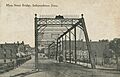
Main Street, 1900
-
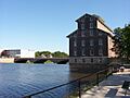
1867 Wapsipinicon Mill
-
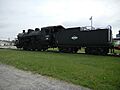
Illinois Central #30, a 0-8-0 steam locomotive on display in Independence
See also
 In Spanish: Independence (Iowa) para niños
