
Wapsipinicon River facts for kids
Quick facts for kids Wapsipinicon River |
|
|---|---|

Wapsipinicon River highlighted
|
|
| Other name(s) | Wapsie River, Wabespinicon River, Wapsiepinnecon River |
| Country | US |
| State | Iowa and Minnesota |
| District | Scott County, Iowa, Clinton County, Iowa, Cedar County, Iowa, Jones County, Iowa, Linn County, Iowa, Buchanan County, Iowa, Black Hawk County, Iowa, Bremer County, Iowa, Chickasaw County, Iowa, Howard County, Iowa, Mitchell County, Iowa, Mower County, Minnesota |
| Physical characteristics | |
| Main source | 3/4 mile south of Taopi, Minnesota 1,348 ft (411 m) 43°32′55″N 92°38′40″W / 43.54861°N 92.64444°W |
| River mouth | Mississippi River 574 ft (175 m) 41°43′47″N 90°19′11″W / 41.72972°N 90.31972°W |
| Length | 299.5 mi (482.0 km) |
The Wapsipinicon River (often called the Wapsi) is a river in the United States. It flows for about 300 miles (483 km) through southeastern Minnesota and northeastern Iowa. This river is a branch of the mighty Mississippi River. It helps drain a large area of farms, rolling hills, and bluffs.
Contents
Where Does the Wapsi River Flow?
The Wapsi River begins in Mower County, Minnesota. It then flows into Iowa in northern Mitchell County, Iowa. The river generally moves southeast. It passes through rural areas like Chickasaw County, Iowa, Bremer County, Iowa, and Buchanan County, Iowa.
It flows past towns such as Independence and Anamosa. For its last 25 miles (40 km), the river turns east. It forms the border between Clinton and Scott counties. Finally, it joins the Mississippi River from the west. This meeting point is about 10 miles (16 km) southwest of Clinton.
The Driftless Area
The Wapsipinicon River marks the western edge of a special area called the Driftless Area. This area is unique because glaciers did not flatten it. While the Wapsi's path is smooth, the Driftless Area has rugged canyons. These canyons drop steeply down to the Mississippi River.
What Does the Name "Wapsipinicon" Mean?
The name of the river comes from the Ojibwe language. In Ojibwe, it is Waabizipinikaan-ziibi. This means "river abundant in swan-potatoes."
Swan-potatoes (waabizipiniin) are a type of plant. They are also known as arrowheads or wild artichokes. Many of these plants used to grow near the river's banks.
The 1993 Flood
In 1993, the Wapsipinicon River experienced a large flood. This was part of bigger floods happening in the region. The high water caused a lot of damage. Many nearby farm fields were affected by the flooding.
Towns and Parks Along the Wapsi
The Wapsipinicon River flows past many cities and communities in Iowa. Some of these include McIntire, Riceville, Independence, Anamosa, and Wheatland.
Two state parks are located along the river. Cedar Rock State Park is near Quasqueton. Wapsipinicon State Park is on the southern bank at Anamosa. Many other local parks also border the river. These parks offer great places for people to visit and enjoy nature.
Fishing in the Wapsi River
The Wapsipinicon River is a popular spot for fishing. It is especially known for excellent catfish. The river also has many other types of fish. You can find northern pike, carp, sunfish, and walleye in different parts of the river.
Images for kids
-
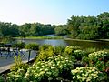
Wapsipinicon River in Independence, Buchanan County, Iowa
-
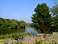
Wapsipinicon River in Buchanan County, Iowa


