
Crawford County, Wisconsin facts for kids
Quick facts for kids
Crawford County
|
|
|---|---|

|
|

Location within the U.S. state of Wisconsin
|
|
 Wisconsin's location within the U.S. |
|
| Country | |
| State | |
| Founded | 1818 |
| Named for | William H. Crawford |
| Seat | Prairie du Chien |
| Largest city | Prairie du Chien |
| Area | |
| • Total | 599 sq mi (1,550 km2) |
| • Land | 571 sq mi (1,480 km2) |
| • Water | 29 sq mi (80 km2) 4.8% |
| Population
(2020)
|
|
| • Total | 16,113 |
| • Estimate
(2023)
|
15,944 |
| • Density | 28.2/sq mi (10.9/km2) |
| Time zone | UTC−6 (Central) |
| • Summer (DST) | UTC−5 (CDT) |
| Congressional district | 3rd |
Crawford County is a county located in the southwest part of Wisconsin, a state in the United States. In 2020, about 16,113 people lived here. The main town and county seat is Prairie du Chien.
Contents
History of Crawford County
Crawford County is one of Wisconsin's very first counties. It was created in 1818 by the government of the Michigan Territory. This was before Wisconsin became its own territory or state. The county was named after William H. Crawford, who was an important government official at the time.
When it was first formed, Crawford County was much larger. It covered the entire western half of what is now Wisconsin. Over time, as more people moved in and new areas were settled, the county was divided into smaller parts. This happened especially in 1836 when the Wisconsin Territory was created.
Geography and Rivers
Crawford County covers about 599 square miles. Most of this area is land, with about 29 square miles being water. The highest point in the county is near St. James Church in a place called Rising Sun.
Three important rivers flow through or along the county:
- The Kickapoo River is often called "the crookedest river in Wisconsin." It was formed by water from melting glaciers long ago. It's a great place for paddling and is popular with kayakers and canoeists.
- The Wisconsin River forms the southern border of the county. Even though it's a busy river in the state, the part that runs through Crawford County is calm. You can see tall cliffs and sandy islands along its banks.
- The Mississippi River makes up the western border of the county. Along this river, you'll find steep limestone cliffs mixed with flat areas called prairies.
Neighboring Counties
Crawford County shares its borders with several other counties:
- Vernon County to the north
- Richland County to the east
- Grant County to the south
- Clayton County in Iowa to the southwest
- Allamakee County in Iowa to the west
People of Crawford County
| Historical population | |||
|---|---|---|---|
| Census | Pop. | %± | |
| 1840 | 1,502 | — | |
| 1850 | 2,498 | 66.3% | |
| 1860 | 8,068 | 223.0% | |
| 1870 | 13,075 | 62.1% | |
| 1880 | 15,644 | 19.6% | |
| 1890 | 15,987 | 2.2% | |
| 1900 | 17,286 | 8.1% | |
| 1910 | 16,288 | −5.8% | |
| 1920 | 16,772 | 3.0% | |
| 1930 | 16,781 | 0.1% | |
| 1940 | 18,328 | 9.2% | |
| 1950 | 17,652 | −3.7% | |
| 1960 | 16,351 | −7.4% | |
| 1970 | 15,252 | −6.7% | |
| 1980 | 16,556 | 8.5% | |
| 1990 | 15,940 | −3.7% | |
| 2000 | 17,243 | 8.2% | |
| 2010 | 16,644 | −3.5% | |
| 2020 | 16,113 | −3.2% | |
| U.S. Decennial Census 1790–1960 1900–1990 1990–2000 2010 2020 |
|||
In 2020, the population of Crawford County was 16,113 people. This means there were about 28 people living in each square mile. Most people living in the county were White (93.8%). About 1.6% of the population identified as Hispanic or Latino.
Many families in Crawford County have roots from different parts of the world. The largest groups of people by ancestry in 2020 were German, Irish, Norwegian, English, and Czech.
About 20% of households in the county had children under 18 living with them. Most households (49.3%) were married couples living together. The average age of people in the county was 47 years old. About 52% of the population was male and 48% was female.
Getting Around Crawford County
Main Roads

Several important highways run through Crawford County, helping people travel around:
 U.S. Highway 18
 U.S. Highway 61
 Highway 27 (Wisconsin)
 Highway 35 (Wisconsin)
 Highway 60 (Wisconsin)
 Highway 82 (Wisconsin)
 Highway 131 (Wisconsin)
 Highway 171 (Wisconsin)
 Highway 179 (Wisconsin)
Other Ways to Travel
- Railroads: Trains from BNSF and Wisconsin and Southern Railroad operate in the county.
- Buses: You can use the Scenic Mississippi Regional Transit bus service.
- Airport: The Prairie du Chien Municipal Airport (KPDC) serves the county and nearby towns.
Communities in Crawford County


Crawford County has several different types of communities:
Cities
- Prairie du Chien (This is the county seat, where the main government offices are.)
Villages
Towns
Unincorporated Communities
These are smaller communities that are not officially part of a city or village.
Education
Crawford County has several school districts that serve its communities:
- Boscobel Area School District
- De Soto Area School District
- Kickapoo Area School District
- North Crawford School District
- Prairie du Chien Area School District
- Riverdale School District
- Seneca School District
- Wauzeka-Steuben School District
Images for kids
-
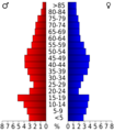
This chart shows the age groups of people living in Crawford County in 2000.

See also
 In Spanish: Condado de Crawford (Wisconsin) para niños
