Kickapoo River facts for kids
Quick facts for kids Kickapoo River |
|
|---|---|
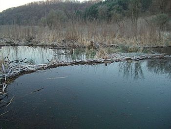
Beaver pond on Kickapoo River watershed, 2010
|
|
| Country | United States |
| State | Wisconsin |
| Region | Monroe County, Vernon County, Richland County, Crawford County |
| Physical characteristics | |
| Main source | Midway between Wilton and Mill Bluff State Park Monroe County, Wisconsin, United States 1,200 ft (370 m) 43°53′53″N 90°27′27″W / 43.89806°N 90.45750°W |
| River mouth | Confluence with the Wisconsin River Wauzeka, Wisconsin, Crawford County, Wisconsin 623 ft (190 m) 43°04′36″N 90°52′59″W / 43.07667°N 90.88306°W |
| Basin features | |
| Tributaries |
|
The Kickapoo River is a 126-mile-long (203 km) river in Wisconsin, United States. It flows into the Wisconsin River. The river is named after the Kickapoo Native American tribe. They lived in Wisconsin before settlers arrived in the early 1800s.
Contents
Where the Kickapoo River Flows
The Kickapoo River starts between Wilton, Wisconsin and Mill Bluff State Park. It flows south through a deep valley. This valley is part of the Driftless Zone in southwest Wisconsin. The river ends when it joins the Wisconsin River near Wauzeka, Wisconsin.
The name "Kickapoo" comes from an Algonquian word. It means "one who goes here, then there." This name fits the river well because it is very winding. It often turns back on itself as it flows. Even though the river is nearly 130 miles (210 km) long, its start and end points are only about 60 miles (97 km) apart in a straight line.
The Kickapoo River Watershed
The Kickapoo River is the longest river that flows into the Wisconsin River. It collects water from over 800 square miles (2,100 km2) of land. This area includes parts of Monroe, Vernon, Richland, and Crawford counties. The entire area that drains into the Kickapoo River is called its watershed. It covers about 492,000 acres (1,990 km2) in southwest Wisconsin.
Many smaller streams flow into the Kickapoo River. Some of the most important ones are Moore Creek, Billings Creek, the West Fork of the Kickapoo, Reads Creek, and Tainter Creek.
Most of the wetlands in the Kickapoo River watershed have been drained for farms. Wetlands now make up a very small part of the land, only 0.8%. Farming uses about 50.4% of the land. Forests cover a similar amount, about 48%.
Wildlife and Nature in the Kickapoo Valley
Two important protected areas are Wildcat Mountain State Park and the Kickapoo Valley Reserve. They create one large natural space. Many small streams and parts of the Kickapoo River itself are great places for trout. This is because cold water springs feed them. Also, projects over the years have helped improve the streams and surrounding land.
The river has over 500 miles (800 km) of coldwater streams. These streams are home to Brown trout (Salmo trutta) and Brook trout (Salvelinus fontinalis). About half of these trout populations reproduce naturally.
Beavers: Nature's Engineers
Recently, there was a movement to protect a family of beavers on Weister Creek. This creek flows into the Kickapoo River. Beavers are known as a keystone species. This means they play a very important role in their environment. They build dams, which create ponds and wetlands. These new watery areas help many different plants and animals to thrive.
Beaver ponds make the areas along rivers bigger. This allows more water plants to grow. More insects, fish, mammals, and birds can also live there. Beavers are especially helpful for birds. For example, Trumpeter swans (Cygnus buccaceus) and Canada geese (Branta canadensis) often build their nests on beaver lodges. When trees are flooded by beaver ponds, they become perfect nesting spots for birds that nest in tree holes. These include wood ducks (Aix sponsa), goldeneyes (Bucephala spp.), mergansers (Mergus spp.), and owls (Titonidae, Strigidae).
Studies have also shown that beaver ponds can help trout. They can increase the number of trout, their size, or both. For example, brown trout were found to be larger in beaver ponds compared to other parts of streams. Beaver ponds also provide important winter homes for trout, especially in shallow streams that might freeze solid. Even though beavers help trout and birds, the Wisconsin Department of Natural Resources sometimes suggests removing trees and brush from stream banks. This is done to reduce beaver activity in some areas of the Kickapoo River watershed.
The La Farge Dam Project
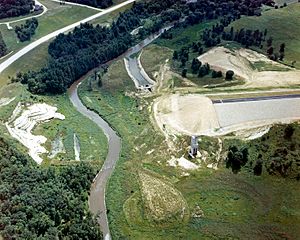
The Kickapoo River can flood easily after heavy rains. In the late 1960s, these floods led the U.S. Army Corps of Engineers to start building a dam. This dam was planned near La Farge, Wisconsin. The idea was to create a large lake, about 1,780 acres (7.2 km²) and 12 miles (19 km) long. This lake would help control flooding downstream.
To build the dam, the government bought 149 farms. This was about 8,569 acres (35 km²) of land. Many of the farmers did not want to sell their land. This land was either going to be flooded by the dam or used for a park around the new lake.
Construction of the dam began in 1971. However, people started to question the project. Environmental groups and some local residents worried about the dam's cost and its impact on nature. They were concerned about problems like the lake becoming polluted with too many nutrients. Wisconsin Senator Gaylord Nelson also opposed the project. After many lawsuits and studies, the government decided to stop building the dam in 1975. They had already spent over $19 million and built almost half of the dam. This left local residents still at risk of flooding. Later attempts to get support for a smaller dam also failed.
The 8,569 acres (35 km²) of land remained with the Army Corps of Engineers until 1996. Then, parts of the land were given to the state of Wisconsin and the Ho-Chunk Native American Tribe. Today, the Kickapoo River is a popular place for canoeing.
Flooding Challenges and Solutions
Even though flood control structures like dams can save lives and property, sometimes they can cause more problems. For example, dams can encourage people to build more homes and businesses downstream. If a dam breaks, the damage can be huge. Today, extreme weather events are happening more often and are stronger. This means flood control systems might not be able to handle them.
Because the La Farge dam project was stopped, the Kickapoo Valley still faces serious flooding. Major floods happened in 1978, 2007, and 2008.
Soldiers Grove: A New Approach
In the mid-1970s, the people of Soldiers Grove, Wisconsin decided to try something different. The Army Corps of Engineers wanted to build a wall (levee) around their village. Instead, the residents chose to move their main business area to higher ground. This relocation was finished a few years later. The new business district was built where floods could not reach it. It also used solar power for heating. This project became a national example of how to control floods without building large structures.
Soldiers Grove was barely damaged by the 2007 floods. These floods caused over $60 million in damage in the Kickapoo Valley. After the 2008 floods, other communities were told by the Federal Emergency Management Agency (FEMA) to move from their historic locations. This meant more residents had to relocate, even if they didn't want to.
Gays Mills: Moving to Safety
The Kickapoo River flooded in Gays Mills, Wisconsin in 2007 and again in 2008. The 2007 flood alone caused over $60 million in damage. After the 2008 floods, FEMA required communities like Gays Mills to move. This meant people had to leave their old homes and businesses. After several years of talks, the planned relocation of Gays Mills began in 2010.
 | Janet Taylor Pickett |
 | Synthia Saint James |
 | Howardena Pindell |
 | Faith Ringgold |


