
Vernon County, Wisconsin facts for kids
Quick facts for kids
Vernon County
|
|
|---|---|

Vernon County Courthouse in October 2015
|
|

Location within the U.S. state of Wisconsin
|
|
 Wisconsin's location within the U.S. |
|
| Country | |
| State | |
| Founded | 1851 |
| Named for | Mount Vernon |
| Seat | Viroqua |
| Largest city | Viroqua |
| Area | |
| • Total | 816 sq mi (2,110 km2) |
| • Land | 792 sq mi (2,050 km2) |
| • Water | 25 sq mi (60 km2) 3.0%% |
| Population
(2020)
|
|
| • Total | 30,714 |
| • Estimate
(2023)
|
31,170 |
| • Density | 37.640/sq mi (14.533/km2) |
| Time zone | UTC−6 (Central) |
| • Summer (DST) | UTC−5 (CDT) |
| Congressional district | 3rd |
Vernon County is a place in Wisconsin, a state in the United States. In 2020, about 30,714 people lived there. The main town, or county seat, is Viroqua.
Contents
History of Vernon County
Vernon County was first called Bad Ax County. This name was changed on March 22, 1862. Bad Ax County was created on March 1, 1851. It was made from parts of Richland and Crawford counties. The name Vernon was chosen for a special reason. It was picked to remind people of the county's green wheat fields. It also brought to mind Mount Vernon, a famous place.
Geography and Natural Features
The U.S. Census Bureau says Vernon County covers about 816 square miles. Most of this area, about 792 square miles, is land. The rest, about 25 square miles, is water. This means about 3% of the county is water.
Main Roads in Vernon County
 U.S. Highway 14
 U.S. Highway 61
 Highway 27 (Wisconsin)
 Highway 33 (Wisconsin)
 Highway 35 (Wisconsin)
 Highway 56 (Wisconsin)
 Highway 80 (Wisconsin)
 Highway 82 (Wisconsin)
 Highway 131 (Wisconsin)
 Highway 162 (Wisconsin)
Transportation Options
- BNSF (Trains)
- Scenic Mississippi Regional Transit (Buses)
Airports Serving the County
- Viroqua Municipal Airport (Y51) helps people travel by air.
- The Joshua Sanford Field airport used to be open but closed in 2016.
Neighboring Counties
Vernon County shares borders with several other counties:
- La Crosse County to the northwest
- Monroe County to the north
- Juneau County to the northeast
- Sauk County to the east
- Richland County to the southeast
- Crawford County to the south
- Allamakee County, Iowa to the southwest
- Houston County, Minnesota to the west
People and Religion in Vernon County
| Historical population | |||
|---|---|---|---|
| Census | Pop. | %± | |
| 1860 | 11,007 | — | |
| 1870 | 18,645 | 69.4% | |
| 1880 | 23,235 | 24.6% | |
| 1890 | 25,111 | 8.1% | |
| 1900 | 28,351 | 12.9% | |
| 1910 | 28,116 | −0.8% | |
| 1920 | 29,252 | 4.0% | |
| 1930 | 28,537 | −2.4% | |
| 1940 | 29,940 | 4.9% | |
| 1950 | 27,906 | −6.8% | |
| 1960 | 25,663 | −8.0% | |
| 1970 | 24,557 | −4.3% | |
| 1980 | 25,642 | 4.4% | |
| 1990 | 25,617 | −0.1% | |
| 2000 | 28,056 | 9.5% | |
| 2010 | 29,773 | 6.1% | |
| 2020 | 30,714 | 3.2% | |
| 2023 (est.) | 31,170 | 4.7% | |
| U.S. Decennial Census 1790–1960 1900–1990 1990–2000 2010–2020 |
|||
2020 Census Information
In 2020, the county had 30,714 people. There were about 38.8 people per square mile. Most people (95.4%) were White. A small number of people were Black (0.4%), Asian (0.3%), or Native American (0.2%). About 2.9% of people were from two or more races. About 1.5% of the population was Hispanic or Latino.
Religious Groups in Vernon County
Religion in Vernon County,according to ARDA (2020) Mainline Protestant Churches (21%) Evangelical Churches (14.7%) Anabaptist Churches (Amish and Mennonite) (11.8%) Catholic Church (6.8%) Others (1.1%) None (44.6%)
Economy and Jobs
Vernon County is home to the main office of Organic Valley. This is the world's largest group of family farmers working together.
Parks and Outdoor Fun
Vernon County has many parks run by the county and the state. The Kickapoo Valley Reserve is a huge natural area. It covers 8,600 acres and is located between La Farge and Ontario. Wildcat Mountain State Park is also found in the county.
County Parks and Forests
- Blackhawk Park
- Duck Egg County Forest
- Esofea/Rentz Memorial Park
- Jersey Valley Park
- Kooyumjian - Lost Creek County Forest
- Runge Hollow Recreation Area
- Sidie Hollow Park
- Wayside Park & Coon Prairie Trail
Communities in Vernon County
Cities
Villages
- Chaseburg
- Coon Valley
- De Soto (partly in Crawford County)
- Genoa
- La Farge
- Ontario
- Readstown
- Stoddard
- Viola (mostly in Richland County)
Towns
Unincorporated Communities
Gallery
-
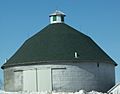
Round barn near Hillsboro
-
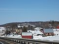
Farm and countryside near Hillsboro, along Wisconsin Highway 80
-
Vernon County jail in Viroqua, Wisconsin


See also
 In Spanish: Condado de Vernon (Wisconsin) para niños
