Richland County, Wisconsin facts for kids
Quick facts for kids
Richland County
|
|
|---|---|

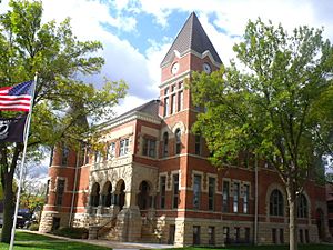
Richland County Courthouse
|
|

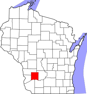
Location within the U.S. state of Wisconsin
|
|
 Wisconsin's location within the U.S. |
|
| Country | |
| State | |
| Founded | 1850 |
| Seat | Richland Center |
| Largest city | Richland Center |
| Area | |
| • Total | 589 sq mi (1,530 km2) |
| • Land | 586 sq mi (1,520 km2) |
| • Water | 3.1 sq mi (8 km2) 0.5%% |
| Population
(2020)
|
|
| • Total | 17,304 |
| • Estimate
(2023)
|
17,197 |
| • Density | 29.5/sq mi (11.4/km2) |
| Time zone | UTC−6 (Central) |
| • Summer (DST) | UTC−5 (CDT) |
| Congressional districts | 2nd, 3rd |
Richland County is a county located in the state of Wisconsin in the United States. It's like a large area or region within the state. In 2020, about 17,304 people lived here.
The main town and center of the county government is Richland Center. Richland County was first created in 1842 and officially started in 1850. It was named "Richland" because its soil is known for being very good and fertile.
Contents
Geography
Richland County covers a total area of about 589 square miles. Most of this area, around 586 square miles, is land. A small part, about 3.1 square miles, is water, like rivers or lakes.
Major Highways
Major highways are important roads that help people travel in and out of the county.
Airport
The Richland Airport (known as 93C) helps people travel by air. It serves Richland County and the towns nearby.
Neighboring Counties
Richland County shares its borders with these other counties:
- Vernon County – to the north
- Sauk County – to the east
- Iowa County – to the southeast
- Grant County – to the southwest
- Crawford County – to the west
Population Information
In 2020, the population of Richland County was 17,304 people. This means there were about 29.5 people living in each square mile. Most of the people living in the county are White (93.4%). Other groups include Black or African American (0.6%), Asian (0.6%), and Native American (0.3%). About 3.0% of the population is Hispanic or Latino.
Communities
Richland County has different types of communities, from cities to small, unincorporated areas.
City
- Richland Center (This is the county seat, meaning it's where the county government is located.)
Villages
- Boaz
- Cazenovia (partly in Sauk County)
- Lone Rock
- Viola (partly in Vernon County)
- Yuba
Towns
These are areas that include rural land and sometimes small communities.
Census-Designated Places
These are areas that are like towns but are not officially incorporated as cities or villages.
Unincorporated Communities
These are small communities or neighborhoods that are not part of an official city, village, or town government.
- Ash Ridge
- Aubrey
- Balmoral
- Basswood
- Bear Valley
- Bloom City
- Bosstown
- Buck Creek
- Bunker Hill
- Byrds Creek
- Eagle Corners
- Excelsior
- Five Points
- Germantown
- Gillingham
- Hub City
- Ithaca
- Jimtown
- Keyesville
- Loyd
- Neptune
- Nevels Corners
- Orion
- Port Andrew
- Rockbridge
- Sabin
- Sand Prairie
- Sylvan
- Tavera
- Tunnelville (partial)
- Twin Bluffs
- West Lima
- Westport
- Wild Rose
- Woodstock
Ghost Towns/Neighborhoods
These are places that used to be communities but are no longer populated.
See also
 In Spanish: Condado de Richland (Wisconsin) para niños
 | Selma Burke |
 | Pauline Powell Burns |
 | Frederick J. Brown |
 | Robert Blackburn |

