
Lone Rock, Wisconsin facts for kids
Quick facts for kids
Lone Rock, Wisconsin
|
|
|---|---|
|
Village
|
|

Village hall
|
|

Location of Lone Rock in Richland County, Wisconsin.
|
|
| Country | |
| State | |
| County | Richland |
| Area | |
| • Total | 1.00 sq mi (2.58 km2) |
| • Land | 1.00 sq mi (2.58 km2) |
| • Water | 0.00 sq mi (0.00 km2) |
| Elevation | 709 ft (216 m) |
| Population
(2010)
|
|
| • Total | 888 |
| • Estimate
(2019)
|
835 |
| • Density | 838.35/sq mi (323.69/km2) |
| Time zone | UTC-6 (Central (CST)) |
| • Summer (DST) | UTC-5 (CDT) |
| Area code(s) | 608 |
| FIPS code | 55-45575 |
| GNIS feature ID | 1568511 |
Lone Rock is a small village located in Richland County, Wisconsin, in the United States. In 2010, about 888 people lived there. The village gets its name from a large sandstone rock formation that used to stand nearby.
Contents
History of Lone Rock
The village of Lone Rock is named after a special rock. This huge piece of sandstone once stood close to the Wisconsin River. It was a famous landmark for people traveling on rafts down the river.
The community of Lone Rock started in 1856. It officially became a village in 1866. One well-known person from Lone Rock was Bertha E. Reynolds. People called her "Dr. Bertha." She was a doctor who helped the community in the early 1900s. Today, a park and a street in Lone Rock are named after her.
Geography of Lone Rock

Lone Rock is located in Wisconsin, on the north side of the Wisconsin River. You can find it where US Route 14 meets State Highway 130.
The village covers an area of about 2.58 square kilometers (1.00 square mile). All of this area is land, with no large bodies of water inside the village limits.

Climate
Lone Rock has a type of weather called a "hot-summer humid continental climate." This means it has warm, humid summers and cold, snowy winters.
The hottest temperature ever recorded in Lone Rock was 102 °F (39 °C). This happened in July 2012. The coldest temperature ever recorded was a very chilly -53 °F (-47 °C) in January 1951. For a while, Lone Rock held the record for the coldest temperature in Wisconsin!
Population Information
In 2010, Lone Rock had 888 people living in the village. There were 370 households, which are like homes where people live. About 244 of these households were families.
Most of the people living in Lone Rock were White (96.8%). A small number of people were from other racial backgrounds. About 1.9% of the population identified as Hispanic or Latino.
The average age of people in the village was 37 years old.
- About 26.4% of residents were under 18 years old.
- About 9.4% were between 18 and 24 years old.
- About 25.3% were between 25 and 44 years old.
- About 25.2% were between 45 and 64 years old.
- About 13.6% were 65 years or older.
There were slightly more males (52.4%) than females (47.6%) in the village.
Education
Lone Rock is part of the River Valley School District. Lone Rock Elementary School used to be in the village, but it closed in 2018.
Transportation
The Tri-County Regional Airport (KLNR) is nearby. It serves Lone Rock and the communities around it, helping people travel by air.
Images for kids
-
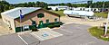
Village hall
-
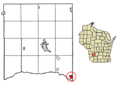
Location of Lone Rock in Richland County, Wisconsin.
See also
 In Spanish: Lone Rock (Wisconsin) para niños
