Mill Bluff State Park facts for kids
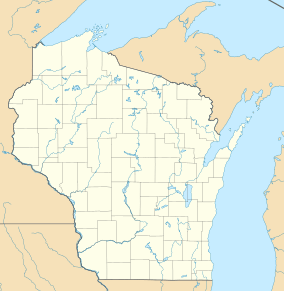
Mill Bluff State Park is a cool state park in central Wisconsin, United States. It's found in parts of Monroe and Juneau counties, close to the village of Camp Douglas. This park is part of the amazing Ice Age National Scientific Reserve.
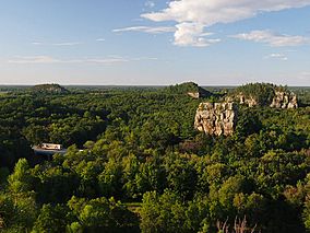
The park is famous for its tall sandstone bluffs. These bluffs are like giant rock towers, standing 80 feet (24 m) to 200 feet (61 m) high. They formed about 12,000 years ago in a huge ancient lake called Glacial Lake Wisconsin. Because of how they formed, these bluffs have steep, sharp sides. They look very different from the usual rounded hills you might see in the eastern U.S. For a long time, these bluffs have been important landmarks. Early pioneers used them to find their way, and today, travelers on Interstate 90/94 still see them as they pass through the park.
Contents
Exploring the Bluffs: What You'll See
Mill Bluff State Park has ten bluffs, each with its own name. The main one, Mill Bluff, stands about 120 feet (37 m) tall. It's located between the interstate highway and U.S. Route 12. The park office and campground are right at its base.
Bee Bluff is smaller, only about 60 feet (18 m) high, but it's easy to spot from the highway. It stands right next to the westbound lanes. Further north, you'll find Camels Bluff, which is about 170 feet (52 m) tall. It looks like two separate rock formations, just like the humps of a camel!
Close by are other interesting rock shapes. There's Devil's Monument and a tall, thin rock called Cleopatra's Needle, which is about 40 feet (12 m) high. Other bluffs in the park include Round Bluff and Sugar Bowl Bluff to the south. To the north, you'll find Wildcat Bluff (140 feet (43 m)) and Bear Bluff. Long Bluff, about 199 feet (61 m) tall, is to the northeast. Also in the northeast is Ragged Rock. This used to be a bluff, but its top layer wore away, and now it's slowly turning into a cone-shaped hill.
How the Bluffs Were Made: A Look at Geology
The bluffs at Mill Bluff State Park are made of sandstone that formed a very long time ago, during the Late Cambrian period. The top layer of each bluff is made of a harder type of sandstone. This tough cap helped protect the softer rock underneath from wearing away.
Most of Wisconsin was flattened by giant glaciers during the ice ages. However, these bluffs are in a special area called the Driftless Area. This part of the American Midwest was never covered by glaciers. Because of this, the bluffs were not pushed away or destroyed by ice.
During the last ice age, a huge tongue of ice blocked the Wisconsin River. This caused water to back up and form a massive body of water called Glacial Lake Wisconsin. Scientists believe the lake was about 60 to 80 feet (18 to 24 m) deep in this area. This meant the taller bluffs became islands, while the shorter ones were completely underwater. For about 3,000 years, waves in the lake crashed against the bluffs. This constant erosion shaped their distinctive steep sides. So, in a way, these bluffs are like sea stacks because they formed in a large body of water. The biggest ones are called mesas, the medium-sized ones are buttes, and the smallest is a pinnacle.
The flat ground in the park used to be the bottom of Glacial Lake Wisconsin. It's made of fine dirt and sand that settled there. You might even find some large rocks called glacial erratics. These rocks were carried by icebergs floating in the lake and then dropped when the ice melted.
The park is mostly covered by forests. You'll see trees like northern pin oak, jack pine, red pine, eastern white pine, and white oak.
A Glimpse into the Past: History of the Park

Some of the bluffs have ancient drawings called petroglyphs. These carvings, shaped like bird tracks, are about 400 years old. They are similar to the ones found at Roche-a-Cri State Park.
When settlers traveled west long ago, they often wrote about these bluffs in their diaries. Mill Bluff itself was named after a sawmill that used to operate nearby.
Mill Bluff and a small area around it officially became a state park on August 13, 1936. In May 1971, Mill Bluff State Park joined the Ice Age National Scientific Reserve. Later, the park was made bigger to include the other bluffs. In 2002, a special part of the park with all the main bluffs got even more protection. It was named the Mill Bluff State Natural Area.
Fun Things to Do at Mill Bluff State Park
Mill Bluff State Park is open from May to September. If you like hunting, small game hunting is allowed in some parts of the park from November 1 to December 15. Deer hunting is permitted for a shorter time.
The park has a small campground with 21 campsites. Six of these sites have electricity. The facilities are simple, with pit toilets and no showers. You can get drinking water from hand pumps.
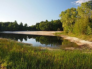
You can go swimming in a 2.5-acre (1.0 ha) lake south of the campground. This lake is fed by a natural spring. Sand has been added to create a 250-foot (76 m) beach for swimming.
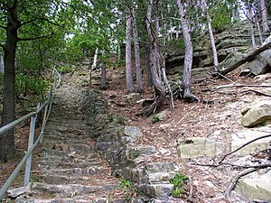
There's a 0.4-mile (640 m) nature trail that goes around the bottom of Mill Bluff. If you're feeling adventurous, you can climb 223 stone steps to the top of Mill Bluff. These steps were built a long time ago in the 1930s by a group called the Works Progress Administration.
About 0.8 miles (1.3 km) north on County Road W (also known as Funnel Road), there's a pullout for the Camels Bluff loop trail. This trail is about 1.25-mile (2.0 km) long. It takes you between the two parts of Camels Bluff and past the base of Devil's Monument and Cleopatra's Needle.
It's important to know that climbing on the bluffs is not allowed. This is because the sandstone is soft and the bluffs are very special geologically.
- Black, Robert F. Geology of the Ice Age National Scientific Reserve of Wisconsin. National Park Service Scientific Monograph, 1974. [1]
- Wisconsin Department of Natural Resources. Park brochure, signage, and the Wisconsin Department of Natural Resources website.
 | James Van Der Zee |
 | Alma Thomas |
 | Ellis Wilson |
 | Margaret Taylor-Burroughs |


