Asbury, Iowa facts for kids
Quick facts for kids
Asbury, Iowa
|
|
|---|---|
| Motto(s):
"You're Home."
|
|

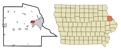
Location in the State of Iowa
|
|
| Country | |
| State | |
| County | Dubuque |
| Founded | 1830s |
| Incorporated | 1933 |
| Area | |
| • Total | 3.18 sq mi (8.22 km2) |
| • Land | 3.18 sq mi (8.22 km2) |
| • Water | 0.00 sq mi (0.00 km2) |
| Elevation | 932 ft (284 m) |
| Population
(2020)
|
|
| • Total | 5,943 |
| • Density | 1,871.22/sq mi (722.55/km2) |
| Time zone | UTC-6 (CST) |
| • Summer (DST) | UTC-5 (CDT) |
| ZIP code |
52002
|
| Area code(s) | 563 |
| FIPS code | 19-03160 |
| GNIS feature ID | 0454247 |
| Website | www.cityofasbury.com |
Asbury is a city in Dubuque County, Iowa, United States. It is located right next to the city of Dubuque. Asbury is part of the larger Dubuque metropolitan area. In 2020, about 5,943 people lived there.
Asbury is the second-largest city in Dubuque County. It grew quickly and became larger than Dyersville in 2010. The city is mostly a "bedroom community." This means many people who live in Asbury travel to work in nearby cities like Dubuque or Peosta.
Contents
Asbury's Story: From Small Town to Growing City
Asbury was first settled in the 1830s. Early settlers were often Methodists. The city is named after Bishop Francis Asbury. He was one of the first leaders of the Methodist Church in the United States.
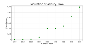
Asbury officially became a city in 1933. For a long time, Asbury was a very small town. In 1960, only 71 people lived there. But then, the nearby city of Dubuque started to grow a lot. This growth spread to the Asbury area in the 1960s.
By 1970, Asbury had 410 residents. It was the fastest-growing city in Iowa at that time! Asbury continues to grow quickly today. Since the year 2000, its population has increased by more than 50%. Many new housing areas are being built or planned.
Exploring Asbury's Location and Parks
Asbury is located at coordinates 42°30′56″N 90°45′48″W. The city covers a total area of about 3.18 square miles (8.22 square kilometers). All of this area is land.
The city has three parks and a walking trail for residents to enjoy. The parks are:
- Althaus Wetland & Nature Preserve
- Asbury Park
- Maple Hills Park
The trail connects Asbury Road to Maple Hills Park. It is part of Asbury's plan to create a city-wide network of trails.
How Asbury's Economy Works
Asbury mainly serves as a "bedroom community." This means most of its residents travel to work in Dubuque. Because of this, Asbury has a small local economy.
Only a few businesses operate within Asbury itself. However, this number has grown in recent years as the city's population has increased. Most people who work in Asbury are employed by the city government. Others work in service-related businesses along Asbury and Saratoga Roads.
Asbury's Population Over Time
| Historical populations | ||
|---|---|---|
| Year | Pop. | ±% |
| 1940 | 27 | — |
| 1950 | 52 | +92.6% |
| 1960 | 71 | +36.5% |
| 1970 | 410 | +477.5% |
| 1980 | 2,017 | +392.0% |
| 1990 | 2,013 | −0.2% |
| 2000 | 2,450 | +21.7% |
| 2010 | 4,170 | +70.2% |
| 2020 | 5,943 | +42.5% |
| Source: and Iowa Data Center Source: |
||
What the 2020 Census Shows
In 2020, Asbury had 5,943 people living there. There were 2,068 households and 1,659 families. The city had about 1,871 people per square mile.
Most residents (91.8%) were White. Other groups included Black or African American (1.7%) and Asian (2.0%). About 2.2% of the population was Hispanic or Latino.
Many households (41.4%) had children under 18. Most households (70.9%) were married couples living together. The average age in the city was 39.1 years. About 31.8% of residents were under 20 years old.
What the 2010 Census Showed
In 2010, Asbury had 4,170 people. There were 1,433 households and 1,164 families. The population density was about 1,568 people per square mile.
Most residents (96.8%) were White. Other groups included African American (1.0%) and Asian (1.1%). About 1.4% of the population was Hispanic or Latino.
Many households (45.4%) had children under 18. Most households (71.5%) were married couples. The average age was 35.6 years. About 32.9% of residents were under 18 years old.
Schools in Asbury
All students living in Asbury attend schools in the Dubuque Community School District.
- Elementary School: Students in central, eastern, and southern Asbury go to Carver Elementary School. Students in northern, western, and southwestern Asbury go to Kennedy Elementary School.
- Middle School: All Asbury middle school students attend Roosevelt Middle School.
- High School: All Asbury high school students go to Hempstead High School.
There are no private schools directly in Asbury. However, many students attend private schools in Dubuque. These schools are open to anyone, no matter where they live. Many students go to schools in the Holy Family Catholic School System. These include Resurrection Elementary School, Mazzuchelli Middle School, and Wahlert High School. There is also a private Lutheran elementary school in the area called Dubuque Lutheran School.
Asbury's Neighborhoods
Asbury is a city made up of many distinct neighborhoods. Since the city is quite new and has grown quickly, its different housing areas are still easy to identify. Generally, the eastern and southern parts of the city are older. The northern and western areas have mostly new homes.
Asbury Road is like the city's "main street." Most of the neighborhoods branch off from this road. The city is growing very fast. Since 2000, it has added 544 new single-family homes.
See also
 In Spanish: Asbury (Iowa) para niños
 | Delilah Pierce |
 | Gordon Parks |
 | Augusta Savage |
 | Charles Ethan Porter |


