
Sherrill, Iowa facts for kids
Quick facts for kids
Sherrill, Iowa
|
|
|---|---|

Sherrill seen from Lore Mound.
|
|

Location of Sherrill, Iowa
|
|
| Country | |
| State | |
| County | Dubuque |
| Area | |
| • Total | 0.13 sq mi (0.34 km2) |
| • Land | 0.13 sq mi (0.34 km2) |
| • Water | 0.00 sq mi (0.00 km2) |
| Elevation | 981 ft (299 m) |
| Population
(2020)
|
|
| • Total | 189 |
| • Density | 1,431.82/sq mi (551.28/km2) |
| Time zone | UTC-6 (Central (CST)) |
| • Summer (DST) | UTC-5 (CDT) |
| ZIP code |
52073
|
| Area code(s) | 563 |
| FIPS code | 19-72660 |
| GNIS feature ID | 0461574 |
Sherrill is a small city in Dubuque County, Iowa, United States. It's a quiet place with a population of 189 people, according to the 2020 census. This was a small increase from 186 people in 2000.
Contents
Discovering Sherrill's Past
Sherrill got its name from two brothers, Adam and Isaac Sherrill. It was first known as Sherrill's Mound or Mount. This is because the city sits at the bottom of a noticeable hill.
Early Buildings and Famous Visitors
In 1856, an Austrian immigrant named Peter Fries built a large stone inn. This inn was located at the main crossroads of the city. It became a popular spot, especially for newly married couples. There's even a story that the famous outlaw Jesse James and his gang stayed there. They were reportedly there before their well-known raid on Northfield, Minnesota. Today, this old building has been fixed up and is now called the Black Horse Inn.
German Heritage and Local Churches
During the 1800s, many German immigrants moved to Sherrill and the nearby countryside. They founded several churches that are still active today. These include German Catholic (SS. Peter and Paul), German Lutheran (St. Matthew), German Methodist, and German Evangelical churches.
Sherrill's "Beer Town" History
In 1933, Sherrill became one of ten "Beer Towns" in Dubuque County. This happened so that local taverns could legally serve beer. It was believed that only places inside incorporated cities could get beer licenses. Sherrill's post office was set up in 1858, with Peter Fries as the first postmaster. The city's ZIP code is 52073.
Exploring Sherrill's Location
Sherrill is located at 42°36′10″N 90°46′56″W / 42.60278°N 90.78222°W. This means it's in the northern part of the United States.
City Size and Land Area
The United States Census Bureau reports that Sherrill covers a total area of about 0.13 square miles (0.34 square kilometers). All of this area is land, meaning there are no large bodies of water within the city limits.
Understanding Sherrill's Population
| Historical populations | ||
|---|---|---|
| Year | Pop. | ±% |
| 1940 | 82 | — |
| 1950 | 162 | +97.6% |
| 1960 | 174 | +7.4% |
| 1970 | 190 | +9.2% |
| 1980 | 208 | +9.5% |
| 1990 | 148 | −28.8% |
| 2000 | 186 | +25.7% |
| 2010 | 177 | −4.8% |
| 2020 | 189 | +6.8% |
| Source: and Iowa Data Center Source: |
||
2020 Population Details
In 2020, the census counted 189 people living in Sherrill. There were 77 households, and 63 of these were families. Most of the people living in Sherrill were White.
Many households, about 39%, had children under 18 living with them. Most households (62.3%) were married couples living together. About 18.2% of all households were not families.
The average age of people in Sherrill was 36.4 years old. About 28% of residents were under 20 years old. Also, 16.4% were 65 years old or older. The population was almost evenly split between males (49.2%) and females (50.8%).
2010 Population Details
The 2010 census showed 177 people living in Sherrill. There were 73 households and 54 families. Most of the people were White (94.9%).
About 31.5% of households had children under 18. Most households (63%) were married couples. The average household had 2.42 people. The average family had 2.89 people.
The median age in 2010 was 42.5 years. About 23.7% of residents were under 18. Also, 23.2% were 65 years or older. There were slightly more males (52.5%) than females (47.5%) in the city.
Images for kids
-
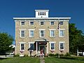
Black Horse Inn, originally the Sherrill Mount House
-
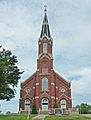
SS. Peter and Paul Catholic Church
-
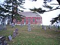
SS. Peter and Paul viewed from the cemetery
-
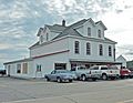
The Barn Bar


See also
 In Spanish: Sherrill (Iowa) para niños
