
Charles Mound facts for kids
Quick facts for kids Charles Mound |
|
|---|---|

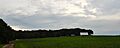
Looking eastward at Charles Mound, the highest point in Illinois from Elizabeth Scales Mound Road, September 2016
|
|
| Highest point | |
| Elevation | 1,235 ft (376 m) NAVD 88 |
| Prominence | 95 ft (29 m) |
| Listing | U.S. state high points 45th |
| Geography | |

Charles Mound
Location in Illinois
|
|
| Location | Jo Daviess County, Illinois, United States |
| Topo map | USGS Shullsburg |
Charles Mound is a gentle hill in northern Illinois, United States. It stands 1,235-foot (376 m) tall. This makes it the highest natural point in the entire state! It's located near the small town of Scales Mound. People who enjoy visiting the highest points in different states call places like Charles Mound a "highpoint."
Contents
Exploring Charles Mound's Geography
Charles Mound is the highest natural spot in Illinois. While it's the highest natural point, the very highest point in Illinois is actually the top of the Willis Tower (which used to be called the Sears Tower) in Chicago. The top of Charles Mound is only about 0.25 miles (400 m) from the Wisconsin border.
The Driftless Area Mystery
Charles Mound is part of a special area called the Driftless Area. This region includes parts of Illinois, Iowa, Minnesota, and Wisconsin. What makes it special? Unlike most of the surrounding land, this area was not flattened or changed by the huge sheets of ice (glaciers) that covered much of North America a long time ago. Because of this, the Driftless Area has unique hills and valleys. Charles Mound itself is a "remnant" hill. This means it's a piece of land that was left behind after the surrounding softer land wore away over time.
Soil and Surroundings
The soil at the very top of Charles Mound is a type called Elizabeth silt loam. The areas around the mound have a slightly different soil. This soil is deeper and known as silty clay loam from the Lacrescent series.
Who Was Charles Mound Named After?
The hill gets its name from Elijah Charles. He was one of the first people to settle permanently in this region. Elijah Charles arrived in 1828 and built his home at the base of this mound. That's how the hill came to be known as Charles Mound.
Visiting Charles Mound
Charles Mound is located on private farmland. The owners, Jean and Wayne Wuebbels, are very kind. They allow people to visit their property on specific days. You can access Charles Mound on the first full weekends of June, July, August, and September.
Images for kids
-
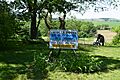
Sign at the summit of Charles Mound, June 2016
-
Charles Mound, July 2014

