Scales Mound, Illinois facts for kids
Quick facts for kids
Scales Mound
|
|
|---|---|

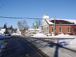
Scales Mound - Franklin Street in winter 2008
|
|
| Motto(s):
At the Top of Illinois
|
|

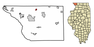
Location of Scales Mound in Daviess County, Illinois
|
|

Location of Illinois in the United States
|
|
| Country | United States |
| State | Illinois |
| County | Jo Daviess |
| Township | Scales Mound |
| Area | |
| • Total | 0.63 sq mi (1.63 km2) |
| • Land | 0.63 sq mi (1.63 km2) |
| • Water | 0.00 sq mi (0.00 km2) |
| Elevation | 955 ft (291 m) |
| Population
(2020)
|
|
| • Total | 436 |
| • Density | 694.27/sq mi (267.89/km2) |
| Time zone | UTC-6 (CST) |
| • Summer (DST) | UTC-5 (CDT) |
| ZIP Code(s) |
61075
|
| Area code(s) | 815 |
| FIPS code | 17-67925 |
| Wikimedia Commons | Scales Mound, Illinois |
| Website | http://scalesmound.com |
Scales Mound is a small village located in Jo Daviess County, Illinois, United States. In 2020, about 436 people lived there.
Contents
A Look at Scales Mound's History
The first Scales Mound town was near a hill, similar to Charles Mound. This spot was about a mile southwest of where the village is today. In 1830, a man named Samuel Scales bought this land. He built a tavern there, which was a popular stop along a main travel route called Sucker Trail.
The land for the current village was bought from the U.S. government in 1848. Not much is known about what happened on this land until the 1850s.
How the Railroad Shaped Scales Mound
In 1851, the Illinois Central Railroad (ICRR) was created. This railroad played a huge part in helping many rural towns in Illinois grow, including Scales Mound. In September 1853, two men, Josiah Conlee and B.B. Provost, planned out the village of Scales Mound. They knew the railroad was coming soon.
By the summer of 1854, ICRR workers had laid about 20 miles (32 km) of track. This track connected Scales Mound to Apple River. Trains started running on this line the very next day after it was finished! With the railroad's arrival, Scales Mound got its first building. It was a store built by Sherman Eddy in late 1854.
Population and People of Scales Mound
| Historical population | |||
|---|---|---|---|
| Census | Pop. | %± | |
| 1880 | 311 | — | |
| 1900 | 418 | — | |
| 1910 | 388 | −7.2% | |
| 1920 | 356 | −8.2% | |
| 1930 | 348 | −2.2% | |
| 1940 | 354 | 1.7% | |
| 1950 | 385 | 8.8% | |
| 1960 | 399 | 3.6% | |
| 1970 | 382 | −4.3% | |
| 1980 | 347 | −9.2% | |
| 1990 | 388 | 11.8% | |
| 2000 | 401 | 3.4% | |
| 2010 | 376 | −6.2% | |
| 2020 | 436 | 16.0% | |
| U.S. Decennial Census | |||
In 2000, there were 401 people living in Scales Mound. These people lived in 164 homes, and 108 of these were families. About 31% of homes had children under 18. Most homes (54%) were married couples living together.
The people in the village were of different ages. About 25% were under 18. Around 26% were between 25 and 44 years old. About 20% were 65 years or older. The average age in the village was 38 years.
Exploring Scales Mound's Geography
Where is Scales Mound Located?
Scales Mound is in the northwestern part of Illinois. It's in Jo Daviess County, which is part of a special area called the Driftless Area. The village is located at 42°28′41″N 90°15′2″W / 42.47806°N 90.25056°W. It's also very close to Charles Mound, which is the highest natural point in Illinois. Scales Mound is also found along the Stagecoach Trail. The village even has an annual festival called Stagecoach Trail Days.
Understanding the Land Around Scales Mound
Scales Mound is in the Driftless Area of the U.S. Midwest. This area is special because it was not covered by glaciers during the last ice age. This means the land looks different from other parts of the Midwest. The Driftless Area includes parts of Illinois, Wisconsin, Minnesota, and Iowa.
In Illinois, this unique land is mostly in Jo Daviess County. The area has many hills and wooded ridges. You can find canyons, bluffs, ravines, and palisades here. Because it's so close to Charles Mound, the highest point in Illinois (1235 feet), Scales Mound is known as being "At the Top of Illinois."
Scales Mound's Climate
| Climate data for Scales Mound, Illinois | |||||||||||||
|---|---|---|---|---|---|---|---|---|---|---|---|---|---|
| Month | Jan | Feb | Mar | Apr | May | Jun | Jul | Aug | Sep | Oct | Nov | Dec | Year |
| Mean daily maximum °F (°C) | 27 (−3) |
34 (1) |
45 (7) |
59 (15) |
72 (22) |
81 (27) |
84 (29) |
81 (27) |
73 (23) |
63 (17) |
46 (8) |
34 (1) |
58 (15) |
| Mean daily minimum °F (°C) | 3 (−16) |
10 (−12) |
21 (−6) |
32 (0) |
43 (6) |
54 (12) |
57 (14) |
55 (13) |
46 (8) |
34 (1) |
25 (−4) |
12 (−11) |
33 (0) |
| Average precipitation inches (mm) | 1.12 (28.4) |
1.24 (31.5) |
2.58 (65.5) |
3.38 (85.9) |
3.57 (90.7) |
5.07 (128.8) |
2.90 (73.7) |
4.4 (113) |
3.63 (92.2) |
2.51 (63.8) |
2.71 (68.8) |
1.8 (45) |
34.91 (887.3) |
| Source: weather.com | |||||||||||||
Education in Scales Mound
Scales Mound has one school that teaches students from kindergarten all the way through 12th grade. This includes high school. The school's mascot is the Hornet.
Culture and Local Attractions
See also
 In Spanish: Scales Mound para niños
 | Bessie Coleman |
 | Spann Watson |
 | Jill E. Brown |
 | Sherman W. White |


