
Platteville, Wisconsin facts for kids
Quick facts for kids
Platteville, Wisconsin
|
|
|---|---|
|
Main Street
City Hall Park
Pine Street
Roundtree Trail
Firefighter Memorial Statue
|
|

Location of Platteville in Grant County, Wisconsin.
|
|
| Country | |
| State | |
| County | Grant |
| Area | |
| • City | 6.18 sq mi (16.00 km2) |
| • Land | 6.18 sq mi (16.00 km2) |
| • Water | 0.00 sq mi (0.00 km2) |
| Elevation | 991 ft (302 m) |
| Population
(2020)
|
|
| • City | 11,836 |
| • Estimate
(2021)
|
11,764 |
| • Density | 1,915.2/sq mi (739.75/km2) |
| • Metro | 49,681 |
| Time zone | UTC-6 (CST) |
| • Summer (DST) | UTC-5 (CDT) |
| ZIP code |
53818
|
| Area code(s) | 608 |
| FIPS code | 55-63250 |
| Website | http://www.platteville.org/ |


Platteville is the biggest city in Grant County, Wisconsin, United States. In 2020, about 11,836 people lived there.
Platteville is located in the southern Driftless Region of Wisconsin. This area is special because it was not flattened by glaciers long ago. It has rolling hills and unique karst topography, which means there are caves and sinkholes. Platteville is also home to the University of Wisconsin–Platteville. It is the main city in the Platteville micropolitan statistical area, which is a group of nearby towns and cities with a total population of about 51,938 people.
Contents
History of Platteville
Platteville was first settled by pioneers and early lead miners. They built homes near the Rountree Branch and Little Platte River. These rivers flow into the larger Upper Mississippi River system. The city is in the Driftless Region of Southwestern Wisconsin.
Because of the hilly land, some streets in Platteville are not straight. As the town grew, roads were built in unusual ways to avoid steep valleys and old mining shafts.
Early Days and Lead Mining
Platteville was officially started in 1829 by John H. Rountree. He was a businessman from the South who came hoping to find wealth during the area's "lead rush." The town became a busy mining community. This was partly because it was close to Dubuque, Iowa, and Galena, Illinois. These were growing cities on the Mississippi River that needed lead from the 1820s to the 1850s.
Some wealthy people, like John H. Rountree and Wisconsin’s first Governor Henry Dodge, brought enslaved people with them during the lead rush. They also brought free Black workers. Even though unpaid labor was against the law, it happened in the region until after the Civil War.
In 1850, a free African-American man named Charles Shepard started a community called Pleasant Ridge, Grant County, Wisconsin. It was just west of Platteville. This place was a safe spot for many Black people traveling north from states like Arkansas and Louisiana. Some stayed and built lives, while others continued their journey.
Growth and Education
By the 1860s, lead mining was slowing down. But zinc mining quickly took its place. Platteville had become a well-established town. It had schools, a private academy, a newspaper, churches, and even a telegraph service by 1849.

During this time, two important colleges were started. A teachers' college opened in 1866 to train teachers for elementary schools. The Wisconsin Mining Trade School opened in 1908.
In 1959, these two colleges joined together. They became Wisconsin State College and Institute of Technology. They added more programs, especially in engineering. In 1971, it was renamed the University of Wisconsin–Platteville. This new name showed that it offered more advanced studies. Today, UW-Platteville is known for its excellent criminal justice program.
From 1984 to 2001, the Chicago Bears football team held their summer training camp at the University of Wisconsin–Platteville. This brought a lot of money to the town each summer. The town felt the loss when the Bears moved their camp to Illinois.
In 2004, U.S. Highway 151 was improved to be a faster highway that went around the city. This change affected how Platteville grew. A new hospital was built near the highway exits. Also, a Walmart Supercenter and a Menards store opened nearby.
Historic Buildings in Platteville
-
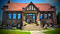
Former Carnegie library building
-
Ullrich Hall, part of the University of Wisconsin-Platteville


Geography of Platteville

Platteville is located in the "Hollow Region," as early miners called it. This area has rolling hills in southwestern Wisconsin.
The city covers about 6.18 square miles (16.00 square kilometers) of land.
Platteville is served by Wisconsin State Highways 80 and 81. It is also connected by U.S. Highway 151.
The ground in this area has minerals like galena, which is a lead sulfide. Zinc sulfide, also called sphalerite, is also common. Lead and zinc mining were very active from the 1820s to the 1920s.
Platteville's Climate
| Climate data for Platteville, Wisconsin (1991–2020 normals, extremes 1872–present) | |||||||||||||
|---|---|---|---|---|---|---|---|---|---|---|---|---|---|
| Month | Jan | Feb | Mar | Apr | May | Jun | Jul | Aug | Sep | Oct | Nov | Dec | Year |
| Record high °F (°C) | 57 (14) |
65 (18) |
84 (29) |
93 (34) |
107 (42) |
102 (39) |
108 (42) |
105 (41) |
101 (38) |
93 (34) |
80 (27) |
67 (19) |
108 (42) |
| Mean daily maximum °F (°C) | 25.7 (−3.5) |
30.8 (−0.7) |
43.3 (6.3) |
57.1 (13.9) |
68.7 (20.4) |
78.2 (25.7) |
81.8 (27.7) |
80.1 (26.7) |
73.2 (22.9) |
60.3 (15.7) |
44.6 (7.0) |
31.6 (−0.2) |
56.3 (13.5) |
| Daily mean °F (°C) | 17.8 (−7.9) |
22.3 (−5.4) |
34.1 (1.2) |
46.3 (7.9) |
57.9 (14.4) |
68.2 (20.1) |
71.8 (22.1) |
70.0 (21.1) |
62.2 (16.8) |
49.7 (9.8) |
36.3 (2.4) |
24.2 (−4.3) |
46.7 (8.2) |
| Mean daily minimum °F (°C) | 9.9 (−12.3) |
13.7 (−10.2) |
24.8 (−4.0) |
35.4 (1.9) |
47.1 (8.4) |
58.3 (14.6) |
61.8 (16.6) |
59.8 (15.4) |
51.2 (10.7) |
39.1 (3.9) |
28.0 (−2.2) |
16.7 (−8.5) |
37.1 (2.8) |
| Record low °F (°C) | −43 (−42) |
−36 (−38) |
−28 (−33) |
7 (−14) |
26 (−3) |
33 (1) |
44 (7) |
35 (2) |
24 (−4) |
6 (−14) |
−21 (−29) |
−37 (−38) |
−43 (−42) |
| Average precipitation inches (mm) | 1.22 (31) |
1.47 (37) |
2.09 (53) |
3.95 (100) |
4.65 (118) |
5.97 (152) |
5.29 (134) |
4.23 (107) |
4.25 (108) |
2.82 (72) |
2.25 (57) |
1.79 (45) |
39.98 (1,015) |
| Average snowfall inches (cm) | 11.0 (28) |
9.8 (25) |
6.1 (15) |
1.6 (4.1) |
0.1 (0.25) |
0.0 (0.0) |
0.0 (0.0) |
0.0 (0.0) |
0.0 (0.0) |
0.4 (1.0) |
1.9 (4.8) |
11.9 (30) |
42.8 (109) |
| Average precipitation days (≥ 0.01 in) | 9.0 | 7.9 | 9.0 | 11.2 | 12.8 | 12.2 | 10.5 | 9.7 | 8.8 | 9.7 | 8.6 | 9.4 | 118.8 |
| Average snowy days (≥ 0.1 in) | 6.8 | 5.7 | 3.4 | 0.8 | 0.0 | 0.0 | 0.0 | 0.0 | 0.0 | 0.2 | 1.4 | 6.4 | 24.7 |
| Source: NOAA | |||||||||||||
Platteville's Population
| Historical population | |||
|---|---|---|---|
| Census | Pop. | %± | |
| 1870 | 2,537 | — | |
| 1880 | 2,687 | 5.9% | |
| 1890 | 2,740 | 2.0% | |
| 1900 | 3,340 | 21.9% | |
| 1910 | 4,452 | 33.3% | |
| 1920 | 4,353 | −2.2% | |
| 1930 | 4,047 | −7.0% | |
| 1940 | 4,762 | 17.7% | |
| 1950 | 5,751 | 20.8% | |
| 1960 | 6,957 | 21.0% | |
| 1970 | 9,599 | 38.0% | |
| 1980 | 9,580 | −0.2% | |
| 1990 | 9,708 | 1.3% | |
| 2000 | 9,989 | 2.9% | |
| 2010 | 11,224 | 12.4% | |
| 2020 | 11,836 | 5.5% | |
| 2021 (est.) | 11,764 | 4.8% | |
| U.S. Decennial Census | |||
2020 Census Information
In 2020, the population of Platteville was 11,836 people. This means there were about 1,915.8 people per square mile. There were 4,423 homes, with about 715.9 homes per square mile.
Most people in the city (90.9%) were White. About 2.2% were Black or African American, and 2.0% were Asian. A small number (0.2%) were Native American, and 1.2% were from other races. About 3.4% of people were from two or more races. About 3.1% of the population was Hispanic or Latino.
The 2020 census counted 2,858 students living in college housing.
From 2016 to 2020, the average income for a household in Platteville was $42,626. For families, the average income was $75,625. The average income per person in the city was $20,781. About 7.5% of families and 30.0% of all people lived below the poverty line. This included 16.4% of those under 18 and 13.8% of those 65 or older.
Most adults (95.1%) had finished high school or more. About 41.8% had earned a bachelor's degree or higher.
Arts and Culture in Platteville

The Mining and Rollo Jamison Museums teach visitors about Platteville's history of mining.
The Stone Cottage was built in 1837 by Reverend Samuel Mitchell. It still has many of its original furnishings. This home belonged to Major John Rountree, one of Platteville's founders. Its walls are two feet thick and made of strong dolomite Galena limestone.
The Platte Mound M is a giant letter "M" made from whitewashed stones on Platte Mound. It is about four miles east of downtown Platteville. This "M" is the largest hillside letter "M" in the world! It is 241 feet (73 meters) high and 214 feet (65 meters) wide. Its legs are 25 feet (7.6 meters) wide.
Education in Platteville


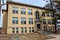
The Platteville School District serves the Platteville area. Platteville High School is the public high school for the area. Its mascot is "Henry Hillmen." The University of Wisconsin–Platteville is also located in Platteville.
Transportation in Platteville

Platteville has the Platteville Municipal Airport (KPVB). This airport is used for smaller planes and serves the city and nearby communities. For bigger commercial flights, the closest airport is Dubuque Regional Airport. For international flights, the closest major airport is Chicago O'Hare International Airport.
The main road to Platteville is U.S. Route 151. This highway acts like a fast expressway for the region. US 151 has three exits near the city center. Wisconsin state routes 80 and 81 also go through Platteville. They run through the main business area like a "main street."
Platteville Public Transportation offers bus service and special transportation for people who need it.
Platteville no longer has train service. It used to be served by the Chicago and Northwestern Railway (C&NW) and the Milwaukee Road. Passenger train service ended in the 1950s. Freight train service continued until the lines were removed in the 1970s and 1980s. This ended all train service to Platteville.
Notable People from Platteville
Politicians
- William Carter, a state representative in Wisconsin.
- S. Wesley Clark, who was the Attorney General of South Dakota.
- Kearton Coates, a state representative in Wisconsin.
- Thomas Cruson, a legislator in the Wisconsin Territory.
- James Dolan, a state representative in Wisconsin.
- Ensign Dickinson, a state representative in Wisconsin.
- Charles E. Estabrook, who was the Wisconsin Attorney General.
- Neely Gray, a Wisconsin territorial legislator and businessman.
- John L. Grindell, a state representative in Wisconsin.
- Jon R. Guiles, a state representative in Wisconsin.
- James V. Holland, a state representative in Wisconsin.
- Thomas Jenkins, a state representative in Wisconsin.
- Arthur W. Kopp, a U.S. Representative.
- James B. McCoy, a state representative in Wisconsin.
- Duncan McGregor, a state representative in Wisconsin.
- Ray Meiklejohn, a Canadian politician.
- Christopher C. Miller, who was the Acting United States Secretary of Defense.
- Jonathan Baker Moore, a state representative in Wisconsin and a general in the Union Army.
- James William Murphy, a U.S. Representative.
- Edward Rawlings, a state representative in Iowa.
- Hanmer Robbins, a state representative in Wisconsin.
- Gordon Roseleip, a state senator in Wisconsin.
- John H. Rountree, a state senator in Wisconsin.
- A. C. Schultz, a state representative in Wisconsin.
- George Slack, a state representative in Wisconsin.
- Harry E. Stephens, a state representative in Wisconsin.
- Robert S. Travis, a state senator in Wisconsin.
- Adelbert L. Utt, a state representative in Wisconsin.
- James Russell Vineyard, a politician in Wisconsin and California.
- Noah Virgin, a state senator in Wisconsin.
- Benjamin Webster, a state representative in Wisconsin.
- Conrad J. Weittenhiller, a state representative in Wisconsin.
Other Famous People
- Scott Adams, an early computer game designer.
- John Fiedler, a voice actor and character actor in movies, TV, and radio.
- Herbert Spencer Gasser, a physiologist who won the Nobel Prize for Physiology or Medicine in 1944.
- Geoff Herbach, a novelist (writer of books).
- Cosette Kies, a librarian, writer, and professor.
- Herbert T. Perrin, a U.S. Brigadier General who received the Distinguished Service Cross.
- Josiah Little Pickard, an educator (teacher/school leader).
- Pants Rowland, manager of the 1917 World Series champion Chicago White Sox baseball team.
Sister City
Images for kids
-
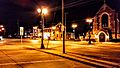
Downtown Platteville at night
-
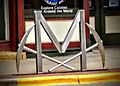
Bike rack depicting the Big M
-
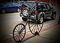
Bike rack in downtown Platteville
-
Rountree Hall apartment complex (former Mining school)
-
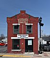
The William Parnell Building, part of the Main Street Commercial Historic District


See also
 In Spanish: Platteville (ciudad, condado de Grant, Wisconsin) para niños
