
Putnam County, Illinois facts for kids
Quick facts for kids
Putnam County
|
|
|---|---|

Putnam County Courthouse, Hennepin
|
|

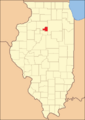
Location within the U.S. state of Illinois
|
|
 Illinois's location within the U.S. |
|
| Country | |
| State | |
| Founded | 1825 |
| Named for | Israel Putnam |
| Seat | Hennepin |
| Largest village | Granville |
| Area | |
| • Total | 172 sq mi (450 km2) |
| • Land | 160 sq mi (400 km2) |
| • Water | 12 sq mi (30 km2) 7.0% |
| Population
(2020)
|
|
| • Total | 5,637 |
| • Estimate
(2023)
|
5,561 |
| • Density | 32.77/sq mi (12.65/km2) |
| Time zone | UTC−6 (Central) |
| • Summer (DST) | UTC−5 (CDT) |
| Congressional districts | 14th, 16th |
Putnam County is a small county in the state of Illinois, USA. It's the smallest county in Illinois by land area! In 2020, about 5,637 people lived here. The main town, or county seat, is Hennepin. Putnam County was created in 1825 and got its name from Israel Putnam, a brave general from the American Revolution. It's also part of the larger Ottawa area.
Contents
Exploring Putnam County's Geography
Putnam County covers a total area of about 172 square miles. Most of this (160 square miles) is land, and about 12 square miles (7%) is water. This makes it the smallest county in Illinois when you look at its total area.
Weather and Climate in Putnam County
| Weather chart for Hennepin, Illinois | |||||||||||||||||||||||||||||||||||||||||||||||
|---|---|---|---|---|---|---|---|---|---|---|---|---|---|---|---|---|---|---|---|---|---|---|---|---|---|---|---|---|---|---|---|---|---|---|---|---|---|---|---|---|---|---|---|---|---|---|---|
| J | F | M | A | M | J | J | A | S | O | N | D | ||||||||||||||||||||||||||||||||||||
|
1.1
30
13
|
1.2
36
19
|
2.2
48
29
|
3.2
62
39
|
3.6
73
50
|
4.2
83
59
|
3.8
86
64
|
4.3
84
62
|
3.6
77
53
|
2.7
65
41
|
2.5
49
31
|
2
36
19
|
||||||||||||||||||||||||||||||||||||
| temperatures in °F precipitation totals in inches source: The Weather Channel |
|||||||||||||||||||||||||||||||||||||||||||||||
|
Metric conversion
|
|||||||||||||||||||||||||||||||||||||||||||||||
The weather in Putnam County changes with the seasons. In Hennepin, the county seat, average temperatures can be as low as 13°F (that's really cold!) in January. In July, it can get as warm as 86°F. The coldest temperature ever recorded was -30°F in January 1999, and the hottest was 104°F in June 1988. The county gets rain and snow throughout the year, with the most precipitation usually in August.
Main Roads and Highways
Several important roads run through Putnam County, helping people travel around and connect to other areas.
 Interstate 180
 Illinois Route 18
 Illinois Route 26
 Illinois Route 29
 Illinois Route 71
 Illinois Route 89
Neighboring Counties
Putnam County shares its borders with a few other counties:
- Bureau County (to the northwest)
- LaSalle County (to the east)
- Marshall County (to the south)
-
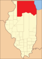
Putnam County when it was first created in 1825
-
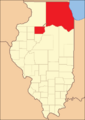
The county was split into two parts from 1827 to 1831
-
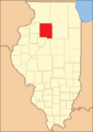
Putnam County between 1831 and 1837
-
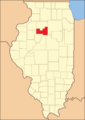
Putnam County between 1837 and 1839
-
Putnam County in 1839, looking like it does today


People of Putnam County
| Historical population | |||
|---|---|---|---|
| Census | Pop. | %± | |
| 1840 | 2,131 | — | |
| 1850 | 3,924 | 84.1% | |
| 1860 | 5,587 | 42.4% | |
| 1870 | 6,280 | 12.4% | |
| 1880 | 5,554 | −11.6% | |
| 1890 | 4,730 | −14.8% | |
| 1900 | 4,746 | 0.3% | |
| 1910 | 7,561 | 59.3% | |
| 1920 | 7,579 | 0.2% | |
| 1930 | 5,235 | −30.9% | |
| 1940 | 5,289 | 1.0% | |
| 1950 | 4,746 | −10.3% | |
| 1960 | 4,570 | −3.7% | |
| 1970 | 5,007 | 9.6% | |
| 1980 | 6,085 | 21.5% | |
| 1990 | 5,730 | −5.8% | |
| 2000 | 6,086 | 6.2% | |
| 2010 | 6,006 | −1.3% | |
| 2020 | 5,637 | −6.1% | |
| 2023 (est.) | 5,561 | −7.4% | |
| U.S. Decennial Census 1790-1960 1900-1990 1990-2000 2010 |
|||
In 2010, about 6,006 people lived in Putnam County. Most people (96.6%) were white. Other groups included Black or African American, Asian, and American Indian people. About 4.2% of the population was of Hispanic or Latino background. Many families in the county have roots in places like Germany, Ireland, Italy, and Poland.
The average age of people in Putnam County in 2010 was about 45 years old. About 27.7% of households had children under 18 living with them.
Towns and Areas in Putnam County
Putnam County has several villages and smaller communities where people live.
Villages
Unincorporated Communities
These are smaller places that don't have their own local government like villages do.
- Florid
- Moronts
- Mount Palatine (partially in LaSalle County)
- Putnam
- Walnut Grove
Townships
Putnam County is divided into four main areas called townships:
- Granville
- Hennepin
- Magnolia
- Senachwine
See also
 In Spanish: Condado de Putnam (Illinois) para niños
