
Stephenson County, Illinois facts for kids
Quick facts for kids
Stephenson County
|
|
|---|---|

Stephenson County Courthouse
|
|

Location within the U.S. state of Illinois
|
|
 Illinois's location within the U.S. |
|
| Country | |
| State | |
| Founded | 1837 |
| Named for | Benjamin Stephenson |
| Seat | Freeport |
| Largest city | Freeport |
| Area | |
| • Total | 565 sq mi (1,460 km2) |
| • Land | 565 sq mi (1,460 km2) |
| • Water | 0.5 sq mi (1 km2) 0.09% |
| Population
(2020)
|
|
| • Total | 44,630 |
| • Estimate
(2023)
|
43,105 |
| • Density | 78.99/sq mi (30.499/km2) |
| Time zone | UTC−6 (Central) |
| • Summer (DST) | UTC−5 (CDT) |
| Congressional districts | 16th, 17th |
Stephenson County is a county located in the state of Illinois, in the United States. It's a place where many people live and work. The main city and the place where the county government is located is Freeport. In 2020, about 44,630 people lived here.
Contents
History of Stephenson County
The first person to settle in the area that became Stephenson County was William Waddams in 1832. He started a community called Waddams Grove.
By 1837, enough people lived in the area to create a new county. Land was taken from Jo Daviess and Winnebago counties to form Stephenson County. The county was named after Colonel Benjamin Stephenson. He was an important official in the early days of the Illinois Territory.
-
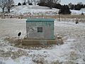
This marker shows where Waddams first settled in Stephenson County.
-
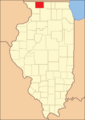
This map shows Stephenson County when it was first created in 1837. Its borders haven't changed since then.


Geography and Nature
Stephenson County covers a total area of about 565 square miles. Almost all of this area is land. Only a very small part, about 0.5 square miles, is water.
Weather in Stephenson County
| Weather chart for Freeport, Illinois | |||||||||||||||||||||||||||||||||||||||||||||||
|---|---|---|---|---|---|---|---|---|---|---|---|---|---|---|---|---|---|---|---|---|---|---|---|---|---|---|---|---|---|---|---|---|---|---|---|---|---|---|---|---|---|---|---|---|---|---|---|
| J | F | M | A | M | J | J | A | S | O | N | D | ||||||||||||||||||||||||||||||||||||
|
1.3
25
9
|
1.3
31
14
|
2.1
43
25
|
3.2
57
36
|
4
69
47
|
4.5
78
57
|
3.6
82
62
|
4.1
80
59
|
3.7
73
50
|
2.6
61
39
|
2.7
44
28
|
1.7
30
16
|
||||||||||||||||||||||||||||||||||||
| temperatures in °F precipitation totals in inches source: The Weather Channel |
|||||||||||||||||||||||||||||||||||||||||||||||
|
Metric conversion
|
|||||||||||||||||||||||||||||||||||||||||||||||
The weather in Stephenson County changes throughout the year. In the county seat of Freeport, temperatures usually range from about 9°F (which is very cold!) in January to a warm 82°F in July.
However, temperatures can go even lower or higher. The coldest temperature ever recorded was -29°F in January 2009. The hottest was 101°F in July 1988. The county also gets rain and snow. The most rain usually falls in June, with about 4.46 inches. January is usually the driest month.
Neighboring Counties
Stephenson County shares its borders with several other counties:
- Green County, Wisconsin (to the north)
- Winnebago County (to the east)
- Ogle County (to the southeast)
- Carroll County (to the southwest)
- Jo Daviess County (to the west)
- Lafayette County, Wisconsin (to the northwest)
Main Roads and Highways
Several important roads run through Stephenson County, helping people travel and connect communities:
 US Highway 20
 Illinois Route 26
 Illinois Route 73
 Illinois Route 75
People of Stephenson County
| Historical population | |||
|---|---|---|---|
| Census | Pop. | %± | |
| 1840 | 2,800 | — | |
| 1850 | 11,666 | 316.6% | |
| 1860 | 25,112 | 115.3% | |
| 1870 | 30,608 | 21.9% | |
| 1880 | 31,963 | 4.4% | |
| 1890 | 31,338 | −2.0% | |
| 1900 | 34,933 | 11.5% | |
| 1910 | 36,821 | 5.4% | |
| 1920 | 37,743 | 2.5% | |
| 1930 | 40,064 | 6.1% | |
| 1940 | 40,646 | 1.5% | |
| 1950 | 41,595 | 2.3% | |
| 1960 | 46,207 | 11.1% | |
| 1970 | 48,861 | 5.7% | |
| 1980 | 49,536 | 1.4% | |
| 1990 | 48,052 | −3.0% | |
| 2000 | 48,979 | 1.9% | |
| 2010 | 47,711 | −2.6% | |
| 2020 | 44,630 | −6.5% | |
| 2023 (est.) | 43,105 | −9.7% | |
| US Decennial Census 1790–1960 1900–1990 1990–2000 2010–2013 |
|||
In 2010, there were 47,711 people living in Stephenson County. The population density was about 84.5 people per square mile. This means that, on average, about 84 or 85 people lived in every square mile of the county.
Most people in the county were white (86.5%). About 9.0% were Black or African American. People of Hispanic or Latino background made up 2.9% of the population. Many families in Stephenson County have German roots (46.6%). Others have Irish (12.5%) or English (10.0%) backgrounds.
The average age of people in the county was 43.1 years old. About 28.6% of households had children under 18 living with them. The average household had 2.36 people. The average family had 2.90 people.
The median income for a household was $43,304. This means half of the households earned more than this amount, and half earned less. For families, the median income was $54,224. About 14.8% of all people in the county lived below the poverty line. This included 24.1% of those under 18 years old.
Education in Stephenson County
Stephenson County has many school districts. These districts help educate students from kindergarten all the way through high school. Some of these districts also serve parts of other counties.
School Districts
- Dakota Community Unit School District 201
- Durand Community Unit School District 322
- Eastland Community Unit School District 308
- Forrestville Valley Community Unit School District 221
- Freeport School District 145
- Lena-Winslow Community Unit School District 202
- Orangeville Community Unit School District 203
- Pearl City Community Unit School District 200
- Pecatonica Community Unit School District 321
- Warren Community Unit School District 205
- Winnebago Community Unit School District 323
High Schools
There are five public high schools and one private high school in Stephenson County. Here are their approximate student numbers:
Public High Schools
- Freeport High (about 1,254 students)
- Lena-Winslow High (about 299 students)
- Dakota High (about 254 students)
- Pearl City High (about 150 students)
- Orangeville High (about 142 students)
Private High School
- Aquin Catholic High (about 93 students)
Communities in Stephenson County
Stephenson County has one main city and many smaller towns and villages. It also has some census-designated places and unincorporated communities.

City
Villages
Census-Designated Places
These are areas that are like villages but are not officially incorporated as one.
- Baileyville (part)
- Lake Summerset
- Willow Lake
Unincorporated Communities
These are smaller communities that do not have their own local government.
- Afolkey
- Bolton
- Buckhorn Corners
- Buena Vista
- Damascus
- Eleroy
- Evarts
- Florence
- Kent
- Loran
- McConnell
- Oneco
- Red Oak
- Rock Grove
- Scioto Mills
- Waddams Grove
- Winneshiek
- Yellow Creek
Townships
Townships are smaller local government areas within the county.
- Buckeye
- Dakota
- Erin
- Florence
- Freeport
- Harlem
- Jefferson
- Kent
- Lancaster
- Loran
- Oneco
- Ridott
- Rock Grove
- Rock Run
- Silver Creek
- Waddams
- West Point
- Winslow
Historic Sites
See also
 In Spanish: Condado de Stephenson para niños
