Orangeville, Illinois facts for kids
Quick facts for kids
Orangeville
|
|
|---|---|
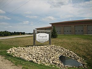
Sign upon entering the village of Orangeville.
|
|
| Motto(s):
The best little town on earth.
|
|
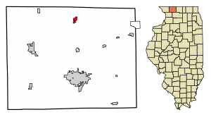
Location of Orangeville in Stephenson County, Illinois.
|
|

Location of Illinois in the United States
|
|
| Country | United States |
| State | Illinois |
| County | Stephenson |
| Township | Oneco |
| Founded | 1851 |
| Area | |
| • Total | 0.68 sq mi (1.75 km2) |
| • Land | 0.68 sq mi (1.75 km2) |
| • Water | 0.00 sq mi (0.00 km2) |
| Elevation | 820 ft (250 m) |
| Population
(2020)
|
|
| • Total | 766 |
| • Density | 1,133.14/sq mi (437.61/km2) |
| ZIP Code(s) |
61060
|
| Area code(s) | 815 |
| FIPS code | 17-56341 |
| Website | http://villageoforangeville.com/ |
Orangeville is a small village located in Stephenson County, Illinois, in the United States. As of 2020, about 738 people live there. The village sign in January 2021 showed a population of 800. Orangeville was founded in 1851 by John Bower and became an official village in 1867.
The village is known for its historic downtown area, which has many buildings from the 1800s. These were built when the railroad arrived between 1888 and 1914. Orangeville is about 2 miles (3 km) south of the Illinois-Wisconsin border. It is located right off Illinois Route 26. The local schools are part of the Orangeville Community School District #203.
Contents
Orangeville's Early Days and Growth
First Settlers and Mills
Before 1837, the Orangeville area was used as hunting grounds by Native American tribes. In 1838, a man named John H. Curtis bought 80 acres (32 ha) of land here. He built a dam on Richland Creek and set up a gristmill (for grinding grain) and a saw mill (for cutting wood).
After Curtis passed away in 1843, the mills stopped working. Then, in 1846, John Bower bought the land and the mills. He is known as the founder of Orangeville.
Founding the Village
Many farmers from New York and Pennsylvania, often called the Pennsylvania Dutch, moved to this area in the 1830s and 1840s. John Bower officially planned out the village of Orangeville in 1851. He also built a building called the Union House in 1849. Even though the town was planned in 1851, it didn't become an official village until 1867.
Bower brought lots of lumber to the settlement. By 1850, he had rebuilt and improved the gristmill. Other people started to arrive, like Charles Moore, who would become the first village president. A store was built, and farmers began to build homes. By 1850, a stagecoach service reached the area. The first church in Orangeville began construction in 1852.
Winning the Post Office Location
By 1854, Orangeville was growing and competing with a nearby village called Oneco. The United States government decided that one of the villages needed a post office. To decide, residents from both villages lined up to show which town they supported. Orangeville won by a small number of people!
The Railroad Arrives in Orangeville
After becoming an official village, Orangeville continued to grow. The downtown area was mostly finished by the 1870s. In 1887, the Illinois Central Railroad decided to build a train line connecting Freeport to Madison, Wisconsin. Orangeville was the only official village along this new line.
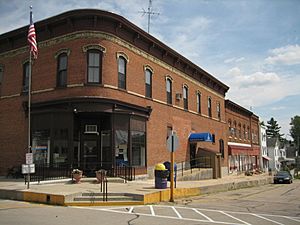
The railroad arrived in 1888, which caused a big building boom in Orangeville. Fourteen new brick buildings were built downtown during this time. Many different businesses opened between 1888 and 1914. These included restaurants, drug stores, barber shops, banks, and even a cigar factory.
Challenges During the Great Depression
In 1928, just before the Great Depression began, Illinois State Highway 74 (now Illinois Route 26) was changed. It was rerouted to go through the eastern part of Orangeville, bypassing the main downtown area. This meant less traffic and fewer customers for downtown businesses.
The Great Depression, a time of economic hardship, also hurt Orangeville. In 1932, the People's State Bank, which was the last bank in Orangeville, closed down. However, in 1956, a new bank opened in the village and is still there today.
Orangeville's Location and Landscape
Orangeville is located at 42°28′1″N 89°38′46″W / 42.46694°N 89.64611°W. It covers about 0.63 square miles (1.63 square kilometers) of land. The village is in northern Stephenson County, about 2 miles (3 km) south of the Illinois-Wisconsin border. You can find it directly off Illinois Route 26.
Orangeville is about 11 miles (18 km) south of Monroe, Wisconsin, and 12 miles (19 km) north of Freeport. It's also about 35 miles (56 km) west of Rockford. The village sits in a valley surrounded by farmland. Richland Creek runs through the western part of town. The old railroad track bed is now part of the Jane Addams Trail, which is a path for walking and biking.
Downtown Orangeville and Historic Buildings
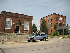
The main downtown area of Orangeville is along High and Main Streets. High Street goes uphill from Richland Creek and is lined with historic buildings from the 1800s. At the top of High Street is the Central House, which is a very old hotel building. It is listed on the U.S. National Register of Historic Places.
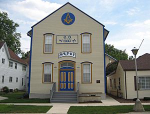
The Central House was the first commercial brick building built in the downtown area. It operated as a hotel from the 1860s until the 1930s. Other historic buildings in this area include the Union House and the Orangeville Masonic Hall. The People's State Bank was one of the last big commercial buildings built in historic downtown Orangeville.
In 2020, the old Elementary School building was turned into a multi-family apartment complex. It now has 20 studio apartments and common areas.
Community Life and Organizations
Social Groups and Fraternities
Social and fraternal organizations have always been important in Orangeville. These groups help people connect and support the community. In 1876, the local Ancient Free and Accepted Masons (AF and AM) Lodge built the Orangeville Masonic Hall. This building has been used by many different groups in Orangeville.
The Orangeville AF and AM Lodge 687 started in 1872. Its sister group, the Eastern Star, began in 1899. These groups held meetings on the second floor of the Masonic Hall. The first floor was used for fun events and social gatherings. The Masonic Lodge is still active in Orangeville today.
Another group, the Orangeville Independent Order of Odd Fellows (IOOF) J.R. Scruggs Lodge 372, was formed in 1868. They also helped start their sister group, the Rebekah Lodge, in 1896.
In late 2014, Orangeville became famous for something unique: a cow named Blosom, who lived at the Hanson Farm, received the Guinness World Record for the world's tallest dairy cow!
Population Information
| Historical population | |||
|---|---|---|---|
| Census | Pop. | %± | |
| 1870 | 255 | — | |
| 1880 | 326 | 27.8% | |
| 1890 | 347 | 6.4% | |
| 1900 | 343 | −1.2% | |
| 1910 | 370 | 7.9% | |
| 1920 | 423 | 14.3% | |
| 1930 | 383 | −9.5% | |
| 1940 | 407 | 6.3% | |
| 1950 | 460 | 13.0% | |
| 1960 | 491 | 6.7% | |
| 1970 | 538 | 9.6% | |
| 1980 | 598 | 11.2% | |
| 1990 | 451 | −24.6% | |
| 2000 | 751 | 66.5% | |
| 2010 | 793 | 5.6% | |
| 2020 | 738 | −6.9% | |
| U.S. Decennial Census | |||
According to the 2020 census, Orangeville had a population of 738 people. This makes it the 741st largest city in Illinois. Since the 2010 census, the population has decreased slightly.
In 2000, there were 751 people living in the village. Most residents were White. About 39.7% of households had children under 18. The average household had 2.53 people. The median age in the village was 34 years old.
Education in Orangeville
Public education in Orangeville is managed by the Orangeville Community School District #203. The district has one main building, called the Orangeville Illinois CUSD. This building houses both the elementary school and the junior and senior high school, which is known as Orangeville Jr/Sr High School. The high school sports teams are called the Broncos. The school district is run by a seven-member Board of Education.
Notable People from Orangeville
- Art Young, a famous cartoonist
See also
 In Spanish: Orangeville (Illinois) para niños
 | Percy Lavon Julian |
 | Katherine Johnson |
 | George Washington Carver |
 | Annie Easley |


