Elwood, Iowa facts for kids
Quick facts for kids
Elwood, Iowa
|
|
|---|---|

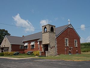
Elwood United Methodist Church
|
|
| Country | United States |
| State | Iowa |
| County | Clinton |
| Elevation | 738 ft (225 m) |
| Time zone | UTC-6 (Central (CST)) |
| • Summer (DST) | UTC-5 (CDT) |
| Area code(s) | 563 |
| GNIS feature ID | 456353 |
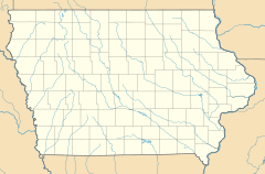
Elwood is a small, unincorporated community located in the northwestern part of Clinton County, Iowa, in the United States. An "unincorporated community" means it's a place where people live, but it doesn't have its own local government like a city or town. It's situated along Iowa Highway 136, which is a road that helps people travel through the area. Elwood is about 5 miles (8 km) east of a place called Lost Nation. It sits at an elevation of 738 feet (225 meters) above sea level.
The History of Elwood
Elwood has an interesting past, even though it's a small community today. In 1871, a post office was opened in Elwood, which was an important service for people living there. The community was officially named in honor of Kinsey Elwood. He was the person who planned out the town in 1873, deciding where streets and lots would go.
Elwood's Population Over Time
Like many small communities, Elwood's population has changed over the years. For example, in 1940, the community had a population of 100 people. This kind of information helps us understand how places grow or shrink over time.
 | Isaac Myers |
 | D. Hamilton Jackson |
 | A. Philip Randolph |


