
Wesleyville, Pennsylvania facts for kids
Quick facts for kids
Wesleyville, Pennsylvania
|
|
|---|---|
|
Borough
|
|

Buffalo Road (US 20) through Wesleyville
|
|

Location in Erie County and the U.S. state of Pennsylvania.
|
|
| Country | United States |
| State | Pennsylvania |
| County | Erie |
| Area | |
| • Total | 0.53 sq mi (1.37 km2) |
| • Land | 0.53 sq mi (1.37 km2) |
| • Water | 0.00 sq mi (0.00 km2) |
| Elevation | 723 ft (220 m) |
| Population
(2020)
|
|
| • Total | 3,229 |
| • Estimate
(2021)
|
3,196 |
| • Density | 5,881.13/sq mi (2,271.27/km2) |
| Time zone | UTC-4 (EST) |
| • Summer (DST) | UTC-5 (EDT) |
| ZIP code |
16510
|
| Area code(s) | 814 |
Wesleyville is a small town, also called a borough, located in Erie County, Pennsylvania, United States. In 2020, about 3,229 people lived there. This number was a little lower than in 2010. Wesleyville is part of the larger Erie area.
Contents
Where is Wesleyville Located?
Wesleyville is in a specific spot at 42°8′13″N 80°0′45″W / 42.13694°N 80.01250°W. It is next to the city of Erie on its west side. To the north, you'll find Lawrence Park Township. On its east and south sides, it shares borders with Harborcreek Township.
Size and Natural Features
The borough of Wesleyville covers a total area of about 1.37 square kilometers (or 0.53 square miles). All of this area is land. A stream called Fourmile Creek flows along the eastern edge of Wesleyville. This creek eventually flows into Lake Erie.
Who Lives in Wesleyville?
The number of people living in Wesleyville has changed over the years. In 1920, there were about 1,457 residents. The population grew quite a bit by the 1950s and 1960s, reaching its highest point in 1980 with nearly 4,000 people. Since then, the population has slowly decreased.
| Historical population | |||
|---|---|---|---|
| Census | Pop. | %± | |
| 1920 | 1,457 | — | |
| 1930 | 2,854 | 95.9% | |
| 1940 | 2,918 | 2.2% | |
| 1950 | 3,411 | 16.9% | |
| 1960 | 3,534 | 3.6% | |
| 1970 | 3,920 | 10.9% | |
| 1980 | 3,998 | 2.0% | |
| 1990 | 3,655 | −8.6% | |
| 2000 | 3,617 | −1.0% | |
| 2010 | 3,341 | −7.6% | |
| 2020 | 3,229 | −3.4% | |
| 2021 (est.) | 3,196 | −4.3% | |
| Sources: | |||
Community Life
In 2000, there were 1,441 households in Wesleyville. Many of these households had children under 18 living with them. The average household had about 2.5 people. The median age of people living in Wesleyville was 34 years old. This means half the people were younger than 34 and half were older.
Images for kids
-
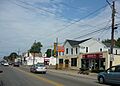
Buffalo Road (US 20) through Wesleyville
-
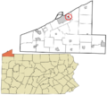
Location in Erie County and the U.S. state of Pennsylvania.
-

Robot for kids

See also
 In Spanish: Wesleyville para niños
