Fourmile Creek (Pennsylvania) facts for kids
Quick facts for kids Fourmile Creek |
|
|---|---|

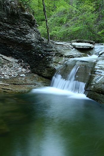
A waterfall on Fourmile Creek in Wintergreen Gorge
|
|
|
Location of the mouth of Fourmile Creek in Pennsylvania
|
|
| Country | United States |
| State | Pennsylvania |
| County | Erie |
| Physical characteristics | |
| Main source | Greene Township, Erie County, Pennsylvania 42°3′55″N 79°56′37″W / 42.06528°N 79.94361°W |
| River mouth | Lake Erie Lawrence Park, Erie County, Pennsylvania 42°9′36″N 80°1′47″W / 42.16000°N 80.02972°W |
| Length | 8.0 mi (12.9 km) |
| Basin features | |
| Basin size | 11.93 sq mi (30.9 km2) |
Fourmile Creek is a small river, also called a tributary, that flows into Lake Erie in Erie County, Pennsylvania, United States. It's about 8 miles (13 km) long. The area of land that drains into Fourmile Creek, called its drainage basin, is about 11.93 square miles (30.9 km2). This creek is an important part of the larger Lake Erie Watershed.
Contents
Where Fourmile Creek Flows
Fourmile Creek begins in Greene Township, just north of Pennsylvania Route 8. As it flows northwest, its valley gets deeper and deeper.
After several miles, the creek goes under Interstate 90. It then leaves Greene Township and enters Harborcreek Township. Here, the creek turns north, and its valley continues to deepen.
Later, the valley becomes less deep, and the creek flows under Pennsylvania Route 290. It then turns northwest again and follows the border between Harborcreek Township and the city of Erie. Finally, it enters Erie.
Once in Erie, the creek continues northwest. It passes through the Lawrence Park Golf Club before finally flowing into Lake Erie.
Water Quality and Flow
The water in Fourmile Creek has a pH level that usually ranges between 6 and 9. This means it's usually slightly acidic to slightly basic. The amount of salt in the water, called salinity, is very low.
The total amount of dissolved solids (like minerals) in the water ranges from 180 to 500 parts per million. In 1982, scientists measured different minerals. For example, the amount of sodium varied from 2.91 to 40.8 milligrams per liter.
The speed of the water in Fourmile Creek changes a lot. During floods, the water can rush at about 1.25 metres (4.1 ft) per second. But during dry periods, called droughts, it slows down to about 0.051 metres (0.17 ft) per second.
The amount of water flowing through the creek, known as discharge, also changes. It can be as low as 1400 cubic centimeters per second during droughts and as high as 91,000 cubic centimeters per second during floods.
The conductivity of the water, which shows how well it carries electricity, ranges from 274 to 747 micro-siemens. The water temperature changes with the seasons, from about 9.9 °C (49.8 °F) in cooler months to 24.5 °C (76.1 °F) in warmer ones.
In a study of 22 creeks that flow into Lake Erie, Fourmile Creek was ranked as having the fourth-lowest water quality. This means there are some pollution concerns. However, the upper parts of the creek have very little nonpoint source pollution, which is pollution that doesn't come from a single pipe or source.
There are two dams on Fourmile Creek. One is located in the Lawrence Park Golf Course. The other is south of Station Road. There's also a large piece of concrete in the creek that acts like a third small dam.
Rocks and Land Around the Creek
Fourmile Creek has one waterfall that is about 5 feet (1.5 m) high. You can find it between Cooper Road and Interstate 90.
In the upper parts of Fourmile Creek, you can see granite rocks. Sometimes, sheets of another rock called porphyry are mixed in with the granite. The area around the creek also has shale rock formations.
Near the creek, there's a very large mass of rhyolite rock. It's about 75 feet (23 m) thick, making it the biggest piece of this type of rock in Pennsylvania! Another rhyolite mass in the area is even thicker, about 250 feet (76 m).
In its upper sections, Fourmile Creek flows through a fairly narrow valley that is about 30 feet (9.1 m) deep. You might see loose rocks, called slide rock, in this valley.
Fourmile Creek is about 574 feet (175 m) above sea level.
History and Fish Access
Since 2007, people have been working to make Fourmile Creek better for steelhead fish. These efforts also aim to improve fishing access for people.
By 2011, two special ramps called fishways were added. These ramps help steelhead trout swim past obstacles in the creek, making it easier for them to reach their spawning grounds (where they lay their eggs).
In 2012, a golf course next to these improvements agreed to let the public use a path across their land. This agreement, called an easement, means people can now easily get to the fishways.
Animals and Plants of Fourmile Creek
A type of bacteria called Aeromonas veronii has been found in Fourmile Creek. Small creatures that live on the bottom of the creek, called benthic macroinvertebrates, can be found in the upper parts of the creek.
Scientists observed six different kinds of mayflies in the creek in the late 1970s and early 1980s. These included Paraleptophlebia strigula, Paraleptophlebia debilis, Habrophlebiodes americana, Baetis tricaudatus, Baetus flavistriga, and Ameletus ludens.
In the upper parts of Fourmile Creek, pine trees grow very thickly in the valley.
 | William M. Jackson |
 | Juan E. Gilbert |
 | Neil deGrasse Tyson |


