
Lake Erie Watershed (Pennsylvania) facts for kids
The Lake Erie Watershed is like a giant funnel that collects all the rain and melted snow from a large area of land. This water then flows into Lake Erie and Presque Isle Bay. It covers parts of northwestern Pennsylvania (in Crawford and Erie counties) and even some areas in New York. Think of it as a big neighborhood where all the water ends up in the same place!
Contents
The Lake Erie Watershed
A watershed is an area of land where all the water drains into a single river, lake, or ocean. The Lake Erie Watershed is a very important natural system. It helps to keep the lake healthy by managing how water flows into it. This includes water from small streams, rivers, and even direct runoff from the land.
Main Parts of the Watershed
The Lake Erie Watershed is made up of many smaller parts. These include "direct runoff" areas and several "sub-watersheds." Direct runoff means water flows straight into Lake Erie. Sub-watersheds are smaller areas where water collects into a stream or river before flowing into the lake.
Direct Runoff Areas
Some parts of Pennsylvania have land where water flows directly into Lake Erie. There are 24 such areas.
One important direct runoff zone is where the Erie International Airport is located. This airport works hard to prevent water pollution. For example, they have special plans to manage storm drainage and water from deicing operations. These plans help protect the water quality in the watershed.
Important Sub-watersheds
Many streams and small rivers make up the sub-watersheds that feed into Lake Erie. Each one plays a role in the health of the larger watershed.
Cemetery Run Sub-watershed
Cemetery Run starts near E 38th Street in Millcreek. It flows through Roma Park and then continues to Lake Erie near Lakeside Cemetery. A lot of this stream flows underground or through pipes because of buildings and roads.
Duck Run Sub-watershed
Duck Run is another stream that flows into Lake Erie. Its mouth, where it meets the lake, is a notable feature at Erie Bluffs State Park.

Elk Creek Sub-watershed
This sub-watershed includes Elk Creek and the land around it. This area covers parts of Elk Creek, Franklin, and Girard townships in Erie County. Elk Creek is one of the streams that can affect the water quality at nearby Presque Isle State Park.
Fourmile Creek Sub-watershed
Fourmile Creek is about 8 miles (13 km) long. It gets its name because it's located about four miles (6 km) east of the center of Erie, Pennsylvania. The creek's mouth opens into Lake Erie. Projects have been done to help fish move more easily in the creek, like removing dams. Plans are also in place to reduce soil erosion, which can cause mud and dirt to wash into the creek.

McDannell Run Sub-watershed
McDannell Run flows through parts of the City of Erie and slightly into Millcreek Township. It passes through McClelland Park, which is a natural park area.
Presque Isle Bay Watershed
This watershed is a special area that covers about 65 square kilometers. It includes land in the City of Erie and two nearby townships. All the water from this area flows into Presque Isle Bay. The bay then connects to Lake Erie through a small channel.
The Environmental Protection Agency (EPA) has called this area a "Great Lakes Area of Concern." This is because a lot of the land is developed, and stormwater runoff can harm fish habitats. Efforts are being made to improve the water quality here, especially as the city focuses more on tourism.
- Cascade Creek Sub-watershed includes Cascade Creek in the City of Erie. The creek flows through Frontier Park, a popular spot in the city.
- Garrison Run Sub-watershed is also in the City of Erie. This stream has a single outlet that flows into Presque Isle Bay.
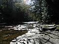
- Mill Creek Sub-watershed includes Mill Creek and the land around it in Erie, Millcreek, Summit, and Greene townships. A long time ago, Mill Creek used to flood the city often. To stop this, a large underground pipe called the Mill Creek Tube was built in 1915 to carry the creek's water safely under the city.

Sixmile Creek Sub-watershed
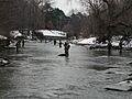
Sixmile Creek is another important stream in the watershed. It flows through Six Mile Creek (Erie County) Park, a natural area.

Trout Run Sub-watershed
This sub-watershed includes Trout Run and the surrounding land in Fairview Township. It also touches parts of McKean and Girard townships. Like Elk Creek, Trout Run can affect the water quality at Presque Isle State Park.
Twentymile Creek Sub-watershed
Twentymile Creek is unique because it extends into New York. This shows how watersheds can cross state borders.
Walnut Creek Sub-watershed
Walnut Creek is a very important stream in the watershed. It flows through many areas, including parts of the City of Erie, Fairview Township, Greene Township, McKean Township, Millcreek Township, and Summit Township.
Many important places are in this sub-watershed, like Asbury Woods Community Park and Nature Center and the Millcreek Mall. The Presque Isle Downs race track, located here, has built special wetlands to help manage water runoff from the horse barns.
Most of the wastewater from homes is treated at a special facility and then released into Lake Erie. There are also some smaller private treatment plants. Walnut Creek is another stream that can affect the water quality at Presque Isle State Park.

Images for kids
-
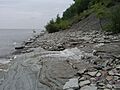
Mouth of Duck Run, Erie Bluffs State Park
-
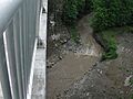
Four Mile Creek, Wintergreen Gorge Bridge
-

Mill Creek south of tube in City of Erie
-
Six Mile Creek in Six Mile Creek (Erie County) Park
-
Mouth of Walnut Creek, Access Area
